FAA INFORMATION EFFECTIVE 11 JUNE 2026
Location
| FAA Identifier: | W95 |
| Lat/Long: | 35-06-04.2000N 075-57-57.5000W
35-06.070000N 075-57.958333W
35.1011667,-75.9659722
(estimated) |
| Elevation: | 4 ft. / 1.2 m (surveyed) |
| Variation: | 09W (1985) |
| From city: | 1 mile E of OCRACOKE, NC |
| Time zone: | UTC -4 (UTC -5 during Standard Time) |
| Zip code: | 27960 |
Airport Operations
| Airport use: | Open to the public |
| Activation date: | 05/1969 |
| Control tower: | no |
| ARTCC: | WASHINGTON CENTER |
| FSS: | RALEIGH FLIGHT SERVICE STATION |
| NOTAMs facility: | RDU (NOTAM-D service available) |
| Attendance: | UNATNDD |
| Wind indicator: | yes, WINDSOCK FOR HELI LGTD. |
| Segmented circle: | no |
| Lights: | ACTVT HELI PERIMETER LTS ONLY - CTAF. |
| Beacon: | white-green-yellow (heliport)
ACTVT HELI BEACON - CTAF. |
Airport Communications
| CTAF: | 122.9 |
| CHERRY POINT APPROACH: | 119.75 |
| CHERRY POINT DEPARTURE: | 119.75 |
| WX ASOS at HSE (19 nm NE): | 118.375 (252-552-1005) |
Airport Services
| Parking: | tiedowns |
| Airframe service: | NONE |
| Powerplant service: | NONE |
| Bottled oxygen: | NONE |
| Bulk oxygen: | NONE |
Runway Information
Runway 6/24
| Dimensions: | 2998 x 60 ft. / 914 x 18 m |
| Surface: | asphalt, in fair condition |
| Weight bearing capacity: | |
| RUNWAY 6 | | RUNWAY 24 |
| Latitude: | 35-05.912480N | | 35-06.227332N |
| Longitude: | 075-58.189330W | | 075-57.725703W |
| Elevation: | 3.9 ft. | | 3.9 ft. |
| Traffic pattern: | left | | left |
| Runway heading: | 059 magnetic, 050 true | | 239 magnetic, 230 true |
| Markings: | nonprecision, in fair condition | | nonprecision, in fair condition |
| Touchdown point: | yes, no lights | | yes, no lights |
| Obstructions: | 5 ft. brush, 226 ft. from runway, 107 ft. left of centerline, 5:1 slope to clear
5 FT BRUSH 0-200 FT FM THR 81 FT R OF CNTRLN; 5 FT BRUSH 50-200 FT FM THR 145 FT L OF CNTRLN. | | 9 ft. brush, 226 ft. from runway, 45 ft. left of centerline, 2:1 slope to clear
12 FT SCRUB TREES 155 FT FM THR 94 FT R OF CNTRLN; 10 FT SCRUB TREES 0-200 FT FM THR 74 FT L OF CNTRLN. |
Helipad H1
| Dimensions: | 100 x 100 ft. / 30 x 30 m |
| Surface: | concrete, in good condition |
| Runway edge lights: | PERI |
| Operational restrictions: | BEST APCH FM NE OR SW. |
| Latitude: | 35-06.313333N | | |
| Longitude: | 075-57.721833W | | |
| Elevation: | 4.0 ft. | | |
| Traffic pattern: | left | | left |
| Markings: | basic, in good condition | | |
| Obstructions: | 15 ft. trees, 151 ft. from runway, 10:1 slope to clear
APCH SLOPE FOR NE HELI APCH IS 13:1 DUE TO 12 FT BRUSH 162 FT FM HELI OFFSET 31 FT L; AND APCH SLOPE FOR SW HELI APCH IS 10:1 DUE TO 15 FT TREES 151 FT FROM HELI OFFSET 0 FT BOTH SIDES. | | |
Airport Ownership and Management from official FAA records
| Ownership: | Publicly-owned |
| Owner: | NATIONAL PARK SERVICE
1401 NATIONAL PARK DR.
MANTEO, NC 27954
Phone 252-475-9000
NCDOT DIVISION OF AVIATION COOPERATING AGENCY UNDER MOU; CTC NR 919-814-0550. |
| Manager: | MARK SEAMAN
1401 NATIONAL PARK DRIVE
MANTEO, NC 27954
Phone 252-475-9000
NATL PARKS SVC NR ANSWERED 7 DAYS A WEEK BTWN 0800 TO 1700. |
Additional Remarks
| - | ARPT CLSD 30 MIN AFTER SS TIL 30 MIN BEFORE SR. |
| - | FOR CD CTC WASHINGTON ARTCC AT 703-771-3587. |
| - | 30 FT PLINE ALONG NC HWY 12 N OF HELIPAD. |
| - | HIGH SPEED LOW LEVEL MIL OPS INVOF OF ARPT. |
| - | FLOCKS OF SEAGULLS ON AND NEAR RWY ARND STANDING WATER AFTER HVY RAINS. |
| - | RWY SAFETY AREA IS LOOSE SAND; NOT SUITABLE FOR ACFT. |
| - | RWY NOT LGTD - NIGHT OPS PROHIBITED. |
| - | ARPT IS WI CAPE HATTERAS NTL SEASHORE. MNTN 2000 FT VER & HORIZONTAL DIST FROM SEASHORE BEACHES. |
| - | RWY SUBJ RESIDUAL FLOODING DURG AND AFT HEAVY RAIN. |
| - | KEY CODE ACES TO PILOT LOUNGE. |
| - | HELIPAD FOR EMERG OPS ONLY. |
Instrument Procedures
NOTE: All procedures below are presented as PDF files. If you need a reader for these files, you should download the free Adobe Reader.NOT FOR NAVIGATION. Please procure official charts for flight.
FAA instrument procedures published for use from 11 June 2026 at 0901Z to 09 July 2026 at 0900z.
IAPs - Instrument Approach Procedures |
|---|
| RNAV (GPS) RWY 06 | |
download (208KB) |
| RNAV (GPS) RWY 24 | |
download (212KB) |
Other nearby airports with instrument procedures:
KHSE - Billy Mitchell Airport (19 nm NE)
7W6 - Hyde County Airport (28 nm N)
KMRH - Michael J Smith Field Airport (41 nm SW)
KNKT - Cherry Point Marine Corps Air Station (Cunningham Field) Airport (47 nm W)
KMQI - Dare County Regional Airport (51 nm N)
|
|

Road maps at:
MapQuest
Bing
Google
| Aerial photo |
|---|
WARNING: Photo may not be current or correct
 Photo by Greg Marut
Photo taken 28-Jul-2019
looking northeast.
Photo by Greg Marut
Photo taken 28-Jul-2019
looking northeast.
Do you have a better or more recent aerial photo of Ocracoke Island Airport that you would like to share? If so, please send us your photo.
|
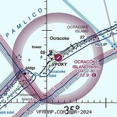
| Sectional chart |
|---|
|
| Airport distance calculator |
|---|
|
|
| Sunrise and sunset |
|---|
|
Times for 03-Jul-2026
| | Local
(UTC-4) | | Zulu
(UTC) |
|---|
| Morning civil twilight | | 05:26 | | 09:26 |
| Sunrise | | 05:55 | | 09:55 |
| Sunset | | 20:21 | | 00:21 |
| Evening civil twilight | | 20:51 | | 00:51 |
|
| Current date and time |
|---|
| Zulu (UTC) | 04-Jul-2026 01:52:59 |
|---|
| Local (UTC-4) | 03-Jul-2026 21:52:59 |
|---|
|
| METAR |
|---|
KHSE
19nm NE | 040051Z AUTO 21009KT 10SM CLR 28/23 A3001 RMK AO2 SLP163 T02780228 $
|
KNBT
25nm W | 040051Z AUTO 19007KT 10SM CLR 27/22 A3002 RMK AO2 SLP170 T02670222
|
K7W6
28nm N | 040135Z AUTO 20004KT 10SM CLR 27/24 A3003 RMK AO2 T02660235
|
K2DP
35nm N | 040055Z AUTO 20006KT 10SM CLR 27/25 A2999 RMK AO2 SLP162 T02700254 $
|
|
| TAF |
|---|
KNKT
46nm W | 032100Z 0321/0421 VRB06KT 9999 SCT040 QNH3003INS BECMG 0400/0402 VRB06KT 9999 SKC QNH2995INS TX35/0418Z TN23/0409Z
|
|
| NOTAMs |
|---|
NOTAMs are issued by the DoD/FAA and will open in a separate window not controlled by AirNav.
|
|

