FAA INFORMATION EFFECTIVE 16 APRIL 2026
Location
| FAA Identifier: | MQI |
| Lat/Long: | 35-55-08.3380N 075-41-43.9290W
35-55.138967N 075-41.732150W
35.9189828,-75.6955358
(estimated) |
| Elevation: | 12.8 ft. / 3.9 m (surveyed) |
| Variation: | 09W (1985) |
| From city: | 1 mile NW of MANTEO, NC |
| Time zone: | UTC -4 (UTC -5 during Standard Time) |
| Zip code: | 27954 |
Airport Operations
| Airport use: | Open to the public |
| Activation date: | 09/1943 |
| Control tower: | no |
| ARTCC: | WASHINGTON CENTER |
| FSS: | RALEIGH FLIGHT SERVICE STATION |
| NOTAMs facility: | MQI (NOTAM-D service available) |
| Attendance: | 0800-1900
UNATNDD CHRISTMAS DAY. FOR SVC AFT HRS CALL 252-216-7028 OR 252-216-8407. |
| Wind indicator: | lighted |
| Segmented circle: | yes |
| Lights: | PAPI RWY 05 & 23 OPR CONSLY, SS-SR - CTAF. ACTVT REIL RWY 05, 23; MIRL RWY 05/23 & 17/35 - CTAF. |
| Beacon: | white-green (lighted land airport)
Operates sunset to sunrise. |
Airport Communications
| CTAF/UNICOM: | 122.8 |
| WX AWOS-3: | 128.275 (252-473-2826) |
| CHERRY POINT APPROACH: | 124.725 |
| CHERRY POINT DEPARTURE: | 124.725 |
| WX AWOS-3 at FFA (6 nm N): | 118.075 (252-449-0698) |
Nearby radio navigation aids
| VOR radial/distance | | VOR name | | Freq | | Var |
|---|
| RBX at field | | WRIGHT BROTHERS VOR/DME | | 111.60 | | 08W |
| ECGr138/30.9 | | ELIZABETH CITY VOR/DME | | 115.75 | | 07W |
| NDB name | | Hdg/Dist | | Freq | | Var | | ID |
|---|
| MANTEO | | at field | | 370 | | 09W | | MQI | -- --.- .. |
| WOODVILLE | | 135/35.8 | | 254 | | 10W | | LLW | .-.. .-.. .-- |
Airport Services
| Fuel available: | 100LL JET-A1+
100LL:100LL AVBL AFT HRS SELF SVC WITH CREDIT CARD. |
| Parking: | hangars and tiedowns |
| Airframe service: | MAJOR |
| Powerplant service: | MAJOR |
| Bottled oxygen: | NONE |
| Bulk oxygen: | NONE |
Runway Information
Runway 5/23
| Dimensions: | 4306 x 100 ft. / 1312 x 30 m |
| Surface: | asphalt, in excellent condition |
| Weight bearing capacity: | |
| Runway edge lights: | medium intensity |
| RUNWAY 5 | | RUNWAY 23 |
| Latitude: | 35-54.837537N | | 35-55.396470N |
| Longitude: | 075-42.045227W | | 075-41.507538W |
| Elevation: | 9.0 ft. | | 12.1 ft. |
| Traffic pattern: | left | | left |
| Runway heading: | 047 magnetic, 038 true | | 227 magnetic, 218 true |
| Displaced threshold: | 305 ft. | | 301 ft. |
| Markings: | nonprecision, in good condition | | nonprecision, in good condition |
| Visual slope indicator: | 4-light PAPI on left (3.00 degrees glide path) | | 4-light PAPI on left (4.00 degrees glide path) |
| Runway end identifier lights: | yes | | yes |
| Touchdown point: | yes, no lights | | yes, no lights |
| Obstructions: | none | | 25 ft. bldg, 301 ft. from runway, 262 ft. left of centerline, 4:1 slope to clear
7 FT FENCE 100-300 FT FM END OF PAVEMENT BOTH SIDES OF CNTRLN; 15 FT ROAD 90 FT FM END OF PAVEMENT AND BOTH SIDES OF CNTRLN; 12 FT TRUCK 193 FT FM END OF PAVEMENT OFFSET 120 FT LEFT OF CNTRLN. |
Runway 17/35
| Dimensions: | 3303 x 75 ft. / 1007 x 23 m |
| Surface: | asphalt, in good condition |
| Weight bearing capacity: | |
| Runway edge lights: | medium intensity |
| RUNWAY 17 | | RUNWAY 35 |
| Latitude: | 35-55.419973N | | 35-54.915253N |
| Longitude: | 075-41.799742W | | 075-41.549152W |
| Elevation: | 12.6 ft. | | 9.5 ft. |
| Traffic pattern: | left | | left |
| Runway heading: | 167 magnetic, 158 true | | 347 magnetic, 338 true |
| Displaced threshold: | 290 ft. | | 989 ft. |
| Markings: | nonprecision, in good condition | | nonprecision, in good condition |
| Touchdown point: | yes, no lights | | yes, no lights |
| Obstructions: | 67 ft. trees, 364 ft. from runway, 261 ft. left of centerline, 2:1 slope to clear
APCH SLOPE 6:1 AT DSPLCD. | | 80 ft. trees, 615 ft. from runway, 206 ft. right of centerline, 5:1 slope to clear
9 FT BRUSH 131 FT FM END OF PAVEMENT OFFSET 16 FT RIGHT OF CNTRLN. |
Airport Ownership and Management from official FAA records
| Ownership: | Publicly-owned |
| Owner: | DARE COUNTY AIRPORT AUTHORITY
410 AIRPORT ROAD
MANTEO, NC 27954
Phone 252-475-5570 |
| Manager: | STACY AMBROSE
410 AIRPORT ROAD
MANTEO, NC 27954-9110
Phone 252-475-5571 |
Additional Remarks
| - | RWY 05 15 FT DROP-OFF 40 FT FM THR 0B. |
| - | TWY F CLSD PERMLY. |
| - | FOR CD CTC CHERRY POINT APCH AT 252-466-5960, OR WHEN APCH CLSD CTC WASHINGTON ARTCC AT 703-771-3587. |
| - | MIGRATORY WATERFOWL OCT - FEB. |
| - | BANNER TOWING OPNS 200 FT W OF RWY 05. |
| - | SEAPLANE RAMP NEAR APRON. |
Instrument Procedures
NOTE: All procedures below are presented as PDF files. If you need a reader for these files, you should download the free Adobe Reader.NOT FOR NAVIGATION. Please procure official charts for flight.
FAA instrument procedures published for use from 16 April 2026 at 0901Z to 14 May 2026 at 0900Z.
IAPs - Instrument Approach Procedures |
|---|
| RNAV (GPS) RWY 05 | |
download (235KB) |
| RNAV (GPS) RWY 17 | |
download (225KB) |
| RNAV (GPS) RWY 23 | |
download (230KB) |
| NOTE: Special Alternate Minimums apply | |
download (25KB) |
| NOTE: Special Take-Off Minimums/Departure Procedures apply **CHANGED** | |
download (394KB) |
Other nearby airports with instrument procedures:
KFFA - First Flight Airport (6 nm N)
7W6 - Hyde County Airport (25 nm SW)
KECG - Elizabeth City Coast Guard Air Station/Regional Airport (31 nm NW)
KONX - Currituck County Regional Airport (33 nm NW)
KHSE - Billy Mitchell Airport (41 nm S)
|
|

Road maps at:
MapQuest
Bing
Google
| Aerial photo |
|---|
WARNING: Photo may not be current or correct
 Photo by David Newcomer
Taken in June 2009
from 3000' altitude looking East.
Photo by David Newcomer
Taken in June 2009
from 3000' altitude looking East.
Do you have a better or more recent aerial photo of Dare County Regional Airport that you would like to share? If so, please send us your photo.
|
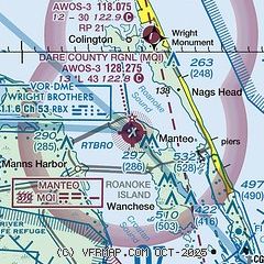
| Sectional chart |
|---|
|
| Airport distance calculator |
|---|
|
|
| Sunrise and sunset |
|---|
|
Times for 06-May-2026
| | Local
(UTC-4) | | Zulu
(UTC) |
|---|
| Morning civil twilight | | 05:38 | | 09:38 |
| Sunrise | | 06:06 | | 10:06 |
| Sunset | | 19:53 | | 23:53 |
| Evening civil twilight | | 20:20 | | 00:20 |
|
| Current date and time |
|---|
| Zulu (UTC) | 06-May-2026 05:11:08 |
|---|
| Local (UTC-4) | 06-May-2026 01:11:08 |
|---|
|
| METAR |
|---|
| KMQI | 060455Z AUTO 22014KT 10SM CLR 19/14 A3005 RMK AO2 T01860135
|
KFFA
6nm N | 060455Z AUTO 20005KT 10SM CLR 19/14 A3003 RMK AO2 T01850142
|
K2DP
17nm SW | 060455Z AUTO 19009KT 10SM CLR 20/15 A3002 RMK AO2 SLP173 T01990147 402770120 $
|
|
| TAF |
|---|
KECG
32nm NW | 051722Z 0518/0618 20015G23KT P6SM SKC FM060100 19012KT P6SM SCT250 FM061300 21013G23KT P6SM OVC100
|
|
| NOTAMs |
|---|
NOTAMs are issued by the DoD/FAA and will open in a separate window not controlled by AirNav.
|
|

