FAA INFORMATION EFFECTIVE 19 MARCH 2026
Location
| FAA Identifier: | X50 |
| Lat/Long: | 28-58-44.1000N 080-55-29.2000W
28-58.735000N 080-55.486667W
28.9789167,-80.9247778
(estimated) |
| Elevation: | 10.6 ft. / 3.2 m (surveyed) |
| Variation: | 07W (2015) |
| From city: | 3 miles S of NEW SMYRNA BEACH, FL |
| Time zone: | UTC -4 (UTC -5 during Standard Time) |
| Zip code: | 32132 |
Airport Operations
| Airport use: | Open to the public |
| Activation date: | 06/1981 |
| Control tower: | no |
| ARTCC: | JACKSONVILLE CENTER |
| FSS: | SAINT PETERSBURG FLIGHT SERVICE STATION |
| NOTAMs facility: | PIE (NOTAM-D service available) |
| Attendance: | MON-FRI 0900-1700, ALL SAT-SUN IREG |
| Wind indicator: | lighted |
| Segmented circle: | no |
| Lights: | SS-SR |
| Landing fee: | yes |
Airport Communications
| CTAF/UNICOM: | 122.7 |
| DAYTONA APPROACH: | 125.35 |
| DAYTONA DEPARTURE: | 125.35 |
| TTHOR STAR: | 118.85 |
| WX AWOS-3 at EVB (5 nm N): | 124.625 (386-409-4705) |
| WX ASOS at DAB (14 nm NW): | PHONE 386-232-5134 |
| WX AWOS-3 at DED (20 nm W): | 119.575 (386-740-5811) |
Nearby radio navigation aids
| VOR radial/distance | | VOR name | | Freq | | Var |
|---|
| OMNr153/21.8 | | ORMOND BEACH VORTAC | | 112.60 | | 00E |
| ORLr040/33.9 | | ORLANDO VORTAC | | 112.20 | | 00E |
Airport Services
| Fuel available: | 100LL JET-A
100LL:SELF SERVICE. |
| Parking: | tiedowns |
| Airframe service: | MAJOR |
| Powerplant service: | MAJOR |
| Bottled oxygen: | NONE |
| Bulk oxygen: | NONE |
Runway Information
Runway 18/36
| Dimensions: | 4360 x 60 ft. / 1329 x 18 m |
| Surface: | asphalt, in fair condition |
| Runway edge lights: | low intensity
RWY 18/36 LIRLS ARE PSND 20 FT EITHER SIDE OF RWY. |
| RUNWAY 18 | | RUNWAY 36 |
| Latitude: | 28-59.092047N | | 28-58.377040N |
| Longitude: | 080-55.531558W | | 080-55.441417W |
| Elevation: | 10.1 ft. | | 9.9 ft. |
| Traffic pattern: | left | | left |
| Runway heading: | 181 magnetic, 174 true | | 001 magnetic, 354 true |
| Displaced threshold: | 315 ft. | | 200 ft. |
| Markings: | nonprecision, in fair condition | | nonprecision, in fair condition |
| Touchdown point: | yes, no lights | | yes, no lights |
| Obstructions: | 17 ft. road, 275 ft. from runway, 125 ft. left of centerline, 4:1 slope to clear
RWY 18 APCH RATIO 20:1 TO DTHR DUE TO TREES 37 FT 510 FT FROM AER 70 FT L OF CNTRLN. | | 15 ft. road, 360 ft. from runway, 125 ft. left of centerline, 10:1 slope to clear
RWY 36 APCH RATIO 20:1 TO DTHR DUE TO TREES 46 FT 710 FT FROM AER 125 FT L OF CNTRLN. |
Airport Ownership and Management from official FAA records
| Ownership: | Privately-owned |
| Owner: | MASSEY RANCH AIRPARK
PO BOX 1947
NEW SMYRA BEACH, FL 32170-1947
Phone 386-427-3100 |
| Manager: | JOHN MASSEY
MASSEY RANCH AIRPARK, PO BOX 1947
NEW SMYRA BEACH, FL 32170-1947
Phone 386-428-3818
AIRPORT PHYSICAL ADDRESS: 635 AIRPORT ROAD EDGEWATER, FL 32132. |
Additional Remarks
| - | GLIDER, BANNER TOWING, AEROBATICS & PARACHUTING ACTIVITY ON & INVOF ARPT. |
| - | ACFT MAINT CALL 386-426-6346. |
| - | FOR CD OR TO CNL IFR CTC DAB APCH AT 386-226-3939. |
Instrument Procedures
NOTE: All procedures below are presented as PDF files. If you need a reader for these files, you should download the free Adobe Reader.NOT FOR NAVIGATION. Please procure official charts for flight.
FAA instrument procedures published for use from 19 March 2026 at 0901Z to 16 April 2026 at 0900Z.
STARs - Standard Terminal Arrivals |
|---|
| TTHOR THREE (RNAV) | |
2 pages:
[1] [2] (334KB) |
IAPs - Instrument Approach Procedures |
|---|
| RNAV (GPS)-A **CHANGED** | |
download (181KB) |
| RNAV (GPS)-B **CHANGED** | |
download (190KB) |
| NOTE: Special Take-Off Minimums/Departure Procedures apply | |
download (238KB) |
Other nearby airports with instrument procedures:
KEVB - New Smyrna Beach Municipal Airport (Jack Bolt Field) (5 nm N)
7FL6 - Spruce Creek Airport (9 nm NW)
KDAB - Daytona Beach International Airport (14 nm NW)
KDED - DeLand Municipal Airport-Sidney H Taylor Field (20 nm W)
KSFB - Orlando Sanford International Airport (20 nm SW)
|
|

Road maps at:
MapQuest
Bing
Google
| Aerial photo |
|---|
WARNING: Photo may not be current or correct
 Photo courtesy of Russell Aerial Photography
Photo taken 07-Mar-2019
looking west.
Photo courtesy of Russell Aerial Photography
Photo taken 07-Mar-2019
looking west.
Do you have a better or more recent aerial photo of Massey Ranch Airpark that you would like to share? If so, please send us your photo.
|
| Sectional chart |
|---|
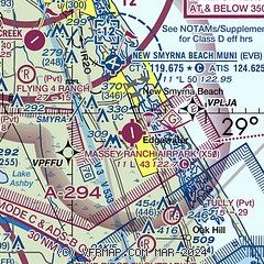
|
| Airport distance calculator |
|---|
|
|
| Sunrise and sunset |
|---|
|
Times for 07-Apr-2026
| | Local
(UTC-4) | | Zulu
(UTC) |
|---|
| Morning civil twilight | | 06:44 | | 10:44 |
| Sunrise | | 07:08 | | 11:08 |
| Sunset | | 19:44 | | 23:44 |
| Evening civil twilight | | 20:08 | | 00:08 |
|
| Current date and time |
|---|
| Zulu (UTC) | 08-Apr-2026 00:07:47 |
|---|
| Local (UTC-4) | 07-Apr-2026 20:07:47 |
|---|
|
| METAR |
|---|
KEVB
5nm N | 072347Z 06025G32KT 10SM SCT032 BKN045 21/17 A3000
|
KDAB
14nm NW | 072353Z 05016G28KT 10SM SCT030 SCT040 OVC120 19/14 A3001 RMK AO2 PK WND 06032/2341 RAE33 SLP162 P0000 60002 T01940144 10200 20178 53012
|
KDED
20nm W | 072355Z AUTO 04005KT 10SM -RA SCT031 SCT044 OVC120 16/16 A3002 RMK AO2 P0002 T01640158 10196 20163 402090163 60010
|
KSFB
20nm SW | 072353Z 06013KT 10SM FEW030 OVC090 19/14 A3000 RMK AO2 PK WND 04026/2255 SLP159 60010 T01890144 10194 20183 53010
|
|
| TAF |
|---|
KDAB
14nm NW | 072048Z 0721/0818 04025G35KT 6SM -RA BR SCT015 BKN025 OVC040 TEMPO 0721/0724 4SM RA BR SCT015 OVC020 FM080300 04025G31KT P6SM VCSH SCT008 BKN015 FM080800 05021G27KT P6SM VCSH SCT008 BKN020 OVC035 FM081200 05023G28KT 4SM -RA BR OVC050 FM081500 06026G31KT 4SM -RA BR OVC015
|
KSFB
20nm SW | 072038Z 0721/0818 02020G28KT 6SM -RA BR BKN015 BKN025 OVC050 FM080000 04022G29KT P6SM SCT008 SCT015 BKN020 PROB30 0803/0805 P6SM -RA OVC015 FM080500 03014KT P6SM VCSH SCT008 OVC015 FM081200 04017KT 4SM -RA BR OVC015 FM081400 05019G25KT 4SM -RA BR OVC015
|
|
| NOTAMs |
|---|
NOTAMs are issued by the DoD/FAA and will open in a separate window not controlled by AirNav.
|
|


