FAA INFORMATION EFFECTIVE 22 JANUARY 2026
Location
| FAA Identifier: | ANE |
| Lat/Long: | 45-08-41.6000N 093-12-36.7000W
45-08.693333N 093-12.611667W
45.1448889,-93.2101944
(estimated) |
| Elevation: | 912.2 ft. / 278.0 m (surveyed) |
| Variation: | 02E (2000) |
| From city: | 10 miles N of MINNEAPOLIS, MN |
| Time zone: | UTC -6 (UTC -5 during Daylight Saving Time) |
| Zip code: | 55449 |
Airport Operations
| Airport use: | Open to the public |
| Activation date: | 11/1952 |
| Control tower: | yes |
| ARTCC: | MINNEAPOLIS CENTER |
| FSS: | PRINCETON FLIGHT SERVICE STATION |
| NOTAMs facility: | ANE (NOTAM-D service available) |
| Attendance: | CONTINUOUS |
| Wind indicator: | lighted |
| Segmented circle: | no |
| Lights: | ACTVT OR INCR INTST MALSR RWY 27; REIL RWY 09, 18, & 36; PAPI RWY 09 & 27; VASI RWY 18 & 36; HIRL RWY 09/27; MIRL RWY 18/36 - CTAF. HIRL RWY 09/27 & MIRL RWY 18/36 PRESET LOW INTST. |
| Beacon: | white-green (lighted land airport)
Operates sunset to sunrise. |
| Landing fee: | yes, LDG FEE FOR TURBINE ACFT. |
Airport Communications
| CTAF: | 132.4 |
| UNICOM: | 122.95 |
| ATIS: | 120.625 |
| WX AWOS-3: | PHONE 763-780-9025 |
| ANOKA GROUND: | 121.85 [0700-2100 OCT-APR; 0700-2200 MAY-SEP] |
| ANOKA TOWER: | 132.4 [0700-2100 OCT-APR; 0700-2200 MAY-SEP] |
| MINNEAPOLIS APPROACH: | 126.5 |
| MINNEAPOLIS DEPARTURE: | 126.5 |
| CLEARANCE DELIVERY: | 121.3 121.3 121.85 ;WHEN TWR CLSD |
| COULT DP: | 126.5 |
| KBREW DP: | 126.5 |
| ORSKY DP: | 126.5 |
| ROCHESTER DP: | 126.5 |
| SCHEP DP: | 126.5 |
| TWOLF STAR: | 126.95 |
| WLSTN DP: | 126.5 |
| ZMBRO DP: | 126.5 |
| WX ASOS at MIC (8 nm SW): | PHONE 763-531-2343 |
| WX ASOS at STP (14 nm SE): | 118.35 (651-312-8888) |
| WX ASOS at MSP (16 nm S): | PHONE 218-203-0160 |
| WX AWOS-3 at 21D (18 nm SE): | 120.075 (651-779-5949) |
| WX AWOS-3 at SGS (19 nm SE): | 119.425 (651-457-8120) |
- MINNEAPOLIS APCH PROVIDES CD ON 121.85 WHEN ANOKA CO-BLAINE ATCT CLSD.
Nearby radio navigation aids
| VOR radial/distance | | VOR name | | Freq | | Var |
|---|
| GEPr084/6.9 | | GOPHER VORTAC | | 117.30 | | 06E |
| MSPr002/14.9 | | MINNEAPOLIS VOR/DME | | 115.30 | | 02E |
| FCMr026/21.6 | | FLYING CLOUD VOR/DME | | 117.70 | | 01E |
| FGTr352/30.9 | | FARMINGTON VORTAC | | 115.70 | | 06E |
Airport Services
| Fuel available: | 100LL JET-A
A:JET A AVBL AT FBOS SUBJ LDG FEE CTC FBO.
100LL:100LL AVBL H24 VIA CREDIT CARD AT LYNX SOUTH RAMP. |
| Parking: | hangars and tiedowns |
| Airframe service: | MAJOR |
| Powerplant service: | MAJOR |
| Bottled oxygen: | HIGH/LOW |
| Bulk oxygen: | NONE |
Runway Information
Runway 9/27
| Dimensions: | 5000 x 100 ft. / 1524 x 30 m |
| Surface: | asphalt/grooved, in good condition |
| Weight bearing capacity: | | Single wheel: | 23.0 | | Double wheel: | 60.0 |
|
| Runway edge lights: | high intensity |
| RUNWAY 9 | | RUNWAY 27 |
| Latitude: | 45-08.689162N | | 45-08.678952N |
| Longitude: | 093-13.204615W | | 093-12.042120W |
| Elevation: | 905.1 ft. | | 908.9 ft. |
| Traffic pattern: | left | | right |
| Runway heading: | 089 magnetic, 091 true | | 269 magnetic, 271 true |
| Markings: | nonprecision, in good condition | | precision, in good condition |
| Visual slope indicator: | 4-light PAPI on left (3.00 degrees glide path) | | 4-light PAPI on left (3.00 degrees glide path) |
| Approach lights: | | | MALSR: 1,400 foot medium intensity approach lighting system with runway alignment indicator lights |
| Runway end identifier lights: | yes | | no |
| Touchdown point: | yes, no lights | | yes, no lights |
| Instrument approach: | | | ILS/DME |
Runway 18/36
| Dimensions: | 4855 x 100 ft. / 1480 x 30 m |
| Surface: | asphalt, in good condition |
| Weight bearing capacity: | | Single wheel: | 23.0 | | Double wheel: | 60.0 |
|
| Runway edge lights: | medium intensity |
| RUNWAY 18 | | RUNWAY 36 |
| Latitude: | 45-09.101340N | | 45-08.302433N |
| Longitude: | 093-12.592790W | | 093-12.606140W |
| Elevation: | 912.2 ft. | | 909.5 ft. |
| Traffic pattern: | right | | left |
| Runway heading: | 179 magnetic, 181 true | | 359 magnetic, 001 true |
| Markings: | nonprecision, in good condition | | nonprecision, in good condition |
| Visual slope indicator: | 4-box VASI on left (3.00 degrees glide path) | | 4-box VASI on left (3.00 degrees glide path) |
| Runway end identifier lights: | yes | | yes |
| Touchdown point: | yes, no lights | | yes, no lights |
Airport Ownership and Management from official FAA records
| Ownership: | Publicly-owned |
| Owner: | METROPOLITAN AIRPORT CMSN
6040 28TH AVENUE S
MINNEAPOLIS, MN 55450-2799
Phone 612-726-8100 |
| Manager: | PHILIP TIEDEMAN
881 AIRPORT ROAD, BOX C1
MINNEAPOLIS, MN 55449-2701
Phone 763-717-0001
PHILIP.TIEDEMAN@MSPMAC.ORG. |
Additional Remarks
| A30A-27 | CALM WIND RWY WHEN ATCT IS CLSD. |
| - | DEER, BIRDS, & WILDLIFE ON & INVOF ARPT. |
| - | VOLUNTARY NOISE ABATEMENT PROCS IN EFCT. SEE ARPT WEBSITE FOR MORE INFO. |
| - | WHEN ATCT IS CLSD SNOW REMOVAL OPRS MNT CTAF. |
Instrument Procedures
NOTE: All procedures below are presented as PDF files. If you need a reader for these files, you should download the free Adobe Reader.NOT FOR NAVIGATION. Please procure official charts for flight.
FAA instrument procedures published for use from 22 January 2026 at 0901Z to 19 February 2026 at 0900z.
Other nearby airports with instrument procedures:
KMIC - Crystal Airport (8 nm SW)
KSTP - St Paul Downtown Airport Holman Field (14 nm SE)
KMSP - Minneapolis-St Paul International/Wold-Chamberlain Airport (16 nm S)
21D - Lake Elmo Airport (18 nm SE)
KSGS - South St Paul Municipal Airport/Richard E Fleming Field (19 nm SE)
|
|

Road maps at:
MapQuest
Bing
Google
| Aerial photo |
|---|
WARNING: Photo may not be current or correct
 Photo by Chris Gabiou
Photo taken 16-Jul-2020
looking north.
Photo by Chris Gabiou
Photo taken 16-Jul-2020
looking north.
Do you have a better or more recent aerial photo of Anoka County/Blaine Airport (Janes Field) that you would like to share? If so, please send us your photo.
|
| Sectional chart |
|---|
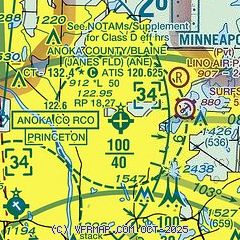
|
 Download PDF
of official airport diagram from the FAA
| Airport distance calculator |
|---|
|
|
| Sunrise and sunset |
|---|
|
Times for 22-Jan-2026
| | Local
(UTC-6) | | Zulu
(UTC) |
|---|
| Morning civil twilight | | 07:12 | | 13:12 |
| Sunrise | | 07:44 | | 13:44 |
| Sunset | | 17:05 | | 23:05 |
| Evening civil twilight | | 17:37 | | 23:37 |
|
| Current date and time |
|---|
| Zulu (UTC) | 22-Jan-2026 23:04:11 |
|---|
| Local (UTC-6) | 22-Jan-2026 17:04:11 |
|---|
|
| METAR |
|---|
| KANE | 222245Z 29022G30KT 10SM SCT026 SCT034 M21/M31 A3031
|
KMIC
8nm SW | 222253Z 30016G31KT 7SM FEW035 M22/M32 A3034 RMK AO2 PK WND 30038/2241 SLP298 T12221317
|
KSTP
14nm SE | 222102Z 30019G30KT 10SM SCT029 SCT041 M17/M26 A3027 RMK AO2 PK WND 30030/2100 T11721261
|
KMSP
16nm S | 222253Z 31019G31KT 9SM FEW027 BKN032 M21/M29 A3034 RMK AO2 PK WND 31033/2200 SLP299 DRSN T12111294 $
|
K21D
17nm SE | 222255Z AUTO 29012G21KT 10SM OVC041 M20/M27 A3031 RMK AO2
|
KSGS
18nm S | 222255Z AUTO 30015G24KT SCT032 SCT041 SCT048 M20/M29 A3033 RMK AO2 T11981295 PWINO
|
|
| TAF |
|---|
KMSP
16nm S | 222138Z 2222/2324 31018G28KT 6SM BLSN SCT025 BKN035 FM230000 31017G27KT P6SM FEW030 FM231300 30009KT P6SM FEW250
|
|
| NOTAMs |
|---|
NOTAMs are issued by the DoD/FAA and will open in a separate window not controlled by AirNav.
|
|


