FAA INFORMATION EFFECTIVE 19 FEBRUARY 2026
Location
| FAA Identifier: | BIV |
| Lat/Long: | 42-44-34.0000N 086-06-28.2000W
42-44.566667N 086-06.470000W
42.7427778,-86.1078333
(estimated) |
| Elevation: | 697.9 ft. / 212.7 m (surveyed) |
| Variation: | 04W (1995) |
| From city: | 2 miles S of HOLLAND, MI |
| Time zone: | UTC -5 (UTC -4 during Daylight Saving Time) |
| Zip code: | 49423 |
Airport Operations
| Airport use: | Open to the public |
| Activation date: | 03/1947 |
| Control tower: | no |
| ARTCC: | CHICAGO CENTER |
| FSS: | LANSING FLIGHT SERVICE STATION |
| NOTAMs facility: | BIV (NOTAM-D service available) |
| Attendance: | MON-FRI 0600-2200, ALL SAT-SUN 0700-2100
FOR ARPT ATNDNC & DURG EMERG CALL 616-392-7831. |
| Wind indicator: | lighted |
| Segmented circle: | yes |
| Lights: | ACTVT OR INCR INTST MALSR RWY 26; REIL RWY 08; PAPI RWY 08 & 26; HIRL RWY 08/26 - CTAF. HIRL RWY 08/26 PRESET LOW INTST. |
| Beacon: | white-green (lighted land airport)
Operates sunset to sunrise. |
| Landing fee: | yes |
Airport Communications
| CTAF/UNICOM: | 123.05 |
| WX ASOS: | 119.025 (616-394-0190) |
| GREAT LAKES APPROACH: | 133.825 |
| GREAT LAKES DEPARTURE: | 133.825 |
| CLEARANCE DELIVERY: | 123.95 |
- APCH/DEP SVC PRVDD BY CHICAGO ARTCC ON FREQS 128.5/273.525 (PULLMAN RCAG) WHEN GREAT LAKES APCH CTL CLSD.
Nearby radio navigation aids
| VOR radial/distance | | VOR name | | Freq | | Var |
|---|
| PMMr360/16.6 | | PULLMAN VOR/DME | | 112.10 | | 00E |
| VIOr268/27.0 | | VICTORY VOR/DME | | 115.95 | | 04W |
Airport Services
| Fuel available: | 100LL JET-A+ |
| Parking: | hangars and tiedowns |
| Airframe service: | MAJOR |
| Powerplant service: | MAJOR |
| Bottled oxygen: | NONE |
| Bulk oxygen: | HIGH/LOW |
Runway Information
Runway 8/26
| Dimensions: | 6002 x 100 ft. / 1829 x 30 m |
| Surface: | asphalt/grooved, in good condition |
| Weight bearing capacity: | | Single wheel: | 75.0 | | Double wheel: | 160.0 | | Double tandem: | 175.0 |
|
| Runway edge lights: | high intensity |
| RUNWAY 8 | | RUNWAY 26 |
| Latitude: | 42-44.478777N | | 42-44.655228N |
| Longitude: | 086-07.129177W | | 086-05.810233W |
| Elevation: | 697.9 ft. | | 685.8 ft. |
| Traffic pattern: | right | | left |
| Runway heading: | 084 magnetic, 080 true | | 264 magnetic, 260 true |
| Markings: | precision, in good condition | | precision, in good condition |
| Visual slope indicator: | 4-light PAPI on left (3.00 degrees glide path) | | 4-light PAPI on left (3.00 degrees glide path) |
| Approach lights: | | | MALSR: 1,400 foot medium intensity approach lighting system with runway alignment indicator lights |
| Runway end identifier lights: | yes | | no |
| Touchdown point: | yes, no lights | | yes, no lights |
| Instrument approach: | | | ILS/DME |
| Obstructions: | 6 ft. tree, 280 ft. from runway, 494 ft. left of centerline, 13:1 slope to clear | | 37 ft. tree, 1297 ft. from runway, 576 ft. left of centerline, 29:1 slope to clear |
Airport Ownership and Management from official FAA records
| Ownership: | Publicly-owned |
| Owner: | CITY OF HOLLAND
60 GEURINK BLVD
HOLLAND, MI 49423-7847
Phone 616-368-3023 |
| Manager: | MATTHEW NEYENS
60 GEURINK BLVD
HOLLAND, MI 49423-7847
Phone 616-414-0726
CELL 248-410-1402. |
Additional Remarks
| - | RADIO CALL, "HOLLAND." |
| - | FOR CD WHEN GREAT LAKES APCH CLSD CTC CHICAGO ARTCC AT 630-906-8921. |
Instrument Procedures
NOTE: All procedures below are presented as PDF files. If you need a reader for these files, you should download the free Adobe Reader.NOT FOR NAVIGATION. Please procure official charts for flight.
FAA instrument procedures published for use from 19 February 2026 at 0901Z to 19 March 2026 at 0900Z.
IAPs - Instrument Approach Procedures |
|---|
| ILS OR LOC RWY 26 | |
download (225KB) |
| RNAV (GPS) RWY 08 | |
download (249KB) |
| RNAV (GPS) RWY 26 | |
download (225KB) |
| NOTE: Special Alternate Minimums apply | |
download (22KB) |
| NOTE: Special Take-Off Minimums/Departure Procedures apply | |
download (122KB) |
Other nearby airports with instrument procedures:
Z98 - Ottawa Executive Airport (9 nm NE)
35D - Padgham Field Airport (18 nm SE)
3GM - Grand Haven Memorial Airpark (18 nm N)
KLWA - South Haven Area Regional Airport (24 nm S)
KMKG - Muskegon County Airport (26 nm N)
|
|

Road maps at:
MapQuest
Bing
Google
| Aerial photo |
|---|
WARNING: Photo may not be current or correct
 Photo by Kevin Jarchow, USCG Auxiliary Air
Photo taken 18-Oct-2015
looking northwest.
Photo by Kevin Jarchow, USCG Auxiliary Air
Photo taken 18-Oct-2015
looking northwest.
Do you have a better or more recent aerial photo of West Michigan Regional Airport that you would like to share? If so, please send us your photo.
|
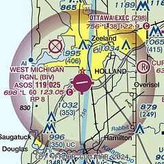
| Sectional chart |
|---|
|
| Airport distance calculator |
|---|
|
|
| Sunrise and sunset |
|---|
|
Times for 04-Mar-2026
| | Local
(UTC-5) | | Zulu
(UTC) |
|---|
| Morning civil twilight | | 06:48 | | 11:48 |
| Sunrise | | 07:16 | | 12:16 |
| Sunset | | 18:36 | | 23:36 |
| Evening civil twilight | | 19:04 | | 00:04 |
|
| Current date and time |
|---|
| Zulu (UTC) | 04-Mar-2026 09:32:27 |
|---|
| Local (UTC-5) | 04-Mar-2026 04:32:27 |
|---|
|
| METAR |
|---|
| KBIV | 040853Z AUTO 00000KT 3SM BR CLR M03/M03 A3022 RMK AO2 SLP243 I1000 I3000 T10281033 50003
|
|
| TAF |
|---|
KMKG
26nm N | 040540Z 0406/0506 00000KT P6SM SKC FM050400 11004KT 6SM BR OVC015
|
KGRR
27nm E | 040540Z 0406/0506 00000KT P6SM FEW250 TEMPO 0406/0408 BKN010 FM041600 11005KT P6SM FEW250 FM050300 11005KT P6SM BKN026 FM050400 VRB04KT P6SM BKN008 FM050500 VRB04KT P6SM BKN004
|
|
| NOTAMs |
|---|
NOTAMs are issued by the DoD/FAA and will open in a separate window not controlled by AirNav.
|
|


