FAA INFORMATION EFFECTIVE 19 FEBRUARY 2026
Location
| FAA Identifier: | RRL |
| Lat/Long: | 45-11-56.1000N 089-42-46.2670W
45-11.935000N 089-42.771117W
45.1989167,-89.7128519
(estimated) |
| Elevation: | 1318.2 ft. / 401.8 m (surveyed) |
| Variation: | 01W (1995) |
| From city: | 1 mile NW of MERRILL, WI |
| Time zone: | UTC -6 (UTC -5 during Daylight Saving Time) |
| Zip code: | 54452 |
Airport Operations
| Airport use: | Open to the public |
| Activation date: | 02/1938 |
| Control tower: | no |
| ARTCC: | MINNEAPOLIS CENTER |
| FSS: | GREEN BAY FLIGHT SERVICE STATION |
| NOTAMs facility: | RRL (NOTAM-D service available) |
| Attendance: | MON-SAT 0800-1700 |
| Wind indicator: | lighted |
| Segmented circle: | yes |
| Lights: | MIRL RWY 07/25 PRESET TO LOW SS-SR; TO INCR INTST & ACTVT REIL RWY 07 & 25; PAPI RWY 07 & 25; MIRL RWY 16/34; - CTAF. |
| Beacon: | white-green (lighted land airport)
Operates sunset to sunrise. |
Airport Communications
| CTAF/UNICOM: | 122.8 |
| WX AWOS-3: | 119.925 (715-539-8422) |
| WX AWOS-3 at TKV (17 nm N): | 118.250 (715-453-5716) |
| WX ASOS at AUW (17 nm S): | 125.925 (715-843-7215) |
- APCH/DEP SVC PRVDD BY MINNEAPOLIS ARTCC ON FREQS 124.4/317.7 (MOSINEE RCAG).
Nearby radio navigation aids
| VOR radial/distance | | VOR name | | Freq | | Var |
|---|
| RHIr200/28.2 | | RHINELANDER VOR/DME | | 115.05 | | 02E |
Airport Services
| Fuel available: | 100LL JET-A+
100LL:FUEL AVBL H24 VIA CREDIT CARD. |
| Parking: | hangars and tiedowns |
| Airframe service: | MAJOR |
| Powerplant service: | MINOR |
| Bottled oxygen: | NONE |
| Bulk oxygen: | NONE |
Runway Information
Runway 7/25
| Dimensions: | 5101 x 75 ft. / 1555 x 23 m |
| Surface: | asphalt, in good condition |
| Weight bearing capacity: | | Single wheel: | 45.0 | | Double wheel: | 65.0 | | Double tandem: | 100.0 |
|
| Runway edge lights: | medium intensity |
| RUNWAY 7 | | RUNWAY 25 |
| Latitude: | 45-11.744610N | | 45-12.051133N |
| Longitude: | 089-43.510223W | | 089-42.405157W |
| Elevation: | 1318.1 ft. | | 1306.2 ft. |
| Traffic pattern: | left | | left |
| Runway heading: | 070 magnetic, 069 true | | 250 magnetic, 249 true |
| Markings: | nonprecision, in good condition | | nonprecision, in good condition |
| Visual slope indicator: | 2-light PAPI on left (3.00 degrees glide path) | | 2-light PAPI on left (3.00 degrees glide path) |
| Runway end identifier lights: | yes | | yes |
| Touchdown point: | yes, no lights | | yes, no lights |
| Obstructions: | 55 ft. trees, 1600 ft. from runway, 230 ft. right of centerline, 25:1 slope to clear | | 35 ft. trees, 1025 ft. from runway, 85 ft. right of centerline, 23:1 slope to clear |
Runway 16/34
| Dimensions: | 2997 x 75 ft. / 913 x 23 m |
| Surface: | asphalt, in fair condition |
| Weight bearing capacity: | |
| Runway edge lights: | medium intensity |
| RUNWAY 16 | | RUNWAY 34 |
| Latitude: | 45-12.224217N | | 45-11.772010N |
| Longitude: | 089-42.592837W | | 089-42.314378W |
| Elevation: | 1317.7 ft. | | 1303.4 ft. |
| Traffic pattern: | left | | left |
| Runway heading: | 157 magnetic, 156 true | | 337 magnetic, 336 true |
| Markings: | basic, in fair condition | | basic, in fair condition |
| Runway end identifier lights: | no | | no |
| Touchdown point: | yes, no lights | | yes, no lights |
| Obstructions: | none | | 83 ft. trees, 1775 ft. from runway, 150 ft. left of centerline, 18:1 slope to clear |
Airport Ownership and Management from official FAA records
| Ownership: | Publicly-owned |
| Owner: | CITY OF MERRILL
N2241 AIRPORT RD
MERRILL, WI 54452
Phone 715-536-2024 |
| Manager: | RICH MCCULLOUGH
N2241 AIRPORT RD
MERRILL, WI 54452
Phone 715-536-2024 |
Additional Remarks
| - | ULTRALIGHT ACT ON & INVOF ARPT. |
| - | FOR CD CTC MINNEAPOLIS ARTCC AT 651-463-5588. |
Instrument Procedures
NOTE: All procedures below are presented as PDF files. If you need a reader for these files, you should download the free Adobe Reader.NOT FOR NAVIGATION. Please procure official charts for flight.
FAA instrument procedures published for use from 19 February 2026 at 0901Z to 19 March 2026 at 0900Z.
IAPs - Instrument Approach Procedures |
|---|
| RNAV (GPS) RWY 07 **CHANGED** | |
download (211KB) |
| RNAV (GPS) RWY 25 **CHANGED** | |
download (213KB) |
| NOTE: Special Alternate Minimums apply | |
download (51KB) |
| NOTE: Special Take-Off Minimums/Departure Procedures apply | |
download (201KB) |
Other nearby airports with instrument procedures:
KTKV - Tomahawk Regional Airport (17 nm N)
KAUW - Wausau Downtown Airport (17 nm S)
KCWA - Central Wisconsin Airport (25 nm S)
KMDZ - Taylor County Airport (26 nm W)
KAIG - Langlade County Airport (26 nm E)
|
|

Road maps at:
MapQuest
Bing
Google
| Aerial photo |
|---|
WARNING: Photo may not be current or correct
 Photo by Karen Krueger
Taken in July 2015
looking east-northeast.
Photo by Karen Krueger
Taken in July 2015
looking east-northeast.
Do you have a better or more recent aerial photo of Merrill Municipal Airport that you would like to share? If so, please send us your photo.
|
| Sectional chart |
|---|
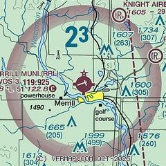
|
| Airport distance calculator |
|---|
|
|
| Sunrise and sunset |
|---|
|
Times for 11-Mar-2026
| | Local
(UTC-5) | | Zulu
(UTC) |
|---|
| Morning civil twilight | | 06:50 | | 11:50 |
| Sunrise | | 07:20 | | 12:20 |
| Sunset | | 18:58 | | 23:58 |
| Evening civil twilight | | 19:27 | | 00:27 |
|
| Current date and time |
|---|
| Zulu (UTC) | 11-Mar-2026 15:27:44 |
|---|
| Local (UTC-5) | 11-Mar-2026 10:27:44 |
|---|
|
| METAR |
|---|
| KRRL | 111515Z AUTO 36011G18KT BKN014 BKN028 OVC035 M02/M04 A2985 RMK AO2 T10161043 PWINO TSNO
|
KAUW
16nm S | 111508Z AUTO 32010KT 2SM -SN BR FEW016 BKN023 OVC031 M02/M04 A2984 RMK AO2 P0000 T10171039
|
KTKV
17nm N | 111515Z 1 1/4SM BKN007 OVC011 M02/M03 A2987 RMK AO2 T10161032 PWINO
|
|
| TAF |
|---|
KAUW
16nm S | 111352Z 1114/1212 36010G19KT 2SM -SN BR OVC012 FM111600 35013G22KT 4SM -SN OVC015 FM111800 34014G23KT P6SM OVC024 FM112000 32011G19KT P6SM SCT120 FM120300 30005KT P6SM SKC
|
|
| NOTAMs |
|---|
NOTAMs are issued by the DoD/FAA and will open in a separate window not controlled by AirNav.
|
|

