FAA INFORMATION EFFECTIVE 09 JULY 2026
Location
| FAA Identifier: | SIK |
| Lat/Long: | 36-53-56.0000N 089-33-42.3000W
36-53.933333N 089-33.705000W
36.8988889,-89.5617500
(estimated) |
| Elevation: | 314.8 ft. / 96.0 m (surveyed) |
| Variation: | 02W (2015) |
| From city: | 2 miles NE of SIKESTON, MO |
| Time zone: | UTC -5 (UTC -6 during Standard Time) |
| Zip code: | 63801 |
Airport Operations
| Airport use: | Open to the public |
| Activation date: | 04/1940 |
| Control tower: | no |
| ARTCC: | MEMPHIS CENTER |
| FSS: | SAINT LOUIS FLIGHT SERVICE STATION |
| NOTAMs facility: | STL (NOTAM-D service available) |
| Attendance: | 0800-1700 |
| Wind indicator: | lighted |
| Segmented circle: | yes |
| Lights: | MIRL RWY 03/21 PRESET ON LOW INTST; TO INCR INTST AND ACTVT REIL RWY 21 - CTAF. PAPI RWYS 03 & 21 OPER CONTINUOUSLY. |
| Beacon: | white-green (lighted land airport)
Operates sunset to sunrise. |
Airport Communications
| CTAF/UNICOM: | 122.8 |
| WX AWOS-3PT: | 119.175 (573-471-2736) |
| WX AWOS-3 at CIR (19 nm NE): | 118.025 (618-734-9173) |
| WX ASOS at CGI (20 nm N): | 120.55 (573-335-3811) |
- APCH/DEP SVC PRVDD BY MEMPHIS ARTCC ON FREQS 133.65/292.15 (PADUCAH RCAG).
Nearby radio navigation aids
| VOR radial/distance | | VOR name | | Freq | | Var |
|---|
| CNGr256/35.4 | | CUNNINGHAM VOR/DME | | 113.10 | | 03E |
Airport Services
| Fuel available: | 100LL JET-A
100LL:24-HR AUTOMATIC CREDIT CARD FUELING SYSTEM FOR 100LL. |
| Parking: | hangars and tiedowns |
| Bottled oxygen: | NONE |
| Bulk oxygen: | NONE |
Runway Information
Runway 3/21
| Dimensions: | 5502 x 100 ft. / 1677 x 30 m |
| Surface: | asphalt, in good condition |
| Weight bearing capacity: | | Single wheel: | 76.0 | | Double wheel: | 96.0 | | Double tandem: | 152.0 |
|
| Runway edge lights: | medium intensity |
| Runway edge markings: | RWY 21 MARKINGS SEVERELY FADED |
| RUNWAY 3 | | RUNWAY 21 |
| Latitude: | 36-53.518420N | | 36-54.346962N |
| Longitude: | 089-33.934268W | | 089-33.475742W |
| Elevation: | 313.0 ft. | | 314.2 ft. |
| Traffic pattern: | left | | left |
| Runway heading: | 026 magnetic, 024 true | | 206 magnetic, 204 true |
| Markings: | nonprecision, in poor condition | | nonprecision, in poor condition |
| Visual slope indicator: | 4-light PAPI on left (3.00 degrees glide path) | | 4-light PAPI on left (3.00 degrees glide path) |
| Runway end identifier lights: | | | yes |
| Touchdown point: | yes, no lights | | yes, no lights |
| Obstructions: | 25 ft. tree, 1030 ft. from runway, 270 ft. left of centerline, 33:1 slope to clear | | 35 ft. trees, 1225 ft. from runway, 358 ft. left of centerline, 29:1 slope to clear |
Airport Ownership and Management from official FAA records
| Ownership: | Publicly-owned |
| Owner: | CITY OF SIKESTON
105 E CENTER
SIKESTON, MO 63801
Phone 573-471-2512 |
| Manager: | SIKESTON AVIATION
160 AIRPORT DR
SIKESTON, MO 63801
Phone 573-471-2037 |
Additional Remarks
| A39-03/21 | PCR VALUE: 310/F/D/X/T |
| A96 | ULTRALIGHT ACTIVITY ON & INVOF ARPT. |
| - | NUMEROUS BIRDS INVOF ARPT. |
| - | FOR CD CTC MEMPHIS ARTCC AT 901-368-8453/8449. |
Instrument Procedures
NOTE: All procedures below are presented as PDF files. If you need a reader for these files, you should download the free Adobe Reader.NOT FOR NAVIGATION. Please procure official charts for flight.
FAA instrument procedures published for use from 09 July 2026 at 0901Z to 06 August 2026 at 0900Z.
IAPs - Instrument Approach Procedures |
|---|
| RNAV (GPS) RWY 03 | |
download (228KB) |
| RNAV (GPS) RWY 21 | |
download (244KB) |
| NOTE: Special Take-Off Minimums/Departure Procedures apply | |
download (421KB) |
Other nearby airports with instrument procedures:
KCHQ - Mississippi County Airport (10 nm E)
KCIR - Cairo Regional Airport (19 nm NE)
KCGI - Cape Girardeau Regional Airport (20 nm N)
KDXE - Dexter Municipal Airport (20 nm W)
KEIW - County Memorial Airport (22 nm S)
|
|

Road maps at:
MapQuest
Bing
Google
| Aerial photo |
|---|
WARNING: Photo may not be current or correct
 Photo by Kris Greene, City of Sikeston
Photo taken 07-Jan-2010
looking east.
Photo by Kris Greene, City of Sikeston
Photo taken 07-Jan-2010
looking east.
Do you have a better or more recent aerial photo of Sikeston Memorial Municipal Airport that you would like to share? If so, please send us your photo.
|
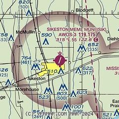
| Sectional chart |
|---|
|
| Airport distance calculator |
|---|
|
|
| Sunrise and sunset |
|---|
|
Times for 24-Jul-2026
| | Local
(UTC-5) | | Zulu
(UTC) |
|---|
| Morning civil twilight | | 05:29 | | 10:29 |
| Sunrise | | 05:58 | | 10:58 |
| Sunset | | 20:11 | | 01:11 |
| Evening civil twilight | | 20:40 | | 01:40 |
|
| Current date and time |
|---|
| Zulu (UTC) | 25-Jul-2026 04:53:02 |
|---|
| Local (UTC-5) | 24-Jul-2026 23:53:02 |
|---|
|
| METAR |
|---|
| KSIK | 250435Z AUTO 06003KT 9SM FEW120 BKN160 22/22 A3006 RMK AO2 T02170217 $
|
KCIR
19nm NE | 250435Z AUTO 00000KT 10SM BKN110 23/22 A3009 RMK AO2 T02250216
|
|
| TAF |
|---|
KCGI
20nm N | 241740Z 2418/2518 06003KT P6SM VCSH SCT080 BKN150 PROB30 2508/2514 6SM -SHRA BKN035 FM251400 19005KT P6SM BKN035 PROB30 2514/2518 6SM -SHRA OVC025
|
|
| NOTAMs |
|---|
NOTAMs are issued by the DoD/FAA and will open in a separate window not controlled by AirNav.
|
|

