FAA INFORMATION EFFECTIVE 21 MARCH 2024
Location
| FAA Identifier: | T82 |
| Lat/Long: | 30-14-35.7000N 098-54-33.1000W
30-14.595000N 098-54.551667W
30.2432500,-98.9091944
(estimated) |
| Elevation: | 1694.7 ft. / 516.5 m (surveyed) |
| Variation: | 06E (2005) |
| From city: | 3 miles SW of FREDERICKSBURG, TX |
| Time zone: | UTC -5 (UTC -6 during Standard Time) |
| Zip code: | 78624 |
Airport Operations
| Airport use: | Open to the public |
| Activation date: | 03/1947 |
| Control tower: | no |
| ARTCC: | HOUSTON CENTER |
| FSS: | SAN ANGELO FLIGHT SERVICE STATION |
| NOTAMs facility: | T82 (NOTAM-D service available) |
| Attendance: | 0800-1800 |
| Wind indicator: | lighted |
| Segmented circle: | yes |
| Lights: | MIRL RWY 14/32 ACTVT - CTAF (5 CLICKS - LOW INTST, 7 CLICKS - MED INTST). |
| Beacon: | white-green (lighted land airport)
Operates sunset to sunrise. |
Airport Communications
| CTAF/UNICOM: | 122.7 |
| WX AWOS-3: | 120.0 (830-990-2716) |
| WX AWOS-3 at ERV (18 nm SW): | 118.125 (830-895-2204) |
- APCH/DEP CTL SVC PRVDD BY HOUSTON ARTCC (ZHU) ON FREQS 134.2/307.3 (FREDERICKSBURG RCAG).
Nearby radio navigation aids
| VOR radial/distance | | VOR name | | Freq | | Var |
|---|
| STVr274/10.8 | | STONEWALL VORTAC | | 113.80 | | 08E |
| CSIr031/24.9 | | CENTER POINT VORTAC | | 117.50 | | 08E |
| LLOr183/33.8 | | LLANO VORTAC | | 108.20 | | 08E |
Airport Services
| Fuel available: | 100LL JET-A
100LL:FUEL 24 HR SELF SERVE. |
| Parking: | tiedowns |
| Airframe service: | MAJOR |
| Powerplant service: | MAJOR |
| Bottled oxygen: | NONE |
| Bulk oxygen: | NONE |
Runway Information
Runway 14/32
| Dimensions: | 5001 x 75 ft. / 1524 x 23 m |
| Surface: | asphalt, in good condition |
| Weight bearing capacity: | | PCN 21 /F/C/X/T | | Single wheel: | 30.0 |
|
| Runway edge lights: | medium intensity |
| RUNWAY 14 | | RUNWAY 32 |
| Latitude: | 30-14.939530N | | 30-14.249640N |
| Longitude: | 098-54.811783W | | 098-54.290662W |
| Elevation: | 1694.6 ft. | | 1677.1 ft. |
| Traffic pattern: | right | | left |
| Runway heading: | 141 magnetic, 147 true | | 321 magnetic, 327 true |
| Markings: | nonprecision, in fair condition | | nonprecision, in fair condition |
| Visual slope indicator: | 2-light PAPI on left (3.00 degrees glide path) | | 2-light PAPI on left (3.00 degrees glide path) |
| Touchdown point: | yes, no lights | | yes, no lights |
| Obstructions: | 3 ft. fence, lighted, 200 ft. from runway, 216 ft. right of centerline
RWY 14 +3 FT FENCE 190-200 FT FM THR, 216 FT RIGHT. | | 12 ft. road, 357 ft. from runway, 250 ft. right of centerline, 13:1 slope to clear |
Airport Ownership and Management from official FAA records
| Ownership: | Publicly-owned |
| Owner: | GILLESPIE COUNTY
101 W MAIN
FREDERICKSBURG, TX 78624
Phone 830-997-7502 |
| Manager: | TONY LOMBARDI
101 W MAIN UNIT 9
FREDERICKSBURG, TX 78624
Phone 830-990-5764 |
Airport Operational Statistics
| Aircraft based on the field: | | 100 | | Single engine airplanes: | | 87 | | Multi engine airplanes: | | 7 | | Jet airplanes: | | 4 | | Helicopters: | | 2 |
| |  | |
| Aircraft operations: avg 41/day * | | 49% | transient general aviation | | 49% | local general aviation | | 1% | military | | * for 12-month period ending 02 June 2023 | |
Additional Remarks
| - | 75 FT TANK 300 FT SE OF ROTG BCN. |
| - | GCO AVBL ON FREQ 121.725 THRU HOUSTON ARTCC - 6 CLICKS; FSS - 4 CLICKS. |
| - | FBO 830-997-3313. |
| - | SEASONAL FFR AIR OPNS IN AND OUT OF ARPT. |
| - | FOR CD IF UNA VIA GCO CTC HOUSTON ARTCC AT 281-230-5622. |
Instrument Procedures
NOTE: All procedures below are presented as PDF files. If you need a reader for these files, you should download the free Adobe Reader.NOT FOR NAVIGATION. Please procure official charts for flight.
FAA instrument procedures published for use from 21 March 2024 at 0901Z to 18 April 2024 at 0900z.
IAPs - Instrument Approach Procedures |
|---|
| RNAV (GPS) RWY 14 | |
download (185KB) |
| RNAV (GPS) RWY 32 | |
download (213KB) |
| VOR/DME-A | |
download (166KB) |
| NOTE: Special Alternate Minimums apply | |
download (116KB) |
| NOTE: Special Take-Off Minimums/Departure Procedures apply | |
download (210KB) |
Other nearby airports with instrument procedures:
KERV - Kerrville Municipal Airport/Louis Schreiner Field (18 nm SW)
T92 - Mason County Airport (33 nm NW)
5C1 - Boerne Stage Airfield (33 nm S)
KAQO - Llano Municipal Airport (35 nm N)
KBMQ - Burnet Municipal Airport/Kate Craddock Field (46 nm NE)
|
|

Road maps at:
MapQuest
Bing
Google
| Aerial photo |
|---|
WARNING: Photo may not be current or correct
 Photo taken 30-Aug-2017
looking north.
Photo taken 30-Aug-2017
looking north.
Do you have a better or more recent aerial photo of Gillespie County Airport that you would like to share? If so, please send us your photo.
|
| Sectional chart |
|---|
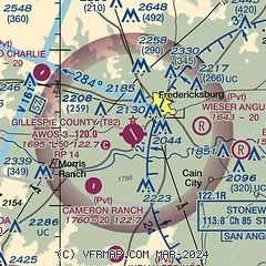
|
CAUTION: Diagram may not be current

| Airport distance calculator |
|---|
|
|
| Sunrise and sunset |
|---|
|
Times for 18-Apr-2024
| | Local
(UTC-5) | | Zulu
(UTC) |
|---|
| Morning civil twilight | | 06:40 | | 11:40 |
| Sunrise | | 07:05 | | 12:05 |
| Sunset | | 20:04 | | 01:04 |
| Evening civil twilight | | 20:29 | | 01:29 |
|
| Current date and time |
|---|
| Zulu (UTC) | 18-Apr-2024 10:50:15 |
|---|
| Local (UTC-5) | 18-Apr-2024 05:50:15 |
|---|
|
| METAR |
|---|
| KT82 | 181035Z AUTO 19005KT 7SM OVC009 21/20 A2993 RMK AO2 T02110195
|
KERV
18nm SW | 181035Z AUTO 17005KT 7SM OVC006 21/20 A2993 RMK AO2 T02130200
|
|
| TAF |
|---|
KJCT
47nm W | 180520Z 1806/1906 15010KT P6SM BKN015 FM181600 20010KT P6SM SCT035 FM190000 04012G22KT P6SM VCTS BKN050CB
|
KSAT
48nm SE | 180933Z 1810/1912 14004KT 3SM BR OVC006 TEMPO 1810/1814 2SM -DZ BR OVC003 FM181600 16007KT P6SM BKN015 BKN200 FM181900 15008KT P6SM SCT040 SCT250 PROB30 1902/1906 -TSRA BKN050CB FM190700 11005KT P6SM BKN008
|
|
| NOTAMs |
|---|
NOTAMs are issued by the DoD/FAA and will open in a separate window not controlled by AirNav.
|
|


