FAA INFORMATION EFFECTIVE 16 APRIL 2026
Location
| FAA Identifier: | TDZ |
| Lat/Long: | 41-33-53.8000N 083-28-56.0000W
41-33.896667N 083-28.933333W
41.5649444,-83.4822222
(estimated) |
| Elevation: | 622.7 ft. / 189.8 m (surveyed) |
| Variation: | 07W (2010) |
| From city: | 6 miles SE of TOLEDO, OH |
| Time zone: | UTC -4 (UTC -5 during Standard Time) |
| Zip code: | 43447 |
Airport Operations
| Airport use: | Open to the public |
| Activation date: | 10/1937 |
| Control tower: | no |
| ARTCC: | CLEVELAND CENTER |
| FSS: | CLEVELAND FLIGHT SERVICE STATION |
| NOTAMs facility: | TDZ (NOTAM-D service available) |
| Attendance: | MON-SAT 0800-1800, ALL SUN 0800-1700 |
| Wind indicator: | lighted |
| Segmented circle: | no |
| Lights: | ACTVT REIL RWY 04, 22, & 14; PAPI RWY 04, 22, 14, & 32; MIRL RWY 04/22 & 14/32 - CTAF. |
| Beacon: | white-green (lighted land airport)
Operates sunset to sunrise. |
| Landing fee: | yes |
Airport Communications
| CTAF/UNICOM: | 123.05 |
| WX ASOS: | 121.575 (419-838-5034) |
| TOLEDO APPROACH: | 126.1 |
| TOLEDO DEPARTURE: | 126.1 |
| CLEARANCE DELIVERY: | 125.6 |
| WX AWOS-3 at 1G0 (12 nm SW): | 120.725 (419-354-1415) |
| WX AWOS-3P at DUH (13 nm NW): | 119.175 (734-856-1563) |
| WX ASOS at TOL (15 nm W): | PHONE 419-210-1094 |
Nearby radio navigation aids
| VOR radial/distance | | VOR name | | Freq | | Var |
|---|
| CRLr185/29.0 | | CARLETON VOR/DME | | 115.70 | | 03W |
| FBCr021/38.6 | | FLAG CITY VORTAC | | 108.20 | | 02W |
| DXOr194/39.2 | | DETROIT VOR/DME | | 113.40 | | 06W |
| NDB name | | Hdg/Dist | | Freq | | Var | | ID |
|---|
| TIFFIN | | 342/30.7 | | 269 | | 05W | | TII | - .. .. |
| ADRIAN | | 130/32.3 | | 278 | | 06W | | ADG | .- -.. --. |
Airport Services
| Fuel available: | 100LL JET-A
A:JET A AVBL SELF SVC OR FULL SVC.
100LL:100LL AVBL SELF SVC OR FULL SVC. |
| Parking: | hangars and tiedowns |
| Airframe service: | MAJOR |
| Powerplant service: | MAJOR |
| Bottled oxygen: | HIGH |
| Bulk oxygen: | HIGH |
Runway Information
Runway 14/32
| Dimensions: | 5829 x 100 ft. / 1777 x 30 m |
| Surface: | asphalt/grooved, in fair condition |
| Weight bearing capacity: | | Single wheel: | 63.0 | | Double wheel: | 85.0 |
|
| Runway edge lights: | medium intensity |
| RUNWAY 14 | | RUNWAY 32 |
| Latitude: | 41-34.263717N | | 41-33.596347N |
| Longitude: | 083-29.406250W | | 083-28.487727W |
| Elevation: | 621.8 ft. | | 621.0 ft. |
| Traffic pattern: | left | | left |
| Runway heading: | 141 magnetic, 134 true | | 321 magnetic, 314 true |
| Displaced threshold: | 225 ft. | | 351 ft. |
| Declared distances: | TORA:5829 TODA:5829 ASDA:5182 LDA:4957 | | TORA:5829 TODA:5829 ASDA:5278 LDA:4927 |
| Markings: | nonprecision, in fair condition | | nonprecision, in fair condition |
| Visual slope indicator: | 4-light PAPI on left (3.00 degrees glide path) | | 4-light PAPI on left (3.00 degrees glide path) |
| Runway end identifier lights: | yes | | no |
| Touchdown point: | yes, no lights | | yes, no lights |
| Obstructions: | 45 ft. tower, 709 ft. from runway, 163 ft. right of centerline, 11:1 slope to clear
APCH RATIO 20:1 TO DTHR. | | 17 ft. road, 352 ft. from runway, 273 ft. right of centerline, 8:1 slope to clear
APCH RATIO 17:1 TO DTHR OVR +31 FT TREE, 538 FT DIST, 299 FT L. |
Runway 4/22
| Dimensions: | 3799 x 75 ft. / 1158 x 23 m |
| Surface: | asphalt, in good condition |
| Weight bearing capacity: | | Single wheel: | 63.0 | | Double wheel: | 85.0 |
|
| Runway edge lights: | medium intensity |
| RUNWAY 4 | | RUNWAY 22 |
| Latitude: | 41-33.601612N | | 41-34.089233N |
| Longitude: | 083-29.175185W | | 083-28.653337W |
| Elevation: | 622.7 ft. | | 620.5 ft. |
| Traffic pattern: | left | | left |
| Runway heading: | 046 magnetic, 039 true | | 226 magnetic, 219 true |
| Displaced threshold: | 100 ft. | | 380 ft. |
| Markings: | nonprecision, in good condition | | nonprecision, in good condition |
| Visual slope indicator: | 4-light PAPI on left (3.50 degrees glide path) | | 4-light PAPI on left (3.00 degrees glide path) |
| Runway end identifier lights: | yes | | yes |
| Touchdown point: | yes, no lights | | yes, no lights |
| Obstructions: | 15 ft. road, 412 ft. from runway, 280 ft. right of centerline, 14:1 slope to clear
APCH RATIO 20:1 TO DTHR. | | 29 ft. rr, 393 ft. from runway, 144 ft. left of centerline, 6:1 slope to clear
APCH RATIO 20:1 TO DTHR. |
Airport Ownership and Management from official FAA records
| Ownership: | Publicly-owned |
| Owner: | TOLEDO LUCAS COUNTY PORT AUTHORITY
1 MARITIME PLZ
TOLEDO, OH 43604-1893
Phone 419-243-8251 |
| Manager: | CHRIS CURRY
11013 AIRPORT HWY STE 11
SWANTON, OH 43558-9403
Phone 419-243-8251
ARPT PHYS ADS: 28331 LEMOYNE RD, MILLBURY, OH 43447. |
Additional Remarks
| - | PARL TWY RWY 04/22 & 14/32 35 FT WID. |
| - | DEER & COYOTES ON & INVOF ARPT. |
| - | FOR CD CTC TOLEDO APCH AT 419-865-1495. |
Instrument Procedures
NOTE: All procedures below are presented as PDF files. If you need a reader for these files, you should download the free Adobe Reader.NOT FOR NAVIGATION. Please procure official charts for flight.
FAA instrument procedures published for use from 16 April 2026 at 0901Z to 14 May 2026 at 0900Z.
IAPs - Instrument Approach Procedures |
|---|
| RNAV (GPS) RWY 04 | |
download (214KB) |
| RNAV (GPS) RWY 32 | |
download (233KB) |
| NOTE: Special Alternate Minimums apply | |
download (143KB) |
| NOTE: Special Take-Off Minimums/Departure Procedures apply | |
download (459KB) |
Other nearby airports with instrument procedures:
1G0 - Wood County Airport (12 nm SW)
KDUH - Toledo Suburban Airport (13 nm NW)
KTOL - Eugene F Kranz Toledo Express Airport (15 nm W)
14G - Fremont Airport (20 nm SE)
KTTF - Custer Airport (23 nm N)
|
|

Road maps at:
MapQuest
Bing
Google
| Aerial photo |
|---|
WARNING: Photo may not be current or correct
 Photo taken 12-Oct-2010
looking north.
Photo taken 12-Oct-2010
looking north.
Do you have a better or more recent aerial photo of Toledo Executive Airport that you would like to share? If so, please send us your photo.
|
| Sectional chart |
|---|
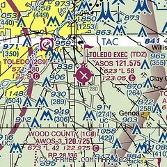
|
| Airport distance calculator |
|---|
|
|
| Sunrise and sunset |
|---|
|
Times for 14-May-2026
| | Local
(UTC-4) | | Zulu
(UTC) |
|---|
| Morning civil twilight | | 05:45 | | 09:45 |
| Sunrise | | 06:17 | | 10:17 |
| Sunset | | 20:44 | | 00:44 |
| Evening civil twilight | | 21:16 | | 01:16 |
|
| Current date and time |
|---|
| Zulu (UTC) | 14-May-2026 04:56:30 |
|---|
| Local (UTC-4) | 14-May-2026 00:56:30 |
|---|
|
| METAR |
|---|
| KTDZ | 140353Z AUTO 31007KT 10SM OVC041 08/03 A2999 RMK AO2 SLP156 T00780028
|
KDUH
13nm NW | 140435Z AUTO 30003KT 10SM OVC041 08/03 A2998 RMK AO2
|
KTOL
14nm W | 140352Z 29008KT 10SM FEW028 OVC036 08/03 A2999 RMK AO2 SLP156 T00780028 $
|
|
| TAF |
|---|
KTOL
14nm W | 131728Z 1318/1418 28012G22KT P6SM OVC035 FM140000 33012KT P6SM OVC025 FM140500 33008KT P6SM OVC035 FM141500 35015G23KT P6SM BKN050
|
|
| NOTAMs |
|---|
NOTAMs are issued by the DoD/FAA and will open in a separate window not controlled by AirNav.
|
|


