FAA INFORMATION EFFECTIVE 22 JANUARY 2026
Location
| FAA Identifier: | 18TE |
| Lat/Long: | 32-35-06.7080N 095-03-50.0920W
32-35.111800N 095-03.834867W
32.5851967,-95.0639144
(estimated) |
| Elevation: | 390 ft. / 118.9 m (surveyed) |
| Variation: | 04E (1965) |
| From city: | 2 miles E of BIG SANDY, TX |
| Time zone: | UTC -6 (UTC -5 during Daylight Saving Time) |
| Zip code: | 75755 |
Airport Operations
| Airport use: | Private use. Permission required prior to landing |
| Activation date: | 04/1965 |
| Control tower: | no |
| ARTCC: | FORT WORTH CENTER |
| FSS: | FORT WORTH FLIGHT SERVICE STATION |
| Attendance: | UNATNDD |
| Wind indicator: | yes, UNLIT WINDSOCK AT EACH END OF RWY. |
| Segmented circle: | no |
| Lights: | PILOT CONTROLLED LIRL RWY 8/26. TO ACTVT - 5 CLICKS ON RADIO (15 MIN TIMER) - 122.8. |
| Beacon: | white-green (lighted land airport)
PILOT CONTROLLED BEACON. TO ACTVT - 5 CLICKS ON RADIO (15 MIN TIMER) - 122.8. |
Airport Communications
| UNICOM: | 122.8 |
| WX AWOS-3PT at JXI (9 nm NE): | 120.250 (903-734-7313) |
Nearby radio navigation aids
| VOR radial/distance | | VOR name | | Freq | | Var |
|---|
| GGGr296/18.7 | | GREGG COUNTY VORTAC | | 112.90 | | 07E |
| TYRr045/22.0 | | TYLER VOR/DME | | 114.20 | | 06E |
| FZTr032/38.7 | | FRANKSTON VOR/DME | | 111.40 | | 06E |
| NDB name | | Hdg/Dist | | Freq | | Var | | ID |
|---|
| AMBASSADOR | | 083/2.5 | | 404 | | 07E | | ABG | .- -... --. |
Airport Services
| Airframe service: | NONE |
| Powerplant service: | NONE |
Runway Information
Runway 8/26
| Dimensions: | 5093 x 45 ft. / 1552 x 14 m |
| Surface: | asphalt, in good condition |
| Runway edge lights: | non-standard
NSTD LIRL; ONLY WESTERN 2/3 OF RWY LGTD. NO TWY LGTS. |
| RUNWAY 8 | | RUNWAY 26 |
| Latitude: | 32-35.118233N | | 32-35.105067N |
| Longitude: | 095-04.331450W | | 095-03.339467W |
| Elevation: | 359.0 ft. | | 349.0 ft. |
| Traffic pattern: | left | | left |
| Runway heading: | 087 magnetic, 091 true | | 267 magnetic, 271 true |
| Markings: | basic, in good condition | | basic, in good condition |
| Touchdown point: | yes, no lights | | yes, no lights |
| Obstructions: | 30 ft. trees, 200 ft. from runway, 100 ft. right of centerline
+30 FT TREES AT THR, 100 FT RIGHT. | | 50 ft. trees, 203 ft. from runway
+10 FT ROAD AT 146 FT, ACRS APCH. |
Airport Ownership and Management from official FAA records
| Ownership: | Privately-owned |
| Owner: | INSTITUTE IN BASIC LIFE PRINCIPLES
BOX 1
OAK BROOK, IL 60522-3001
Phone (479) 799-8999 |
| Manager: | DAKOTA EYER
1 ACADEMY BLVD
BIG SANDY, TX 75755
Phone 570-854-5325 |
Additional Remarks
| - | CAUTION: ROAD INTERSECTS CNTR OF RWY 2507 FT FM THR OF RWY 8. RWY GATES MUST BE LOWERED FOR LNDG. TO ACTVT GATES: 7 CLICKS DOWN (2 MIN TIMER), AND 9 CLICKS UP. |
| - | FOR CD CTC FORT WORTH ARTCC - 817-858-7584 |
| - | FOR PMSN TO LND, CTC DIR OF OPNS AT 903-636-2012. |
| - | RWY CRESTS AT MID AND SLOPES DOWNWARD TWD EACH END. ACFT LNDG RWY 26 MAY WANT TO TOUCHDOWN PAST HNGR TWY TO AVOID UPSLOPE. |
Instrument Procedures
There are no published instrument procedures at 18TE.
Some nearby airports with instrument procedures:
07F - Gladewater Municipal Airport (6 nm SE)
KJXI - Fox Stephens Field/Gilmer Municipal Airport (9 nm NE)
KGGG - East Texas Regional Airport (22 nm SE)
KTYR - Tyler Pounds Regional Airport (22 nm SW)
KJDD - Wood County Airport/Collins Field (24 nm NW)
|
|

Road maps at:
MapQuest
Bing
Google
| Aerial photo |
|---|
WARNING: Photo may not be current or correct

Do you have a better or more recent aerial photo of ALERT Field Airport that you would like to share? If so, please send us your photo.
|
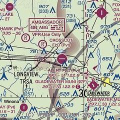
| Sectional chart |
|---|
|
| Airport distance calculator |
|---|
|
|
| Sunrise and sunset |
|---|
|
Times for 18-Feb-2026
| | Local
(UTC-6) | | Zulu
(UTC) |
|---|
| Morning civil twilight | | 06:36 | | 12:36 |
| Sunrise | | 07:01 | | 13:01 |
| Sunset | | 18:07 | | 00:07 |
| Evening civil twilight | | 18:32 | | 00:32 |
|
| Current date and time |
|---|
| Zulu (UTC) | 18-Feb-2026 18:55:48 |
|---|
| Local (UTC-6) | 18-Feb-2026 12:55:48 |
|---|
|
| METAR |
|---|
KJXI
9nm NE | 181835Z AUTO 18006KT 10SM CLR 24/11 A2979 RMK AO2 T02390111
|
|
| TAF |
|---|
KGGG
21nm SE | 181750Z 1818/1918 22010KT P6SM FEW035 BKN250 FM190000 18006KT P6SM BKN250 FM190600 18010KT P6SM SCT250 FM190800 19011KT P6SM BKN015 FM191600 22011KT P6SM SCT025 SCT250
|
KTYR
21nm SW | 181750Z 1818/1918 22009KT P6SM FEW035 BKN250 FM190000 18007KT P6SM BKN250 FM190600 18011KT P6SM SCT250 FM190800 19013KT P6SM BKN015 FM191600 23010KT P6SM SCT025 SCT250
|
|
| NOTAMs |
|---|
NOTAMs are issued by the DoD/FAA and will open in a separate window not controlled by AirNav.
|
|

