FAA INFORMATION EFFECTIVE 11 JUNE 2026
Location
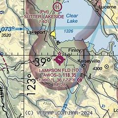
| FAA Identifier: | 1O2 |
| Lat/Long: | 38-59-26.2000N 122-54-02.6000W
38-59.436667N 122-54.043333W
38.9906111,-122.9007222
(estimated) |
| Elevation: | 1380.1 ft. / 420.7 m (surveyed) |
| Variation: | 16E (1990) |
| From city: | 3 miles S of LAKEPORT, CA |
| Time zone: | UTC -7 (UTC -8 during Standard Time) |
| Zip code: | 95453 |
Airport Operations
| Airport use: | Open to the public |
| Activation date: | 10/1941 |
| Control tower: | no |
| ARTCC: | OAKLAND CENTER |
| FSS: | OAKLAND FLIGHT SERVICE STATION |
| NOTAMs facility: | OAK (NOTAM-D service available) |
| Attendance: | UNATNDD |
| Pattern altitude: | 2180.1 ft. MSL |
| Wind indicator: | lighted |
| Segmented circle: | yes |
| Lights: | ACTVT MIRL RWY 10/28 - CTAF. |
| Beacon: | white-green (lighted land airport)
Operates sunset to sunrise. |
Airport Communications
| CTAF/UNICOM: | 122.8 |
| WX AWOS-3: | 118.35 (707-262-0380) |
| WX ASOS at UKI (16 nm NW): | 119.275 (707-462-7343) |
- APCH/DEP CTL SVC PRVDD BY OAKLAND ARTCC (ZOA) ON FREQS 127.8/353.5 (UKIAH RCAG).
Nearby radio navigation aids
| VOR radial/distance | | VOR name | | Freq | | Var |
|---|
| ENIr086/17.8 | | MENDOCINO VORTAC | | 112.30 | | 16E |
Airport Services
| Fuel available: | 100LL |
| Parking: | tiedowns |
| Airframe service: | MAJOR |
| Powerplant service: | MAJOR |
| Bottled oxygen: | NONE |
| Bulk oxygen: | NONE |
Runway Information
Runway 10/28
| Dimensions: | 3600 x 60 ft. / 1097 x 18 m |
| Surface: | asphalt, in good condition |
| Weight bearing capacity: | |
| Runway edge lights: | medium intensity |
| RUNWAY 10 | | RUNWAY 28 |
| Latitude: | 38-59.580570N | | 38-59.292057N |
| Longitude: | 122-54.374978W | | 122-53.711147W |
| Elevation: | 1380.1 ft. | | 1370.8 ft. |
| Traffic pattern: | left | | right |
| Runway heading: | 103 magnetic, 119 true | | 283 magnetic, 299 true |
| Displaced threshold: | no | | 85 ft. |
| Markings: | basic, in good condition | | basic, in good condition |
| Visual slope indicator: | | | 2-light PAPI on left (4.00 degrees glide path) |
| Runway end identifier lights: | no | | no |
| Touchdown point: | yes, no lights | | yes, no lights |
| Obstructions: | 30 ft. trees, 700 ft. from runway, 290 ft. right of centerline, 16:1 slope to clear | | 15 ft. road, 236 ft. from runway, 133 ft. right of centerline, 2:1 slope to clear
APCH RATIO TO DSPLCD THR 21:1. |
Airport Ownership and Management from official FAA records
| Ownership: | Publicly-owned |
| Owner: | LAKE COUNTY
255 N FORBES ST
LAKEPORT, CA 95453
Phone 707-263-2341 |
| Manager: | GLEN MARCH
255 N FORBES ST #309
LAKEPORT, CA 95453
Phone 707-263-2341
PRINCIPAL CIVIL ENGINEER; OFFICE IN LAKEPORT, CA. |
Additional Remarks
| - | FOR CD CTC OAKLAND ARTCC AT 510-745-3380. |
Instrument Procedures
NOTE: All procedures below are presented as PDF files. If you need a reader for these files, you should download the free Adobe Reader.NOT FOR NAVIGATION. Please procure official charts for flight.
FAA instrument procedures published for use from 11 June 2026 at 0901Z to 09 July 2026 at 0900z.
IAPs - Instrument Approach Procedures |
|---|
| RNAV (GPS)-A | |
download (386KB) |
Departure Procedures |
|---|
| LAKEPORT THREE (RNAV) | |
download (136KB) |
| NOTE: Special Take-Off Minimums/Departure Procedures apply | |
download (347KB) |
Other nearby airports with instrument procedures:
O60 - Cloverdale Municipal Airport (14 nm S)
KUKI - Ukiah Municipal Airport (16 nm NW)
KHES - Healdsburg Municipal Airport (20 nm S)
KSTS - Charles M Schulz/Sonoma County Airport (29 nm S)
O28 - Willits Municipal Airport - Ells Field (35 nm NW)
|
|

Road maps at:
MapQuest
Bing
Google
| Aerial photo |
|---|
WARNING: Photo may not be current or correct
 Photo by Nikhil Kalyankar
Photo taken 11-Oct-2009
Photo by Nikhil Kalyankar
Photo taken 11-Oct-2009
Do you have a better or more recent aerial photo of Lampson Field Airport that you would like to share? If so, please send us your photo.
|
| Sectional chart |
|---|
|
| Airport distance calculator |
|---|
|
|
| Sunrise and sunset |
|---|
|
Times for 21-Jun-2026
| | Local
(UTC-7) | | Zulu
(UTC) |
|---|
| Morning civil twilight | | 05:15 | | 12:15 |
| Sunrise | | 05:47 | | 12:47 |
| Sunset | | 20:40 | | 03:40 |
| Evening civil twilight | | 21:12 | | 04:12 |
|
| Current date and time |
|---|
| Zulu (UTC) | 21-Jun-2026 19:15:15 |
|---|
| Local (UTC-7) | 21-Jun-2026 12:15:15 |
|---|
|
| METAR |
|---|
KUKI
16nm NW | 211856Z AUTO VRB04KT 10SM CLR 27/14 A2987 RMK AO2 SLP107 T02720139
|
KSTS
30nm S | 707-573-8393
211853Z VRB05KT 10SM SCT013 18/13 A2992 RMK AO2 SLP126 T01830128
|
|
| TAF |
|---|
KUKI
16nm NW | 211720Z 2118/2218 VRB02KT P6SM SKC FM212300 30009KT P6SM SKC FM220200 VRB03KT P6SM SKC
|
|
| NOTAMs |
|---|
NOTAMs are issued by the DoD/FAA and will open in a separate window not controlled by AirNav.
|
|

