FAA INFORMATION EFFECTIVE 14 MAY 2026
Location
| FAA Identifier: | STS |
| Lat/Long: | 38-30-34.9000N 122-48-46.4000W
38-30.581667N 122-48.773333W
38.5096944,-122.8128889
(estimated) |
| Elevation: | 128.7 ft. / 39.2 m (surveyed) |
| Variation: | 16E (1985) |
| From city: | 6 miles NW of SANTA ROSA, CA |
| Time zone: | UTC -7 (UTC -8 during Standard Time) |
| Zip code: | 95403 |
Airport Operations
| Airport use: | Open to the public |
| Control tower: | yes |
| ARTCC: | OAKLAND CENTER |
| FSS: | OAKLAND FLIGHT SERVICE STATION |
| NOTAMs facility: | STS (NOTAM-D service available) |
| Attendance: | 0600-2200 |
| Pattern altitude: | TPA FOR SMALL ACFT 1,000 FT AGL AND TPA FOR LARGE ACFT 1,500 FT AGL. |
| Wind indicator: | lighted |
| Segmented circle: | yes |
| Lights: | WHEN ATCT CLSD ACTVT REIL RWY 14; MALSR RWY 32; PAPI RWY 02, 20, & 14; HIRL RWY 14/32; MIRL RWY 02/20; TWY LGTS - CTAF. |
| Beacon: | white-green (lighted land airport)
Operates sunset to sunrise. |
| Landing fee: | yes |
| Fire and rescue: | ARFF index B |
Airport Communications
| CTAF: | 118.5 |
| UNICOM: | 122.95 |
| ATIS: | 120.55 |
| WX ASOS: | 120.55 (707-573-8393) |
| SANTA ROSA GROUND: | 121.9 [0700-2000] |
| SANTA ROSA TOWER: | 118.5 363.0 [0700-2000] |
| EMERG: | 121.5 |
| WX AWOS-3P at O69 (18 nm SE): | 132.325 (707-773-1529) |
- APCH/DEP CTL SVC PRVDD BY OAKLAND ARTCC (ZOA) ON FREQ 127.8/353.5 (MOUNT TAMALPAIS RCAG).
Nearby radio navigation aids
| VOR radial/distance | | VOR name | | Freq | | Var |
|---|
| PYEr349/25.9 | | POINT REYES VOR/DME | | 113.70 | | 17E |
| SGDr297/28.7 | | SCAGGS ISLAND VORTAC | | 112.10 | | 17E |
| ENIr131/39.1 | | MENDOCINO VORTAC | | 112.30 | | 16E |
Airport Services
| Fuel available: | 100LL JET-A1
100LL:100LL AVBL 24 HRS WITH CREDIT CARD.
A1:JET A1 AVBL DURG ATTENDANCE HRS. |
| Parking: | tiedowns |
| Airframe service: | MAJOR |
| Powerplant service: | MAJOR |
| Bottled oxygen: | LOW |
| Bulk oxygen: | LOW |
Runway Information
Runway 14/32
| Dimensions: | 6000 x 150 ft. / 1829 x 46 m |
| Surface: | asphalt/grooved, in fair condition |
| Weight bearing capacity: | | Single wheel: | 120.0 | | Double wheel: | 184.0 | | Double tandem: | 300.0 | | Dual double tandem: | 697.0 |
|
| Runway edge lights: | high intensity |
| RUNWAY 14 | | RUNWAY 32 |
| Latitude: | 38-31.051057N | | 38-30.139840N |
| Longitude: | 122-48.828973W | | 122-48.341257W |
| Elevation: | 110.5 ft. | | 120.4 ft. |
| Traffic pattern: | right | | left |
| Runway heading: | 141 magnetic, 157 true | | 321 magnetic, 337 true |
| Declared distances: | TORA:6000 TODA:6000 ASDA:5880 LDA:5880 | | TORA:6000 TODA:6000 ASDA:6000 LDA:6000 |
| Markings: | precision, in good condition | | precision, in good condition |
| Visual slope indicator: | 4-light PAPI on right (3.00 degrees glide path) | | |
| RVR equipment: | rollout | | touchdown |
| Approach lights: | | | MALSR: 1,400 foot medium intensity approach lighting system with runway alignment indicator lights |
| Runway end identifier lights: | yes | | no |
| Touchdown point: | yes, no lights | | yes, no lights |
| Instrument approach: | | | ILS |
| Obstructions: | 17 ft. trees, 800 ft. from runway, 250 ft. left of centerline, 35:1 slope to clear | | 135 ft. trees, 6400 ft. from runway, 45:1 slope to clear |
Runway 2/20
| Dimensions: | 5202 x 100 ft. / 1586 x 30 m |
| Surface: | asphalt/grooved, in fair condition |
| Weight bearing capacity: | | Single wheel: | 109.0 | | Double wheel: | 154.0 | | Double tandem: | 254.0 |
|
| Runway edge lights: | medium intensity |
| RUNWAY 2 | | RUNWAY 20 |
| Latitude: | 38-30.189910N | | 38-30.938160N |
| Longitude: | 122-49.257807W | | 122-48.726047W |
| Elevation: | 128.5 ft. | | 113.3 ft. |
| Traffic pattern: | left | | left |
| Runway heading: | 013 magnetic, 029 true | | 193 magnetic, 209 true |
| Declared distances: | TORA:5202 TODA:5202 ASDA:4802 LDA:4802 | | TORA:5202 TODA:5202 ASDA:5202 LDA:5202 |
| Markings: | nonprecision, in good condition | | basic, in good condition |
| Visual slope indicator: | 2-light PAPI on left (3.00 degrees glide path)
PAPI UNUSBL BYD 5 DEG LEFT OF CNTRLN | | 4-light PAPI on left (3.50 degrees glide path) |
| Runway end identifier lights: | no | | no |
| Touchdown point: | yes, no lights | | yes, no lights |
| Obstructions: | 131 ft. trees, 2900 ft. from runway, 20:1 slope to clear | | 33 ft. trees, 1200 ft. from runway, 200 ft. right of centerline, 30:1 slope to clear |
Airport Ownership and Management from official FAA records
| Ownership: | Publicly-owned |
| Owner: | SONOMA COUNTY
2290 AIRPORT BLVD
SANTA ROSA, CA 95403
Phone 707-565-7243 |
| Manager: | JON G. STOUT
2290 AIRPORT BLVD
SANTA ROSA, CA 95403
Phone 707-565-7243
SAMONAE CARTER, ASST ARPT MGR, PHONE 707- 565-7245. |
Additional Remarks
| A39-02/20 | PCR VALUE: 309/F/C/X/T |
| A39-14/32 | PCR VALUE: 454/F/C/X/T |
| - | FOR NOISE ABATEMENT PROCS PLEASE VISIT THE ARPT WEBSITE AT FLYSTS.COM |
| - | DEER ON AND INVOF ARPT. |
| - | WHEN ATCT CLSD, FOR CD CTC OAKLAND ARTCC AT 510-745-3380. |
| - | TWY Z BTN RWY 14/32 & TWY A LMTD TO S-20, D-40. |
| - | BE ALERT FOR NUMEROUS FLOCKS OF BIRDS ON AND INVOF AIRPORT, INCLUDING SEASONALLY MIGRATORY GEESE. |
| - | (LAHSO_ALD, RWY 02) CTC ATCT FOR AVBLTY. |
Instrument Procedures
NOTE: All procedures below are presented as PDF files. If you need a reader for these files, you should download the free Adobe Reader.NOT FOR NAVIGATION. Please procure official charts for flight.
FAA instrument procedures published for use from 14 May 2026 at 0901Z to 11 June 2026 at 0900Z.
STARs - Standard Terminal Arrivals |
|---|
| REBAS ONE (RNAV) | |
2 pages:
[1] [2] (291KB) |
| VNYRD ONE (RNAV) | |
2 pages:
[1] [2] (290KB) |
IAPs - Instrument Approach Procedures |
|---|
| ILS OR LOC RWY 32 | |
download (468KB) |
| RNAV (GPS) RWY 02 | |
download (312KB) |
| RNAV (GPS) RWY 14 | |
download (432KB) |
| RNAV (GPS) RWY 32 | |
download (333KB) |
| NOTE: Special Alternate Minimums apply | |
download (140KB) |
Departure Procedures |
|---|
| CHARLIE EIGHT | |
download (245KB) |
| CHRRO ONE (RNAV) | |
download (286KB) |
| MMORK ONE (RNAV) | |
download (225KB) |
| RREHD ONE (RNAV) | |
download (241KB) |
| NOTE: Special Take-Off Minimums/Departure Procedures apply | |
download (357KB) |
Other nearby airports with instrument procedures:
KHES - Healdsburg Municipal Airport (9 nm NW)
O69 - Petaluma Municipal Airport (18 nm SE)
O60 - Cloverdale Municipal Airport (18 nm NW)
KDVO - Gnoss Field Airport (25 nm SE)
1O2 - Lampson Field Airport (29 nm N)
|
|

Road maps at:
MapQuest
Bing
Google
| Aerial photo |
|---|
WARNING: Photo may not be current or correct
 Photo courtesy of focalflight.com
Photo taken 16-Mar-2016
looking south.
Photo courtesy of focalflight.com
Photo taken 16-Mar-2016
looking south.
Do you have a better or more recent aerial photo of Charles M Schulz/Sonoma County Airport that you would like to share? If so, please send us your photo.
|
| Sectional chart |
|---|
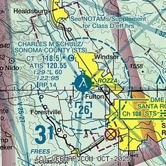
|
CAUTION: Diagram may not be current
 Download PDF
of official airport diagram from the FAA
| Airport distance calculator |
|---|
|
|
| Sunrise and sunset |
|---|
|
Times for 31-May-2026
| | Local
(UTC-7) | | Zulu
(UTC) |
|---|
| Morning civil twilight | | 05:19 | | 12:19 |
| Sunrise | | 05:50 | | 12:50 |
| Sunset | | 20:28 | | 03:28 |
| Evening civil twilight | | 20:59 | | 03:59 |
|
| Current date and time |
|---|
| Zulu (UTC) | 31-May-2026 15:33:24 |
|---|
| Local (UTC-7) | 31-May-2026 08:33:24 |
|---|
|
| METAR |
|---|
| KSTS | 707-573-8393
311453Z 00000KT 10SM CLR 13/10 A3004 RMK AO2 SLP165 T01330100 53004
|
KO69
18nm SE | 311515Z AUTO 7SM CLR 12/09 A3005 RMK A01
|
|
| TAF |
|---|
| KSTS | 311120Z 3112/0112 18003KT P6SM SKC FM312100 18008KT P6SM SKC
|
|
| NOTAMs |
|---|
NOTAMs are issued by the DoD/FAA and will open in a separate window not controlled by AirNav.
|
|


