FAA INFORMATION EFFECTIVE 16 APRIL 2026
Location
| FAA Identifier: | 2M2 |
| Lat/Long: | 35-14-03.4840N 087-15-28.5970W
35-14.058067N 087-15.476617W
35.2343011,-87.2579436
(estimated) |
| Elevation: | 936.5 ft. / 285.4 m (surveyed) |
| Variation: | 01W (1995) |
| From city: | 3 miles NE of LAWRENCEBURG, TN |
| Time zone: | UTC -5 (UTC -6 during Standard Time) |
| Zip code: | 38464 |
Airport Operations
| Airport use: | Open to the public |
| Activation date: | 08/1962 |
| Control tower: | no |
| ARTCC: | MEMPHIS CENTER |
| FSS: | JACKSON FLIGHT SERVICE STATION |
| NOTAMs facility: | MKL (NOTAM-D service available) |
| Attendance: | 0800-1700
AFT HR - 931-231-4075. |
| Wind indicator: | lighted |
| Segmented circle: | yes |
| Lights: | SS-SR |
| Beacon: | white-green (lighted land airport)
Operates sunset to sunrise. |
Airport Communications
| CTAF/UNICOM: | 122.8 |
| WX AWOS-3: | 120.175 (931-766-1585) |
| WX AWOS-3 at GZS (11 nm SE): | 118.275 (931-363-6760) |
| WX AWOS-3 at MRC (20 nm N): | 128.625 (931-379-0844) |
- APCH/DEP SVC PRVDD BY MEMPHIS ARTCC ON FREQS 125.85/379.25 (CENTERVILLE RCAG).
Airport Services
| Fuel available: | 100LL JET-A+ |
| Parking: | hangars and tiedowns |
| Airframe service: | MAJOR
BOTH ON SITE |
| Powerplant service: | MINOR |
| Bottled oxygen: | LOW |
Runway Information
Runway 17/35
| Dimensions: | 5002 x 100 ft. / 1525 x 30 m |
| Surface: | asphalt, in good condition |
| Weight bearing capacity: | | PCN 12 /F/C/X/T | | Single wheel: | 33.5 | | Double wheel: | 50.0 |
|
| Runway edge lights: | medium intensity |
| RUNWAY 17 | | RUNWAY 35 |
| Latitude: | 35-14.458953N | | 35-13.657190N |
| Longitude: | 087-15.593665W | | 087-15.359593W |
| Elevation: | 936.5 ft. | | 927.3 ft. |
| Traffic pattern: | left | | left |
| Runway heading: | 168 magnetic, 167 true | | 348 magnetic, 347 true |
| Markings: | nonprecision, in fair condition | | nonprecision, in fair condition |
| Visual slope indicator: | 4-light PAPI on left (3.00 degrees glide path) | | 4-light PAPI on left (3.00 degrees glide path) |
| Runway end identifier lights: | yes | | yes |
| Touchdown point: | yes, no lights | | yes, no lights |
| Obstructions: | 99 ft. trees, 1732 ft. from runway, 127 ft. left of centerline, 15:1 slope to clear | | 113 ft. trees, 2818 ft. from runway, 167 ft. left of centerline, 24:1 slope to clear |
Airport Ownership and Management from official FAA records
| Ownership: | Publicly-owned |
| Owner: | CITY OF LAWRENCEBURG
233 WEST GAINES
LAWRENCEBURG, TN 38464
Phone 931-762-5133
931-766-4128. |
| Manager: | DOUG SMITH
4110 AIRPORT DR
LAWRENCEBURG, TN 38464
Phone 931-762-5133 |
Additional Remarks
| - | FOR CD CTC MEMPHIS ARTCC AT 901-368-8453/8449. |
Instrument Procedures
NOTE: All procedures below are presented as PDF files. If you need a reader for these files, you should download the free Adobe Reader.NOT FOR NAVIGATION. Please procure official charts for flight.
FAA instrument procedures published for use from 16 April 2026 at 0901Z to 14 May 2026 at 0900Z.
IAPs - Instrument Approach Procedures |
|---|
| RNAV (GPS) RWY 17 | |
download (236KB) |
| RNAV (GPS) RWY 35 | |
download (251KB) |
| NOTE: Special Take-Off Minimums/Departure Procedures apply | |
download (400KB) |
Other nearby airports with instrument procedures:
KGZS - Abernathy Field Airport (11 nm SE)
KMRC - Maury County Regional Airport (20 nm N)
0M3 - Paul Bridges Field Airport (25 nm NW)
KLUG - Ellington Airport (28 nm NE)
KMSL - Northwest Alabama Regional Airport (34 nm SW)
|
|

Road maps at:
MapQuest
Bing
Google
| Aerial photo |
|---|
WARNING: Photo may not be current or correct
 Photo taken 27-Aug-2016
looking north.
Photo taken 27-Aug-2016
looking north.
Do you have a better or more recent aerial photo of Lawrenceburg/Lawrence County Airport (Fleeman Field) that you would like to share? If so, please send us your photo.
|
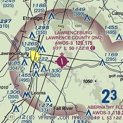
| Sectional chart |
|---|
|
| Airport distance calculator |
|---|
|
|
| Sunrise and sunset |
|---|
|
Times for 03-May-2026
| | Local
(UTC-5) | | Zulu
(UTC) |
|---|
| Morning civil twilight | | 05:29 | | 10:29 |
| Sunrise | | 05:57 | | 10:57 |
| Sunset | | 19:35 | | 00:35 |
| Evening civil twilight | | 20:03 | | 01:03 |
|
| Current date and time |
|---|
| Zulu (UTC) | 04-May-2026 02:13:46 |
|---|
| Local (UTC-5) | 03-May-2026 21:13:46 |
|---|
|
| METAR |
|---|
| K2M2 | 040155Z AUTO 00000KT 10SM CLR 14/05 A3003 RMK A01
|
KGZS
11nm SE | 040155Z AUTO 00000KT 10SM FEW041 FEW048 10/09 A3003 RMK A01
|
KMRC
20nm N | 040150Z AUTO 20003KT 10SM CLR 13/06 A3000 RMK A01
|
|
| NOTAMs |
|---|
NOTAMs are issued by the DoD/FAA and will open in a separate window not controlled by AirNav.
|
|

