FAA INFORMATION EFFECTIVE 16 APRIL 2026
Location
| FAA Identifier: | 3EX |
| Lat/Long: | 39-20-14.2000N 094-11-50.7000W
39-20.236667N 094-11.845000W
39.3372778,-94.1974167
(estimated) |
| Elevation: | 999.6 ft. / 305 m (estimated) |
| Variation: | 01E (2020) |
| From city: | 1 mile E of EXCELSIOR SPRINGS, MO |
| Time zone: | UTC -5 (UTC -6 during Standard Time) |
| Zip code: | 64024 |
Airport Operations
| Airport use: | Open to the public |
| Activation date: | 11/1952 |
| Control tower: | no |
| ARTCC: | KANSAS CITY CENTER |
| FSS: | COLUMBIA FLIGHT SERVICE STATION |
| NOTAMs facility: | COU (NOTAM-D service available) |
| Attendance: | UNATNDD |
| Wind indicator: | lighted |
| Segmented circle: | yes |
| Beacon: | white-green (lighted land airport)
Operates sunset to sunrise. |
Airport Communications
| CTAF/UNICOM: | 122.7 |
| KANSAS CITY APPROACH: | 118.4 |
| KANSAS CITY DEPARTURE: | 118.4 |
| WX AWOS-3P at GPH (5 nm W): | 120.275 (816-407-3399) |
Nearby radio navigation aids
| VOR radial/distance | | VOR name | | Freq | | Var |
|---|
| ANXr341/14.9 | | NAPOLEON VORTAC | | 115.15 | | 07E |
| BQSr217/23.1 | | BRAYMER VOR/DME | | 115.35 | | 03E |
| MCIr078/25.2 | | KANSAS CITY VORTAC | | 113.25 | | 05E |
Airport Services
| Parking: | tiedowns |
| Bottled oxygen: | NONE |
| Bulk oxygen: | NONE |
Runway Information
Runway 3/21
| Dimensions: | 2004 x 50 ft. / 611 x 15 m |
| Surface: | asphalt/aggregate friction seal coat, in fair condition |
| Weight bearing capacity: | |
| Runway edge lights: | low intensity
NSTD LIRL; INCOR SPACING AND COLOR OF LGTS. |
| RUNWAY 3 | | RUNWAY 21 |
| Latitude: | 39-20.078565N | | 39-20.395177N |
| Longitude: | 094-11.905487W | | 094-11.785448W |
| Elevation: | 997.6 ft. | | 992.5 ft. |
| Traffic pattern: | left | | left |
| Runway heading: | 015 magnetic, 016 true | | 195 magnetic, 196 true |
| Markings: | basic, in good condition | | nonprecision, in good condition |
| Touchdown point: | yes, no lights | | yes, no lights |
| Obstructions: | 27 ft. trees, 225 ft. from runway, 145 ft. right of centerline
70 FT TREE 170 FT FM RWY END AND 160 FT LEFT; 40 FT TREE 10 FT FM RWY END AND 230 FT RIGHT. | | 72 ft. trees, 702 ft. from runway, 215 ft. left of centerline, 6:1 slope to clear
+1-10 FT ROAD 0-200 FT FM RWY END 120-160 FT R. |
Airport Ownership and Management from official FAA records
| Ownership: | Publicly-owned |
| Owner: | CITY OF EXCELSIOR SPRINGS
201 E BROADWAY
EXCELSIOR SPRINGS, MO 64024
Phone 816-630-0752 |
| Manager: | JERRY BEEBE, DON MYERS
1400 S. MARIETTA
EXCELSIOR SPRINGS, MO 64024
Phone (816) 678-3667
(816) 682-3764 |
Additional Remarks
| - | WILDLIFE ON & INVOF ARPT. |
| - | FOR CD CTC KANSAS CITY APCH AT 816-329-2710. |
Instrument Procedures
NOTE: All procedures below are presented as PDF files. If you need a reader for these files, you should download the free Adobe Reader.NOT FOR NAVIGATION. Please procure official charts for flight.
FAA instrument procedures published for use from 16 April 2026 at 0901Z to 14 May 2026 at 0900Z.
IAPs - Instrument Approach Procedures |
|---|
| RNAV (GPS)-B | |
download (167KB) |
| NOTE: Special Take-Off Minimums/Departure Procedures apply | |
download (421KB) |
Other nearby airports with instrument procedures:
KGPH - Midwest National Air Center Airport (5 nm W)
3GV - East Kansas City Airport (19 nm S)
KMKC - Kansas City Downtown Airport-Wheeler Field (22 nm SW)
KEZZ - Cameron Memorial Airport (24 nm N)
KMCI - Kansas City International Airport (24 nm W)
|
|

Road maps at:
MapQuest
Bing
Google
| Aerial photo |
|---|
WARNING: Photo may not be current or correct

Do you have a better or more recent aerial photo of Excelsior Springs Memorial Airport that you would like to share? If so, please send us your photo.
|
| Sectional chart |
|---|
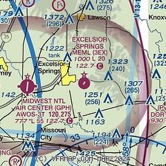
|
| Airport distance calculator |
|---|
|
|
| Sunrise and sunset |
|---|
|
Times for 29-Apr-2026
| | Local
(UTC-5) | | Zulu
(UTC) |
|---|
| Morning civil twilight | | 05:53 | | 10:53 |
| Sunrise | | 06:22 | | 11:22 |
| Sunset | | 20:07 | | 01:07 |
| Evening civil twilight | | 20:36 | | 01:36 |
|
| Current date and time |
|---|
| Zulu (UTC) | 29-Apr-2026 21:34:26 |
|---|
| Local (UTC-5) | 29-Apr-2026 16:34:26 |
|---|
|
| METAR |
|---|
KGPH
5nm W | 292115Z AUTO 35007KT 10SM CLR 15/03 A3008 RMK AO2
|
|
| TAF |
|---|
KMKC
23nm SW | 291734Z 2918/3018 34007KT P6SM SCT035 FM300200 VRB03KT P6SM FEW250 FM301500 26007KT P6SM BKN100
|
KMCI
25nm W | 291734Z 2918/3018 35010KT P6SM SCT030 SCT250 FM300200 VRB04KT P6SM FEW250 FM301500 25007KT P6SM BKN150
|
|
| NOTAMs |
|---|
NOTAMs are issued by the DoD/FAA and will open in a separate window not controlled by AirNav.
|
|

