FAA INFORMATION EFFECTIVE 14 MAY 2026
Location
| FAA Identifier: | 51J |
| Lat/Long: | 33-51-12.8900N 079-46-05.2280W
33-51.214833N 079-46.087133W
33.8535806,-79.7681189
(estimated) |
| Elevation: | 80.2 ft. / 24.4 m (surveyed) |
| Variation: | 06W (1990) |
| From city: | 2 miles SW of LAKE CITY, SC |
| Time zone: | UTC -4 (UTC -5 during Standard Time) |
| Zip code: | 29560 |
Airport Operations
| Airport use: | Open to the public |
| Activation date: | 01/1947 |
| Control tower: | no |
| ARTCC: | JACKSONVILLE CENTER |
| FSS: | ANDERSON FLIGHT SERVICE STATION |
| NOTAMs facility: | AND (NOTAM-D service available) |
| Attendance: | UNATNDD |
| Wind indicator: | lighted |
| Segmented circle: | yes |
| Lights: | ACTVT MIRL RWY 01/19 - CTAF. |
| Beacon: | white-green (lighted land airport) |
Airport Communications
| CTAF: | 122.9 |
| FLORENCE APPROACH: | 135.25 |
| FLORENCE DEPARTURE: | 135.25 |
| WX AWOS-3 at CKI (9 nm SW): | 124.775 (843-382-3000) |
- APCH/DEP SVC PRVDD BY JACKSONVILLE ARTCC ON FREQS 133.45/306.3 (FLORENCE RCAG) WHEN FLORENCE APCH CTL CLSD.
Nearby radio navigation aids
| VOR radial/distance | | VOR name | | Freq | | Var |
|---|
| FLOr197/23.4 | | FLORENCE VORTAC | | 115.20 | | 03W |
| NDB name | | Hdg/Dist | | Freq | | Var | | ID |
|---|
| EVANS | | at field | | 420 | | 06W | | CFY | -.-. ..-. -.-- |
| MANNING | | 060/27.1 | | 381 | | 06W | | MNI | -- -. .. |
| HARTSVILLE | | 159/37.5 | | 341 | | 07W | | HVS | .... ...- ... |
Airport Services
| Parking: | tiedowns |
| Airframe service: | NONE |
| Powerplant service: | NONE |
| Bottled oxygen: | NONE |
| Bulk oxygen: | NONE |
Runway Information
Runway 1/19
| Dimensions: | 3700 x 75 ft. / 1128 x 23 m |
| Surface: | asphalt, in good condition
CRACKS HAVE BEEN FILLED AND RWY PAVEMENT REJUVENATOR APPLIED. |
| Weight bearing capacity: | |
| Runway edge lights: | medium intensity |
| RUNWAY 1 | | RUNWAY 19 |
| Latitude: | 33-50.911683N | | 33-51.517983N |
| Longitude: | 079-46.126700W | | 079-46.047550W |
| Elevation: | 80.1 ft. | | 80.1 ft. |
| Traffic pattern: | left | | left |
| Runway heading: | 012 magnetic, 006 true | | 192 magnetic, 186 true |
| Markings: | nonprecision, in good condition | | nonprecision, in good condition |
| Visual slope indicator: | 2-box VASI on left (3.00 degrees glide path) | | 2-box VASI on left (3.00 degrees glide path) |
| Touchdown point: | yes, no lights | | yes, no lights |
| Obstructions: | 71 ft. tree, 1096 ft. from runway, 232 ft. right of centerline, 12:1 slope to clear
CLOSE-IN TREELINE 169 FT L OF CNTRLN ON RWY 01 APCH. | | 74 ft. tree, 1160 ft. from runway, 180 ft. right of centerline, 12:1 slope to clear |
Airport Ownership and Management from official FAA records
| Ownership: | Publicly-owned |
| Owner: | TOWN OF LAKE CITY
PO BOX 1329
LAKE CITY, SC 29560
Phone (843) 374-5421
TOWN ADMIR IS STEPHANIE SNOWDEN. |
| Manager: | DUSAN FRIDL
PO BOX 1329
LAKE CITY, SC 29560
Phone 843-687-6490 |
Additional Remarks
| - | RWY 19 TWO RDO TOWERS 1 1/2-1 3/4 MI. FROM END RIGHT OF CNTRLN; ALSO LGTD WATER TANK 3/4 MI FROM END. |
| - | FOR CD CTC FLORENCE APCH AT 843-665-0632, WHEN APCH CLSD CTC JACKSONVILLE ARTCC AT 904-845-1592. |
Instrument Procedures
NOTE: All procedures below are presented as PDF files. If you need a reader for these files, you should download the free Adobe Reader.NOT FOR NAVIGATION. Please procure official charts for flight.
FAA instrument procedures published for use from 14 May 2026 at 0901Z to 11 June 2026 at 0900Z.
IAPs - Instrument Approach Procedures |
|---|
| RNAV (GPS) RWY 01 **CHANGED** | |
download (231KB) |
| RNAV (GPS) RWY 19 **CHANGED** | |
download (227KB) |
| NOTE: Special Take-Off Minimums/Departure Procedures apply | |
download (356KB) |
Other nearby airports with instrument procedures:
KCKI - Williamsburg Regional Airport (9 nm SW)
KFLO - Florence Regional Airport (20 nm N)
KPHH - Robert F Swinnie Airport (27 nm SE)
KMNI - Santee Cooper Regional Airport (27 nm SW)
KMAO - Marion County Airport (29 nm NE)
|
|

Road maps at:
MapQuest
Bing
Google
| Aerial photo |
|---|
WARNING: Photo may not be current or correct
 Photo by King Martin
Photo taken 10-Dec-2020
looking north.
Photo by King Martin
Photo taken 10-Dec-2020
looking north.
Do you have a better or more recent aerial photo of Lake City Municipal Airport-CJ Evans Field that you would like to share? If so, please send us your photo.
|
| Sectional chart |
|---|
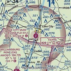
|
| Airport distance calculator |
|---|
|
|
| Sunrise and sunset |
|---|
|
Times for 26-May-2026
| | Local
(UTC-4) | | Zulu
(UTC) |
|---|
| Morning civil twilight | | 05:44 | | 09:44 |
| Sunrise | | 06:12 | | 10:12 |
| Sunset | | 20:20 | | 00:20 |
| Evening civil twilight | | 20:48 | | 00:48 |
|
| Current date and time |
|---|
| Zulu (UTC) | 27-May-2026 01:18:51 |
|---|
| Local (UTC-4) | 26-May-2026 21:18:51 |
|---|
|
| METAR |
|---|
KCKI
9nm SW | 270055Z AUTO 00000KT 10SM SCT037 25/21 A3008 RMK AO2 LTG DSNT W
|
KFLO
20nm N | 270053Z 12003KT 10SM FEW038 24/23 A3008 RMK AO2 LTG DSNT W SLP182 T02390233
|
|
| TAF |
|---|
KFLO
20nm N | 262143Z 2622/2718 VRB05KT P6SM VCSH SCT025 BKN080 TEMPO 2622/2624 4SM SHRA BKN025 FM270000 20005KT P6SM SCT030 BKN090 FM271000 21004KT P6SM BKN015 FM271600 24009KT P6SM VCSH BKN040 PROB30 2716/2718 2SM TSRA BKN025CB
|
|
| NOTAMs |
|---|
NOTAMs are issued by the DoD/FAA and will open in a separate window not controlled by AirNav.
|
|

