FAA INFORMATION EFFECTIVE 19 MARCH 2026
Location
| FAA Identifier: | 99CL |
| Lat/Long: | 34-37-31.5500N 117-35-53.9000W
34-37.525833N 117-35.898333W
34.6254306,-117.5983056
(estimated) |
| Elevation: | 2856 ft. / 871 m (estimated) |
| Variation: | 14E (1985) |
| From city: | 3 miles W of EL MIRAGE, CA |
| Time zone: | UTC -7 (UTC -8 during Standard Time) |
| Zip code: | 92301 |
Airport Operations
| Airport use: | Private use. Permission required prior to landing |
| Activation date: | 07/1944 |
| Control tower: | no |
| ARTCC: | LOS ANGELES CENTER |
| FSS: | RIVERSIDE FLIGHT SERVICE STATION |
| Attendance: | CONTINUOUS |
| Pattern altitude: | 4356 ft. MSL |
| Wind indicator: | yes |
| Segmented circle: | no |
Airport Communications
| WX AWOS-3 at VCV (11 nm E): | 135.475 (760-246-3635) |
Nearby radio navigation aids
| VOR radial/distance | | VOR name | | Freq | | Var |
|---|
| VCVr266/10.5 | | VICTORVILLE VOR/DME | | 109.05 | | 14E |
| EDWr151/22.4 | | EDWARDS VORTAC | | 116.40 | | 12E |
| PMDr076/23.0 | | PALMDALE VORTAC | | 115.55 | | 15E |
| POMr001/34.1 | | POMONA VORTAC | | 110.40 | | 15E |
Airport Services
Runway Information
Runway 8/26
| Dimensions: | 6386 x 150 ft. / 1946 x 46 m |
| Surface: | asphalt, in good condition |
| RUNWAY 8 | | RUNWAY 26 |
| Latitude: | 34-37.518333N | | 34-37.533333N |
| Longitude: | 117-36.535000W | | 117-35.261667W |
| Elevation: | 2855.0 ft. | | 2849.0 ft. |
| Traffic pattern: | left | | right |
| Displaced threshold: | 578 ft. | | 605 ft. |
| Markings: | nonprecision, in good condition | | nonprecision, in good condition |
| Obstructions: | 10 ft. fence, 130 ft. from runway | | 10 ft. fence, 60 ft. from runway |
Airport Ownership and Management from official FAA records
| Ownership: | Privately-owned |
| Owner: | SORRENTO WEST PROPERTIES, INC.
3377 N TORREY PINES COURT, SUITE 100
LA JOLLA, CA 92037
Phone 760-388-8170 |
| Manager: | V.P. FLIGHT OPERATIONS
73 EL MIRAGE AIRPORT RD, ATTN: BUSINESS MANAGER
ADELANTO, CA 92301
Phone 760-388-8170
V.P. FLIGHT OPERATIONS, 73 EL MIRAGE AIRPORT RD, ATTN: BUSINESS MANAGER, ADELANTO, CA 92301 |
Additional Remarks
| - | FOR CD CTC JOSHUA APCH AT 661-277-3843. |
| - | CTN CONS LRG 12500 LB PLUS MTOW REMOTELY PILOTED ACFT SYSTEMS (RPAS)/UNMANNED ACFT SYSTEMS (UAS) OPS IN CLASS G AND E ASP SFC TO 13000 FT MSL IN THE VCNTY OF 99CL EL MIRAGE FIELD AND/OR TRANSIT TO/FROM R-2515. CHECK NOTAMS, UAS OPERG AREAS (UOA) AND CTC JOSHUA APCH FOR STATUS OF RPAS/UAS TFC. |
| - | BIRD AND ANIMAL STRIKE HAZ IN AREA, VCNTY ALL RWYS, TWYS, AND RAMPS. |
| - | ACFT TRANSITING 99CL RMN WELL CLEAR AVOIDING THE FLOW OF FIXED-WING TFC PAT. RPAS/UAS PAT ALT IS 1500 FT AGL. |
Instrument Procedures
There are no published instrument procedures at 99CL.
Some nearby airports with instrument procedures:
KVCV - Southern California Logistics Airport (11 nm E)
KAPV - Apple Valley Airport (21 nm E)
KEDW - Edwards Air Force Base (22 nm NW)
KPMD - Palmdale USAF Plant 42 Airport (24 nm W)
KCCB - Cable Airport (31 nm S)
|
|

Road maps at:
MapQuest
Bing
Google
| Aerial photo |
|---|
WARNING: Photo may not be current or correct
 Photo by Daniel Koneck, 8-1-03
Do you have a better or more recent aerial photo of El Mirage Field Adelanto Airport that you would like to share? If so, please send us your photo.
|
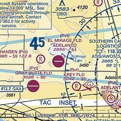
| Sectional chart |
|---|
|
| Airport distance calculator |
|---|
|
|
| Sunrise and sunset |
|---|
|
Times for 04-Apr-2026
| | Local
(UTC-7) | | Zulu
(UTC) |
|---|
| Morning civil twilight | | 06:09 | | 13:09 |
| Sunrise | | 06:34 | | 13:34 |
| Sunset | | 19:13 | | 02:13 |
| Evening civil twilight | | 19:38 | | 02:38 |
|
| Current date and time |
|---|
| Zulu (UTC) | 04-Apr-2026 15:12:16 |
|---|
| Local (UTC-7) | 04-Apr-2026 08:12:16 |
|---|
|
| METAR |
|---|
KVCV
11nm E | 041455Z AUTO 00000KT 10SM CLR 09/M06 A3023 RMK AO2
|
|
| TAF |
|---|
KEDW
20nm NW | 032355Z 0400/0503 06012KT 9999 BKN280 510006 QNH3011INS BECMG 0323/0324 06012KT 9999 BKN280 510006 QNH3009INS BECMG 0404/0405 VRB06KT 9999 BKN280 510006 QNH3014INS BECMG 0411/0412 VRB06KT 9999 SCT280 510006 QNH3015INS BECMG 0415/0416 05010G18KT 9999 SCT250 520009 520903 QNH3016INS BECMG 0418/0419 05015G23KT 9999 SCT200 BKN250 520009 520903 QNH3007INS BECMG 0422/0423 05010G18KT 9999 SCT200 BKN250 510009 510903 QNH3005INS BECMG 0423/0424 07008KT 9999 SCT200 BKN250 QNH3004INS BECMG 0501/0502 VRB05K
|
KPMD
24nm W | 041142Z 0412/0512 VRB05KT P6SM FEW250 FM041800 06012G20KT P6SM SCT250 FM050100 06008KT P6SM SCT250 FM050400 VRB05KT P6SM SKC
|
|
| NOTAMs |
|---|
NOTAMs are issued by the DoD/FAA and will open in a separate window not controlled by AirNav.
|
|


