FAA INFORMATION EFFECTIVE 16 APRIL 2026
Location
| FAA Identifier: | ATS |
| Lat/Long: | 32-51-07.0000N 104-28-03.3000W
32-51.116667N 104-28.055000W
32.8519444,-104.4675833
(estimated) |
| Elevation: | 3544.5 ft. / 1080.4 m (surveyed) |
| Variation: | 09E (2000) |
| From city: | 3 miles W of ARTESIA, NM |
| Time zone: | UTC -6 (UTC -7 during Standard Time) |
| Zip code: | 88210 |
Airport Operations
| Airport use: | Open to the public |
| Activation date: | 11/1944 |
| Control tower: | no |
| ARTCC: | ALBUQUERQUE CENTER |
| FSS: | ALBUQUERQUE FLIGHT SERVICE STATION |
| NOTAMs facility: | ATS (NOTAM-D service available) |
| Attendance: | 0700-1700
CLSD HOL. |
| Wind indicator: | lighted |
| Segmented circle: | yes |
| Lights: | ACTVT PAPI RWY 04, 13, 22 & 31; MIRL RWY 04/22 & 13/31 - CTAF. |
| Beacon: | white-green (lighted land airport)
Operates sunset to sunrise. |
Airport Communications
| CTAF/UNICOM: | 123.075 |
| WX AWOS-3: | 126.725 (575-748-0270) |
| ROSWELL APPROACH: | 119.6 |
| ROSWELL DEPARTURE: | 119.6 |
- APCH/DEP SVC PRVDD BY ALBUQUERQUE ARTCC ON FREQS 132.65/257.6 (ROSWELL RCAG) WHEN ROSWELL APCH CTL CLSD.
Nearby radio navigation aids
| VOR radial/distance | | VOR name | | Freq | | Var |
|---|
| CMEr153/30.1 | | CHISUM VORTAC | | 116.10 | | 12E |
| CNMr329/37.8 | | CARLSBAD VORTAC | | 116.30 | | 12E |
Airport Services
| Fuel available: | 100LL JET-A1 |
| Parking: | hangars and tiedowns |
Runway Information
Runway 4/22
| Dimensions: | 6800 x 150 ft. / 2073 x 46 m |
| Surface: | asphalt/porous friction courses, in good condition |
| Weight bearing capacity: | | PCN 17 /F/C/Y/T | | Single wheel: | 40.0 | | Double wheel: | 57.0 |
|
| Runway edge lights: | medium intensity |
| RUNWAY 4 | | RUNWAY 22 |
| Latitude: | 32-50.704247N | | 32-51.496398N |
| Longitude: | 104-28.574517W | | 104-27.634678W |
| Elevation: | 3544.5 ft. | | 3519.5 ft. |
| Traffic pattern: | left | | left |
| Runway heading: | 036 magnetic, 045 true | | 216 magnetic, 225 true |
| Displaced threshold: | 499 ft. | | no |
| Markings: | basic, in good condition | | nonprecision, in good condition |
| Visual slope indicator: | 4-light PAPI on left (3.00 degrees glide path) | | 4-light PAPI on left (3.00 degrees glide path) |
| Touchdown point: | yes, no lights | | yes, no lights |
Runway 13/31
| Dimensions: | 6132 x 100 ft. / 1869 x 30 m |
| Surface: | asphalt/porous friction courses, in good condition |
| Weight bearing capacity: | | PCN 17 /F/C/Y/T | | Single wheel: | 40.0 | | Double wheel: | 57.0 |
|
| Runway edge lights: | medium intensity |
| RUNWAY 13 | | RUNWAY 31 |
| Latitude: | 32-51.492053N | | 32-50.776800N |
| Longitude: | 104-28.422237W | | 104-27.575783W |
| Elevation: | 3533.5 ft. | | 3506.3 ft. |
| Traffic pattern: | left | | left |
| Runway heading: | 126 magnetic, 135 true | | 306 magnetic, 315 true |
| Markings: | nonprecision, in good condition | | nonprecision, in good condition |
| Visual slope indicator: | 4-light PAPI on left (3.00 degrees glide path) | | 4-light PAPI on left (3.00 degrees glide path) |
| Touchdown point: | yes, no lights | | yes, no lights |
Airport Ownership and Management from official FAA records
| Ownership: | Publicly-owned |
| Owner: | CITY OF ARTESIA
702 AIRPORT RD
ARTESIA, NM 88210
Phone 575-746-2122 |
| Manager: | LANCE GOODRICH
PO BOX 1310
ARTESIA, NM 88211
Phone 575-748-3206 |
Additional Remarks
| A57-04 | CLNC SLOPE 50:1 TO DTHR. |
| - | FOR CD CTC ALBUQUERQUE ARTCC AT 505-856-4861. |
| - | AFT HR FUEL & EMERG REPAIR - AMGR. |
Instrument Procedures
NOTE: All procedures below are presented as PDF files. If you need a reader for these files, you should download the free Adobe Reader.NOT FOR NAVIGATION. Please procure official charts for flight.
FAA instrument procedures published for use from 16 April 2026 at 0901Z to 14 May 2026 at 0900Z.
IAPs - Instrument Approach Procedures |
|---|
| RNAV (GPS) RWY 13 | |
download (241KB) |
| RNAV (GPS) RWY 22 | |
download (230KB) |
| RNAV (GPS) RWY 31 | |
download (205KB) |
| NOTE: Special Alternate Minimums apply | |
download (144KB) |
| NOTE: Special Take-Off Minimums/Departure Procedures apply | |
download (188KB) |
Other nearby airports with instrument procedures:
KROW - Roswell Air Center Airport (27 nm N)
KCNM - Cavern City Air Terminal (33 nm S)
E06 - Lea County/Zip Franklin Memorial Airport (54 nm E)
KHOB - Lea County Regional Airport (64 nm E)
KSRR - Sierra Blanca Regional Airport (65 nm NW)
|
|

Road maps at:
MapQuest
Bing
Google
| Aerial photo |
|---|
WARNING: Photo may not be current or correct
 Photo by Joshua Griffin
Photo taken 19-Oct-2009
facing south.
Photo by Joshua Griffin
Photo taken 19-Oct-2009
facing south.
Do you have a better or more recent aerial photo of Artesia Municipal Airport that you would like to share? If so, please send us your photo.
|
| Sectional chart |
|---|
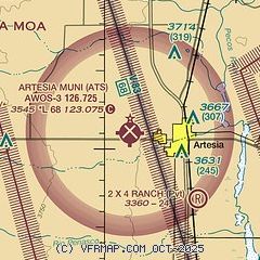
|
| Airport distance calculator |
|---|
|
|
| Sunrise and sunset |
|---|
|
Times for 25-Apr-2026
| | Local
(UTC-6) | | Zulu
(UTC) |
|---|
| Morning civil twilight | | 05:52 | | 11:52 |
| Sunrise | | 06:18 | | 12:18 |
| Sunset | | 19:34 | | 01:34 |
| Evening civil twilight | | 20:00 | | 02:00 |
|
| Current date and time |
|---|
| Zulu (UTC) | 25-Apr-2026 08:27:51 |
|---|
| Local (UTC-6) | 25-Apr-2026 02:27:51 |
|---|
|
| METAR |
|---|
| KATS | 250815Z AUTO 27012KT 10SM CLR 20/M07 A2977 RMK AO2
|
|
| TAF |
|---|
KROW
27nm N | 250540Z 2506/2606 24011KT P6SM SCT200 FM251100 VRB05KT P6SM SCT200 FM252000 24014G24KT P6SM BKN160 FM260200 24012KT P6SM BKN160
|
KCNM
33nm S | 250520Z 2506/2606 22010KT P6SM SCT250 FM251700 26016G25KT P6SM SCT250 FM260300 24010KT P6SM BKN250
|
|
| NOTAMs |
|---|
NOTAMs are issued by the DoD/FAA and will open in a separate window not controlled by AirNav.
|
|


