FAA INFORMATION EFFECTIVE 22 JANUARY 2026
Location
| FAA Identifier: | AXX |
| Lat/Long: | 36-25-19.2010N 105-17-23.6580W
36-25.320017N 105-17.394300W
36.4220003,-105.2899050
(estimated) |
| Elevation: | 8379.5 ft. / 2554.1 m (surveyed) |
| Variation: | 10E (2000) |
| From city: | 1 mile N of ANGEL FIRE, NM |
| Time zone: | UTC -7 (UTC -6 during Daylight Saving Time) |
| Zip code: | 87710 |
Airport Operations
| Airport use: | Open to the public |
| Activation date: | 09/1966 |
| Control tower: | no |
| ARTCC: | ALBUQUERQUE CENTER |
| FSS: | ALBUQUERQUE FLIGHT SERVICE STATION |
| NOTAMs facility: | ABQ (NOTAM-D service available) |
| Attendance: | 0800-1630 |
| Wind indicator: | lighted |
| Segmented circle: | yes |
| Lights: | ACTVT MIRL RY 17/35 & PSIL - CTAF. |
| Beacon: | white-green (lighted land airport)
ACTVT ROTG BCN - CTAF. |
Airport Communications
| CTAF/UNICOM: | 122.8 |
| WX AWOS-3: | 118.025 (575-377-0526) |
| WX AWOS-3PT at SKX (19 nm W): | 132.975 (575-758-5663) |
- APCH/DEP SVC PRVDD BY ALBUQUERQUE ARTCC ON FREQS 132.8/346.35 (RATON RCAG).
Nearby radio navigation aids
| VOR radial/distance | | VOR name | | Freq | | Var |
|---|
| CIMr245/20.6 | | CIMARRON VORTAC | | 116.40 | | 13E |
| TASr098/31.8 | | TAOS VORTAC | | 115.80 | | 13E |
Airport Services
| Fuel available: | 100LL JET-A+
100LL:24 HR. SELF SERVE 100LL, JETA+ WITH MAJOR CREDIT CARD |
| Parking: | hangars and tiedowns |
Runway Information
Runway 17/35
| Dimensions: | 8900 x 100 ft. / 2713 x 30 m |
| Surface: | asphalt, in good condition |
| Weight bearing capacity: | | PCN 37 /F/C/X/T | | Single wheel: | 30.0 | | Double wheel: | 45.0 |
|
| Runway edge lights: | medium intensity |
| RUNWAY 17 | | RUNWAY 35 |
| Latitude: | 36-26.052750N | | 36-24.587267N |
| Longitude: | 105-17.366567W | | 105-17.422050W |
| Elevation: | 8322.3 ft. | | 8379.5 ft. |
| Traffic pattern: | left | | left |
| Runway heading: | 172 magnetic, 182 true | | 352 magnetic, 002 true |
| Markings: | nonprecision, in fair condition | | basic, in fair condition |
| Visual slope indicator: | pulsating/steady burning VASI on left | | |
| Runway end identifier lights: | yes | | yes |
| Touchdown point: | yes, no lights | | yes, no lights |
| Obstructions: | 118 ft. gnd, 2576 ft. from runway, 360 ft. right of centerline, 20:1 slope to clear | | 8 ft. road, 360 ft. from runway, 20:1 slope to clear |
Airport Ownership and Management from official FAA records
| Ownership: | Publicly-owned |
| Owner: | COLFAX COUNTY
PO BOX 1498
RATON, NM 88740
Phone 575-445-9661 |
| Manager: | JEFFERY GILMER
PO BOX 610
ANGEL FIRE, NM 87710
Phone 575-447-1194 |
Additional Remarks
| - | ARPT LCTD IN MOUNTAIN VALLEY; RISING TERRAIN IN ALL DIRECTIONS. STRONG GUSTY CROSSWINDS POSSIBLE. HIGH DENSITY ALTITUDE PROBABLE. |
| - | FOR CD CTC ALBUQUERQUE ARTCC AT 505-856-4861. |
| - | 6-8 INCH DROP OFF AT THLD OF RWY 17. |
| - | AVOID OVERFLIGHT OF TAOS PUEBLO WORLD HERITGE SITE WEST OF ARPT. |
| - | COLD TEMPERATURE AIRPORT. ALTITUDE CORRECTION REQUIRED AT OR BELOW -29C. |
Instrument Procedures
NOTE: All procedures below are presented as PDF files. If you need a reader for these files, you should download the free Adobe Reader.NOT FOR NAVIGATION. Please procure official charts for flight.
FAA instrument procedures published for use from 22 January 2026 at 0901Z to 19 February 2026 at 0900z.
IAPs - Instrument Approach Procedures |
|---|
| RNAV (GPS) RWY 17 | |
download (518KB) |
|
|---|
| ANEKE TWO (OBSTACLE) (RNAV) | |
download (135KB) |
| NOTE: Special Take-Off Minimums/Departure Procedures apply | |
download (105KB) |
Other nearby airports with instrument procedures:
KSKX - Taos Regional Airport (19 nm W)
KRTN - Raton Municipal Airport/Crews Field (43 nm NE)
KLVS - Las Vegas Municipal Airport (47 nm S)
KLAM - Los Alamos Airport (58 nm SW)
KSAF - Santa Fe Regional Airport (62 nm SW)
|
|

Road maps at:
MapQuest
Bing
Google
| Aerial photo |
|---|
WARNING: Photo may not be current or correct
 Photo by Dave Newcomer
Photo taken 23-Sep-2010
looking southwest from 11,000' altitude.
Photo by Dave Newcomer
Photo taken 23-Sep-2010
looking southwest from 11,000' altitude.
Do you have a better or more recent aerial photo of Angel Fire Airport that you would like to share? If so, please send us your photo.
|
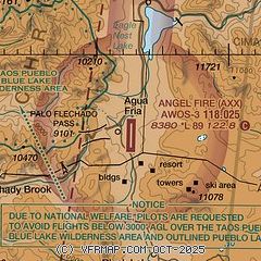
| Sectional chart |
|---|
|
| Airport distance calculator |
|---|
|
|
| Sunrise and sunset |
|---|
|
Times for 07-Feb-2026
| | Local
(UTC-7) | | Zulu
(UTC) |
|---|
| Morning civil twilight | | 06:32 | | 13:32 |
| Sunrise | | 06:58 | | 13:58 |
| Sunset | | 17:32 | | 00:32 |
| Evening civil twilight | | 17:59 | | 00:59 |
|
| Current date and time |
|---|
| Zulu (UTC) | 07-Feb-2026 16:45:56 |
|---|
| Local (UTC-7) | 07-Feb-2026 09:45:56 |
|---|
|
| METAR |
|---|
| KAXX | 071635Z AUTO 25008KT 10SM CLR 07/M07 A3036 RMK AO2 T00721068
|
|
| NOTAMs |
|---|
NOTAMs are issued by the DoD/FAA and will open in a separate window not controlled by AirNav.
|
|


