FAA INFORMATION EFFECTIVE 16 APRIL 2026
Location
| FAA Identifier: | RTN |
| Lat/Long: | 36-44-32.7810N 104-30-06.2150W
36-44.546350N 104-30.103583W
36.7424392,-104.5017264
(estimated) |
| Elevation: | 6352.4 ft. / 1936.2 m (surveyed) |
| Variation: | 10E (2000) |
| From city: | 10 miles SW of RATON, NM |
| Time zone: | UTC -6 (UTC -7 during Standard Time) |
| Zip code: | 87740 |
Airport Operations
| Airport use: | Open to the public |
| Control tower: | no |
| ARTCC: | ALBUQUERQUE CENTER |
| FSS: | ALBUQUERQUE FLIGHT SERVICE STATION |
| NOTAMs facility: | RTN (NOTAM-D service available) |
| Attendance: | 0700-1700 |
| Wind indicator: | lighted |
| Segmented circle: | yes |
| Lights: | ACTVT PAPI RWY 02; MIRL RWY 02/20 & 07/25 - CTAF. DUSK-2300 PAPI RWY 02; MIRL RWY 02/20 & 07/25 PRESET LOW INTST; INCR INTST - CTAF. |
| Beacon: | white-green (lighted land airport)
Operates sunset to sunrise. |
Airport Communications
| CTAF/UNICOM: | 122.8 |
| WX ASOS: | 118.375 (575-303-2003) |
- APCH/DEP SVC PRVDD BY ALBUQUERQUE ARTCC ON FREQS 132.8/346.35 (RATON RCAG).
Nearby radio navigation aids
| VOR radial/distance | | VOR name | | Freq | | Var |
|---|
| CIMr037/23.3 | | CIMARRON VORTAC | | 116.40 | | 13E |
Airport Services
| Fuel available: | 100LL JET-A1+ |
| Parking: | hangars and tiedowns |
| Airframe service: | MINOR |
| Powerplant service: | MINOR |
| Bottled oxygen: | HIGH/LOW |
Runway Information
Runway 2/20
| Dimensions: | 7615 x 75 ft. / 2321 x 23 m |
| Surface: | asphalt, in excellent condition |
| Weight bearing capacity: | | PCN 25 /F/D/X/T | | Single wheel: | 18.0 |
|
| Runway edge lights: | medium intensity |
| RUNWAY 2 | | RUNWAY 20 |
| Latitude: | 36-44.051310N | | 36-45.089363N |
| Longitude: | 104-30.674432W | | 104-29.798098W |
| Elevation: | 6332.3 ft. | | 6348.6 ft. |
| Traffic pattern: | left | | left |
| Runway heading: | 024 magnetic, 034 true | | 204 magnetic, 214 true |
| Markings: | nonprecision, in good condition | | nonprecision, in good condition |
| Visual slope indicator: | 2-light PAPI on left (3.00 degrees glide path) | | |
| Touchdown point: | yes, no lights | | yes, no lights |
Runway 7/25
| Dimensions: | 4425 x 75 ft. / 1349 x 23 m |
| Surface: | asphalt, in good condition |
| Weight bearing capacity: | | PCN 6 /F/D/X/T | | Single wheel: | 12.0 |
|
| Runway edge lights: | medium intensity |
| RUNWAY 7 | | RUNWAY 25 |
| Latitude: | 36-44.426827N | | 36-44.583262N |
| Longitude: | 104-30.317657W | | 104-29.432657W |
| Elevation: | 6342.0 ft. | | 6309.7 ft. |
| Traffic pattern: | left | | left |
| Runway heading: | 068 magnetic, 078 true | | 248 magnetic, 258 true |
| Markings: | basic, in good condition | | nonprecision, in good condition |
| Touchdown point: | yes, no lights | | yes, no lights |
Airport Ownership and Management from official FAA records
| Ownership: | Publicly-owned |
| Owner: | CITY OF RATON
BOX 19
RATON, NM 87740
Phone 575-445-9551 |
| Manager: | DUSTY LONGWILL
HCR 62 BOX 19
RATON, NM 87740
Phone 575-445-3076
575-707-2225. |
Additional Remarks
| - | RWY 02/20 UNLGTD STWY; 240 FT S END; 150 FT NORTH END. |
| - | COMPASS ROSE ON RAMP. |
| - | FOR CD CTC ALBUQUERQUE ARTCC AT 505-856-4861. |
Instrument Procedures
NOTE: All procedures below are presented as PDF files. If you need a reader for these files, you should download the free Adobe Reader.NOT FOR NAVIGATION. Please procure official charts for flight.
FAA instrument procedures published for use from 16 April 2026 at 0901Z to 14 May 2026 at 0900Z.
IAPs - Instrument Approach Procedures |
|---|
| RNAV (GPS) RWY 02 | |
download (172KB) |
| RNAV (GPS) RWY 25 | |
download (208KB) |
| NOTE: Special Alternate Minimums apply | |
download (140KB) |
| NOTE: Special Take-Off Minimums/Departure Procedures apply | |
download (289KB) |
Other nearby airports with instrument procedures:
KTAD - Perry Stokes Airport (32 nm N)
KAXX - Angel Fire Airport (43 nm SW)
4V1 - Spanish Peaks Airfield (59 nm N)
KSKX - Taos Regional Airport (59 nm W)
KCAO - Clayton Municipal Airpark (67 nm E)
|
|

Road maps at:
MapQuest
Bing
Google
| Aerial photo |
|---|
WARNING: Photo may not be current or correct

Do you have a better or more recent aerial photo of Raton Municipal Airport/Crews Field that you would like to share? If so, please send us your photo.
|
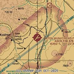
| Sectional chart |
|---|
|
CAUTION: Diagram may not be current

| Airport distance calculator |
|---|
|
|
| Sunrise and sunset |
|---|
|
Times for 09-May-2026
| | Local
(UTC-6) | | Zulu
(UTC) |
|---|
| Morning civil twilight | | 05:28 | | 11:28 |
| Sunrise | | 05:57 | | 11:57 |
| Sunset | | 19:52 | | 01:52 |
| Evening civil twilight | | 20:21 | | 02:21 |
|
| Current date and time |
|---|
| Zulu (UTC) | 09-May-2026 06:34:13 |
|---|
| Local (UTC-6) | 09-May-2026 00:34:13 |
|---|
|
| METAR |
|---|
KRTN
7nm W | 090553Z AUTO 00000KT 10SM CLR 11/00 A3006 RMK AO2 SLP105 T01110000 10233 20094 50012
|
|
| NOTAMs |
|---|
NOTAMs are issued by the DoD/FAA and will open in a separate window not controlled by AirNav.
|
|


