FAA INFORMATION EFFECTIVE 19 MARCH 2026
Location
| FAA Identifier: | AZC |
| Lat/Long: | 36-57-35.8000N 113-00-50.0000W
36-57.596667N 113-00.833333W
36.9599444,-113.0138889
(estimated) |
| Elevation: | 4873.8 ft. / 1485.5 m (surveyed) |
| Variation: | 13E (1995) |
| From city: | 3 miles SW of COLORADO CITY, AZ |
| Time zone: | UTC -7 (year round; does not observe DST) |
| Zip code: | 86021 |
Airport Operations
| Airport use: | Open to the public |
| Control tower: | no |
| ARTCC: | LOS ANGELES CENTER |
| FSS: | PRESCOTT FLIGHT SERVICE STATION |
| NOTAMs facility: | PRC (NOTAM-D service available) |
| Attendance: | MON-SAT 0800-1800 |
| Pattern altitude: | 5721.8 ft. MSL |
| Wind indicator: | lighted |
| Segmented circle: | yes |
| Lights: | ACTVT REIL RWY 11; PAPI RWY 02 & 11; MIRL RWY 02/20 & 11/29 - CTAF. |
| Beacon: | white-green (lighted land airport)
Operates sunset to sunrise. |
Airport Communications
| CTAF/UNICOM: | 122.7 |
| WX AWOS-3PT: | 118.375 (928-875-8045) |
- APCH/DEP CTL SVC PRVDD BY LOS ANGELES ARTCC (ZLA) ON FREQS 124.2/343.6 (CEDAR CITY RCAG).
Nearby radio navigation aids
| VOR radial/distance | | VOR name | | Freq | | Var |
|---|
| UTIr086/24.4 | | ST GEORGE VOR/DME | | 108.60 | | 12E |
Airport Services
| Fuel available: | 100LL JET-A+ |
| Parking: | hangars and tiedowns |
| Airframe service: | MAJOR
CALL - AMGR. |
| Powerplant service: | MAJOR
CALL - AMGR. |
| Bottled oxygen: | HIGH |
| Bulk oxygen: | HIGH/LOW |
Runway Information
Runway 11/29
| Dimensions: | 6300 x 75 ft. / 1920 x 23 m |
| Surface: | asphalt, in good condition |
| Weight bearing capacity: | |
| Runway edge lights: | medium intensity |
| RUNWAY 11 | | RUNWAY 29 |
| Latitude: | 36-57.882232N | | 36-57.323710N |
| Longitude: | 113-01.433293W | | 113-00.343168W |
| Elevation: | 4847.3 ft. | | 4854.3 ft. |
| Traffic pattern: | right | | left |
| Runway heading: | 110 magnetic, 123 true | | 290 magnetic, 303 true |
| Markings: | nonprecision, in good condition | | nonprecision, in good condition |
| Visual slope indicator: | 4-light PAPI on left (3.00 degrees glide path) | | 4-light PAPI on left (3.00 degrees glide path) |
| Runway end identifier lights: | yes | | yes |
| Touchdown point: | yes, no lights | | yes, no lights |
Runway 2/20
| Dimensions: | 5099 x 60 ft. / 1554 x 18 m |
| Surface: | asphalt, in good condition |
| Weight bearing capacity: | |
| Runway edge lights: | medium intensity |
| RUNWAY 2 | | RUNWAY 20 |
| Latitude: | 36-57.216390N | | 36-57.958225N |
| Longitude: | 113-01.010118W | | 113-00.518920W |
| Elevation: | 4840.1 ft. | | 4873.8 ft. |
| Traffic pattern: | left | | left |
| Runway heading: | 015 magnetic, 028 true | | 195 magnetic, 208 true |
| Markings: | basic, in good condition | | basic, in good condition |
| Visual slope indicator: | 4-light PAPI on left (3.00 degrees glide path) | | |
| Runway end identifier lights: | no | | no |
| Touchdown point: | yes, no lights | | yes, no lights |
Airport Ownership and Management from official FAA records
| Ownership: | Publicly-owned |
| Owner: | TOWN OF COLORADO CITY
P.O. BOX 70
COLORADO CITY, ARIZONA 86021
Phone 702-578-3348 |
| Manager: | LADELL BISTLINE SR.
BOX 99, 1599 W. AIRPORT AVE.
COLORADO CITY, AZ 86021
Phone 702-578-3348 |
Additional Remarks
| - | 2000 FT MT N & NE OF ARPT. |
| - | 3 FT BRUSH WI PRIM SFC OF RWYS. |
| - | WILDLIFE ON & INVOF ARPT. |
| - | TWY B & RWY 02 TURN AROUND RETRO REFLECTOR MRKS. |
| - | FOR CD CTC LOS ANGELES ARTCC AT 661-575-2079. |
| - | SELF SVC FUEL AVBL. |
Instrument Procedures
NOTE: All procedures below are presented as PDF files. If you need a reader for these files, you should download the free Adobe Reader.NOT FOR NAVIGATION. Please procure official charts for flight.
FAA instrument procedures published for use from 19 March 2026 at 0901Z to 16 April 2026 at 0900Z.
IAPs - Instrument Approach Procedures |
|---|
| RNAV (GPS) RWY 11 | |
download (220KB) |
| RNAV (GPS) RWY 29 | |
download (221KB) |
| NOTE: Special Alternate Minimums apply | |
download (62KB) |
|
|---|
| NORRA ONE (OBSTACLE) (RNAV) | |
download (217KB) |
| NOTE: Special Take-Off Minimums/Departure Procedures apply | |
download (383KB) |
Other nearby airports with instrument procedures:
KKNB - Kanab Municipal Airport (23 nm E)
KSGU - St George Regional Airport (24 nm W)
KCDC - Cedar City Regional Airport (45 nm N)
67L - Mesquite Airport (51 nm W)
U55 - Panguitch Municipal Airport (61 nm NE)
|
|

Road maps at:
MapQuest
Bing
Google
| Aerial photo |
|---|
WARNING: Photo may not be current or correct

Do you have a better or more recent aerial photo of Colorado City Municipal Airport that you would like to share? If so, please send us your photo.
|
| Sectional chart |
|---|
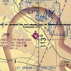
|
| Airport distance calculator |
|---|
|
|
| Sunrise and sunset |
|---|
|
Times for 13-Apr-2026
| | Local
(UTC-7) | | Zulu
(UTC) |
|---|
| Morning civil twilight | | 05:35 | | 12:35 |
| Sunrise | | 06:02 | | 13:02 |
| Sunset | | 19:04 | | 02:04 |
| Evening civil twilight | | 19:30 | | 02:30 |
|
| Current date and time |
|---|
| Zulu (UTC) | 13-Apr-2026 16:37:04 |
|---|
| Local (UTC-7) | 13-Apr-2026 09:37:04 |
|---|
|
| METAR |
|---|
| KAZC | 131615Z AUTO 04003KT 10SM BKN075 BKN090 11/04 A3004 RMK AO2
|
|
| TAF |
|---|
KSGU
28nm W | 131126Z 1312/1412 17006KT P6SM BKN060 FM131800 24012G20KT P6SM SCT060 BKN080 FM140000 25014G22KT P6SM -SHRA BKN080 FM140300 20006KT P6SM -SHRA OVC050 FM140900 16005KT P6SM -SHRA OVC025
|
|
| NOTAMs |
|---|
NOTAMs are issued by the DoD/FAA and will open in a separate window not controlled by AirNav.
|
|

