FAA INFORMATION EFFECTIVE 15 MAY 2025
Location
| FAA Identifier: | BBD |
| Lat/Long: | 31-10-45.4000N 099-19-26.1000W
31-10.756667N 099-19.435000W
31.1792778,-99.3239167
(estimated) |
| Elevation: | 1827.4 ft. / 557.0 m (surveyed) |
| Variation: | 07E (1995) |
| From city: | 3 miles NE of BRADY, TX |
| Time zone: | UTC -5 (UTC -6 during Standard Time) |
| Zip code: | 76825 |
Airport Operations
| Airport use: | Open to the public |
| Activation date: | 08/1941 |
| Control tower: | no |
| ARTCC: | HOUSTON CENTER |
| FSS: | SAN ANGELO FLIGHT SERVICE STATION |
| NOTAMs facility: | SJT (NOTAM-D service available) |
| Attendance: | M-F 0800-1700, ALL SAT-SUN 0900-1300 |
| Wind indicator: | lighted |
| Segmented circle: | yes |
| Lights: | DUSK-DAWN. ACTVT MIRL RWY 17/35 - CTAF. |
| Beacon: | white-green (lighted land airport)
Operates sunset to sunrise. |
Airport Communications
| CTAF/UNICOM: | 122.8 |
| WX AWOS-3: | 118.375 (325-597-9139) |
- APCH/DEP CTL SVC PRVDD BY HOUSTON ARTCC (ZHU) ON FREQS 132.35/317.5 (LOMETA RCAG).
Airport Services
| Fuel available: | 100LL JET-A |
| Parking: | hangars and tiedowns |
| Airframe service: | MAJOR |
| Powerplant service: | MAJOR |
| Bottled oxygen: | NONE |
| Bulk oxygen: | NONE |
Runway Information
Runway 17/35
| Dimensions: | 4605 x 75 ft. / 1404 x 23 m |
| Surface: | asphalt, in good condition |
| Weight bearing capacity: | |
| Runway edge lights: | medium intensity |
| RUNWAY 17 | | RUNWAY 35 |
| Latitude: | 31-11.117943N | | 31-10.358483N |
| Longitude: | 099-19.476780W | | 099-19.479028W |
| Elevation: | 1826.2 ft. | | 1792.5 ft. |
| Traffic pattern: | left | | left |
| Runway heading: | 173 magnetic, 180 true | | 353 magnetic, 000 true |
| Markings: | nonprecision, in good condition | | nonprecision, in good condition |
| Visual slope indicator: | 2-light PAPI on left (3.00 degrees glide path) | | 2-light PAPI on left (3.00 degrees glide path) |
| Touchdown point: | yes, no lights | | yes, no lights |
| Obstructions: | none | | 36 ft. trees, 930 ft. from runway, 135 ft. right of centerline, 20:1 slope to clear |
Runway 8/26
| Dimensions: | 3520 x 110 ft. / 1073 x 34 m |
| Surface: | turf, in fair condition |
| Operational restrictions: | WEST 1240 FT CLSD, 2280 FT RMNG. |
| RUNWAY 8 | | RUNWAY 26 |
| Latitude: | 31-10.799492N | | 31-10.765012N |
| Longitude: | 099-19.717322W | | 099-19.043173W |
| Elevation: | 1812.1 ft. | | 1823.1 ft. |
| Traffic pattern: | left | | left |
| Runway heading: | 086 magnetic, 093 true | | 266 magnetic, 273 true |
| Touchdown point: | yes, no lights | | yes, no lights |
| Obstructions: | 12 ft. fence, 120 ft. from runway, 10:1 slope to clear | | 12 ft. fence, 182 ft. from runway, 15:1 slope to clear |
Airport Ownership and Management from official FAA records
| Ownership: | Publicly-owned |
| Owner: | CITY OF BRADY
PO BOX 351
BRADY, TX 76825
Phone 325-597-2152 |
| Manager: | SCOTT GRIFFIN
3825 N. BRIDGE ST
BRADY, TX 76825
Phone 325-597-1461
AMGR CELL 325-456-1595. |
Additional Remarks
| - | DEER ON & INVOF ARPT. |
| - | FOR CD CTC HOUSTON ARTCC AT 281-230-5622. |
Instrument Procedures
NOTE: All procedures below are presented as PDF files. If you need a reader for these files, you should download the free Adobe Reader.NOT FOR NAVIGATION. Please procure official charts for flight.
FAA instrument procedures published for use from 15 May 2025 at 0901Z to 13 June 2025 at 0900z.
IAPs - Instrument Approach Procedures |
|---|
| RNAV (GPS) RWY 17 | |
download (218KB) |
| RNAV (GPS) RWY 35 | |
download (246KB) |
| NOTE: Special Alternate Minimums apply | |
download (117KB) |
| NOTE: Special Take-Off Minimums/Departure Procedures apply | |
download (294KB) |
Other nearby airports with instrument procedures:
T92 - Mason County Airport (28 nm S)
81R - San Saba County Municipal Airport (31 nm E)
KCOM - Coleman Municipal Airport (40 nm N)
KBWD - Brownwood Regional Airport (41 nm NE)
KAQO - Llano Municipal Airport (42 nm SE)
|
|

Road maps at:
MapQuest
Bing
Google
| Aerial photo |
|---|
WARNING: Photo may not be current or correct
 Taken in August 2005
Do you have a better or more recent aerial photo of Curtis Field Airport that you would like to share? If so, please send us your photo.
|
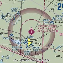
| Sectional chart |
|---|
|
| Airport distance calculator |
|---|
|
|
| Sunrise and sunset |
|---|
|
Times for 17-May-2025
| | Local
(UTC-5) | | Zulu
(UTC) |
|---|
| Morning civil twilight | | 06:15 | | 11:15 |
| Sunrise | | 06:41 | | 11:41 |
| Sunset | | 20:26 | | 01:26 |
| Evening civil twilight | | 20:53 | | 01:53 |
|
| Current date and time |
|---|
| Zulu (UTC) | 17-May-2025 08:26:29 |
|---|
| Local (UTC-5) | 17-May-2025 03:26:29 |
|---|
|
| METAR |
|---|
| KBBD | 170815Z AUTO 14005KT 10SM CLR 23/19 A2987 RMK AO2
|
|
| TAF |
|---|
| KBBD | 170520Z 1706/1806 VRB05KT P6SM BKN250 FM171500 19011KT P6SM BKN250 FM171800 20011KT P6SM SCT050 BKN250 PROB30 1720/1724 P6SM -TSRA BKN040CB FM180000 11007KT P6SM BKN250
|
|
| NOTAMs |
|---|
NOTAMs are issued by the DoD/FAA and will open in a separate window not controlled by AirNav.
|
|


