FAA INFORMATION EFFECTIVE 14 MAY 2026
Location
| FAA Identifier: | BWD |
| Lat/Long: | 31-47-37.0000N 098-57-23.4000W
31-47.616667N 098-57.390000W
31.7936111,-98.9565000
(estimated) |
| Elevation: | 1386.7 ft. / 422.7 m (surveyed) |
| Variation: | 04E (2020) |
| From city: | 5 miles N of BROWNWOOD, TX |
| Time zone: | UTC -5 (UTC -6 during Standard Time) |
| Zip code: | 76802 |
Airport Operations
| Airport use: | Open to the public |
| Control tower: | no |
| ARTCC: | FORT WORTH CENTER |
| FSS: | FORT WORTH FLIGHT SERVICE STATION |
| NOTAMs facility: | BWD (NOTAM-D service available) |
| Attendance: | MON-FRI 0700-1700, ALL SAT-SUN 0700-1500 |
| Wind indicator: | lighted |
| Segmented circle: | yes |
| Lights: | ACTVT MALS RWY 17; MIRL RWY 13/31 & 17/35 - CTAF. |
| Beacon: | white-green (lighted land airport)
Operates sunset to sunrise. |
Airport Communications
| CTAF/UNICOM: | 122.8 |
| WX AWOS-3: | 118.325 (888-297-9399) |
| WX AWOS-3 at MKN (20 nm NE): | 118.575 (325-356-7032) |
- APCH/DEP CTL SVC PRVDD BY FORT WORTH ARTCC (ZFW) ON FREQS 127.45/290.3 (BROWNWOOD RCAG).
Nearby radio navigation aids
| VOR radial/distance | | VOR name | | Freq | | Var |
|---|
| BWDr172/5.9 | | BROWNWOOD VOR/DME | | 113.55 | | 08E |
Airport Services
| Fuel available: | 100LL JET-A
100LL:FUEL 24 HRS SELF SVC. FOR FUEL SVC WHEN UNATNDD CALL 325-643-1482. |
| Parking: | hangars and tiedowns |
| Airframe service: | MAJOR
REPAIRS 325-643-1482 |
| Powerplant service: | MAJOR |
Runway Information
Runway 17/35
| Dimensions: | 5599 x 100 ft. / 1707 x 30 m |
| Surface: | asphalt, in good condition |
| Weight bearing capacity: | |
| Runway edge lights: | medium intensity |
| RUNWAY 17 | | RUNWAY 35 |
| Latitude: | 31-48.113140N | | 31-47.189837N |
| Longitude: | 098-57.304717W | | 098-57.292622W |
| Elevation: | 1384.4 ft. | | 1370.1 ft. |
| Traffic pattern: | left | | left |
| Runway heading: | 175 magnetic, 179 true | | 355 magnetic, 359 true |
| Markings: | nonprecision, in good condition | | nonprecision, in good condition |
| Visual slope indicator: | 4-light PAPI on left (3.00 degrees glide path) | | 4-light PAPI on left (3.00 degrees glide path) |
| Approach lights: | MALS: 1,400 foot medium intensity approach lighting system | | |
| Touchdown point: | yes, no lights | | yes, no lights |
| Instrument approach: | LOCALIZER | | |
| Obstructions: | 33 ft. trees, 1185 ft. from runway, 290 ft. left of centerline, 29:1 slope to clear | | 27 ft. trees, 1100 ft. from runway, 33:1 slope to clear |
Runway 13/31
| Dimensions: | 4608 x 101 ft. / 1405 x 31 m |
| Surface: | asphalt, in good condition |
| Weight bearing capacity: | |
| Runway edge lights: | medium intensity |
| RUNWAY 13 | | RUNWAY 31 |
| Latitude: | 31-47.839992N | | 31-47.309192N |
| Longitude: | 098-57.818638W | | 098-57.181845W |
| Elevation: | 1380.8 ft. | | 1372.1 ft. |
| Traffic pattern: | left | | left |
| Runway heading: | 130 magnetic, 134 true | | 310 magnetic, 314 true |
| Markings: | basic, in good condition | | basic, in good condition |
| Touchdown point: | yes, no lights | | yes, no lights |
| Obstructions: | none | | 52 ft. trees, 1450 ft. from runway, 250 ft. left of centerline, 24:1 slope to clear |
Airport Ownership and Management from official FAA records
| Ownership: | Publicly-owned |
| Owner: | CITY OF BROWNWOOD
BOX 1389
BROWNWOOD, TX 76801
Phone 325-646-5775 |
| Manager: | KYLE WHITLEY
BOX 1389
BROWNWOOD, TX 76801
Phone 325-643-1482 |
Additional Remarks
| - | FOR CD IF UNA TO CTC ON FSS FREQ, CTC FORT WORTH ARTCC AT 817-858-7584. |
Instrument Procedures
NOTE: All procedures below are presented as PDF files. If you need a reader for these files, you should download the free Adobe Reader.NOT FOR NAVIGATION. Please procure official charts for flight.
FAA instrument procedures published for use from 14 May 2026 at 0901Z to 11 June 2026 at 0900Z.
IAPs - Instrument Approach Procedures |
|---|
| RNAV (GPS) RWY 17 | |
download (223KB) |
| RNAV (GPS) RWY 35 | |
download (208KB) |
| LOC RWY 17 **CHANGED** | |
download (237KB) |
| VOR RWY 17 | |
download (190KB) |
| VOR RWY 35 | |
download (191KB) |
| NOTE: Special Alternate Minimums apply | |
download (139KB) |
| NOTE: Special Take-Off Minimums/Departure Procedures apply | |
download (105KB) |
Other nearby airports with instrument procedures:
KMKN - Comanche County-City Airport (20 nm NE)
KCOM - Coleman Municipal Airport (23 nm W)
KGZN - Gregory M Simmons Memorial Airport (35 nm N)
81R - San Saba County Municipal Airport (36 nm S)
KETN - Eastland Municipal Airport (38 nm N)
|
|

Road maps at:
MapQuest
Bing
Google
| Aerial photo |
|---|
WARNING: Photo may not be current or correct
 Photo taken 02-Mar-2006
Do you have a better or more recent aerial photo of Brownwood Regional Airport that you would like to share? If so, please send us your photo.
|
| Sectional chart |
|---|
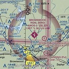
|
| Airport distance calculator |
|---|
|
|
| Sunrise and sunset |
|---|
|
Times for 04-Jun-2026
| | Local
(UTC-5) | | Zulu
(UTC) |
|---|
| Morning civil twilight | | 06:03 | | 11:03 |
| Sunrise | | 06:31 | | 11:31 |
| Sunset | | 20:37 | | 01:37 |
| Evening civil twilight | | 21:05 | | 02:05 |
|
| Current date and time |
|---|
| Zulu (UTC) | 04-Jun-2026 08:04:39 |
|---|
| Local (UTC-5) | 04-Jun-2026 03:04:39 |
|---|
|
| METAR |
|---|
| KBWD | 040755Z AUTO 15007KT 10SM CLR 21/20 A3003 RMK AO2 T02140197 $
|
KMKN
20nm E | 040755Z AUTO 16004KT 10SM CLR 20/18 A3006 RMK AO2 T02020177
|
|
| TAF |
|---|
KBBD
41nm SW | 040520Z 0406/0506 11005KT P6SM BKN250 FM041200 15004KT P6SM OVC018 FM041600 15007KT P6SM BKN030 FM041700 15008KT P6SM BKN040
|
|
| NOTAMs |
|---|
NOTAMs are issued by the DoD/FAA and will open in a separate window not controlled by AirNav.
|
|

