FAA INFORMATION EFFECTIVE 19 MARCH 2026
Location
| FAA Identifier: | BKH |
| Lat/Long: | 22-01-21.9840N 159-47-06.2450W
22-01.366400N 159-47.104083W
22.0227733,-159.7850681
(estimated) |
| Elevation: | 23.2 ft. / 7 m (estimated) |
| Variation: | 10E (2010) |
| From city: | 5 miles NW of KEKAHA,KAUAI, HI |
| Time zone: | UTC -10 (year round; does not observe DST) |
| Zip code: | 96752 |
Airport Operations
| Airport use: | Private use. Permission required prior to landing |
| Control tower: | yes |
| ARTCC: | HONOLULU CONTROL FACILITY CENTER |
| FSS: | HONOLULU FLIGHT SERVICE STATION |
| Attendance: | ALL
OPR 1700-0400Z MON-FRI EXC HOL. OT BY OPR NEC ONLY. |
| Segmented circle: | no |
| Lights: | AVBL ONLY DURING HRS OF OPERATION. |
| Beacon: | white-white-green (lighted military airport)
Operates sunset to sunrise. |
Airport Communications
| UNICOM: | 122.8 |
| ATIS: | 128.0 |
| NAVY BARKING SANDS GROUND: | 124.2 340.2 [0700-1800 MON-FRI EXC HOL, OT BY OPE NEC ONLY.] |
| NAVY BARKING SANDS TOWER: | 126.2 360.2 340.2 [0700-1800 MON-FRI EXC HOL, OT BY OPE NEC ONLY.] |
| EMERG: | 121.5 243.0 |
| RANGE CTL: | 322.85 ;RANGE OUTRIDER 4491 USB |
- APCH/DEP SVC PRVDD BY HONOLULU CONTROL FACILITY (ZHN) ON FREQS 126.5/269.4 (MOUNT KAALA RCAG).
Nearby radio navigation aids
| VOR radial/distance | | VOR name | | Freq | | Var |
|---|
| SOKr286/16.0 | | SOUTH KAUAI VORTAC | | 115.40 | | 11E |
| LIHr267/25.1 | | LIHUE VORTAC | | 113.50 | | 11E |
Airport Services
Runway Information
Runway 16/34
| Dimensions: | 6002 x 150 ft. / 1829 x 46 m |
| Surface: | asphalt |
| Weight bearing capacity: | |
| Runway edge lights: | high intensity |
| RUNWAY 16 | | RUNWAY 34 |
| Latitude: | 22-01.854488N | | 22-00.878313N |
| Longitude: | 159-47.196487W | | 159-47.011683W |
| Elevation: | 23.1 ft. | | 19.5 ft. |
| Traffic pattern: | left | | left |
| Runway heading: | 160 magnetic, 170 true | | 340 magnetic, 350 true |
| Visual slope indicator: | 4-light PAPI on left (3.00 degrees glide path) | | 4-light PAPI on left (3.00 degrees glide path) |
| Touchdown point: | yes, no lights | | yes, no lights |
Airport Ownership and Management from official FAA records
| Ownership: | U.S. Navy |
| Owner: | US NAVY
OCEANOGRAPHIC OFC - CODE 3142
WASHINGTON, DC 20373 |
Additional Remarks
| - | CLNC OBTAINED THRU CO PMRF HAW AREA. PHONE (HON) 471-6311,6254. |
| - | RWY-LGTS: RWY 16 AND RWY 34 - OLS. |
| - | RSTD - 72 HR PPR FOR ALL ACFT, USER REIMBURSE CONTRACTOR OVERTIME, DSN 315-421-6310/6311, C808-335-4310/4311. FOR R3101, CTC RNG OUTRIDER 322.85 OR TWR 126.2 PRIOR TO ENTRY. |
| - | CSTMS/AG/IMG FOR OVERSEAS ARR NOT AVAILABLE ON ROUTINE BASIS. SPECIAL REQUESTS RQR 5 DAYS PN; CTC CBP HONOLULU OFFICE C808-237-4601 TO ARRANGE INSPECTION; AIRCRAFT OPERATOR IS REQUIRED TO PAY EXPENSES. AG INSPECTION AVBL FOR MAINLAND ARR/DEP FLT; 24 HR PN RQR FOR INSPECTION., LIHUE AG C808-632-2511; WKEND/HOL SUBJ TO REIMBURSEMENT OVERTIME FEES. |
| - | MISC - EXTREMELY LTD TOW CAPABILITY; AIRCREW MUST PROVIDE QUALIFIED DRIVER FOR TOW VEH. NO AIR STAIRS. NO LAVATORY SERVICE. NO FLT PLANNING SVC. AERODROME LTD TO MSN ESSENTIAL PAX ONLY. NO SPACE-A SUPPORT. |
| - | SERVICE: FUEL - LTD TO 50K FOR TSNT ACFT AND ONLY DD FORM 1896 (JET FUEL INDENTAPLATE) ACCEPTED. R/W HOT REFUEL RQR CREW MEMBER TO CONNECT FUEL HOSE TO ACFT. R/W (W/SKIDS) AND F/W COLD FUEL ONLY. |
| - | CAUTION (1 OF 2) - NUMEROUS UNLIT OBST WITHIN RWY SAFETY ZONES AND APCH/DEPARTURE CLEAR ZONES. SAND BERMS, TREES AND VEGETATION LOCATED 152' WEST OF CNTRLN EXTENDING FULL LEN OF RWY AND INTO RWY 16 AND 34 APCH ZONES. VEGETATION LOCATED 57' WEST OF PAVEMENT EDGE STRIPES FOR TURN AROUND AREA AT SOUTH END OF RWY. TREES AND VEGETATION LOCATED 250' EAST OF CNTRLN EXTENDING INTO RWY 34 APCH ZONE. KINIKINI DITCH (15' DEEP X 50' WIDE) LOCATED 150' SOUTH OF RUNWAY 34 THLD EXTENDING FR OCEAN AROUND THE RWY TO THE EAST WITH ROUTINE BIRD ACT. VEGETATION LOCATED 135' NORTH OF RWY 16 THLD EXTENDING INTO RWY 16 APCH ZONE. AIRCRAFT ON TWY ALPHA AT RWY HOLD POSN ARE WITHIN THE RWY 16/34 APCH/DEPARTURE CLEAR ZONES. NO TWY GUIDANCE SIGNS; REQ PROGRESSIVE TAXI IF REQRD. USE CAUTION FOR REDUCED BRAKING ACTION ON ALL TWYS AND APRONS DUR DRY CONDS, USE EXTRA CAUTION DUR WET CONDITIONS. TWY BRAVO PCN 31 F/A/W/T; 65' WIDE, LIMITED TO C-130 (WINGSPAN 134') OR SMALLER AIRCRAFT, AND UNLIT, 2' TALL OBST (PENTAGRAPH REFUELING PIPE) LOCATED 34' EAST OF CNTRLN ADJ TO HELIPAD 4. AIRCRAFT CARRYING HAZARDOUS CARGO RSTD TO PCN 41 F/A/W/T DUE TO TWY ALPHA LOAD BRG CHANGE NORTH OF TOWER APRON. FTR PARKING PCN 36 F/A/W/T. NAVY LINE PARKING PCN 31 F/A/W/T. |
| - | CAUTION (2 OF 2) - TWR APN PCN 51 F/A/W/T; CONC PORTION PCN 49 R/C/W/T. FRESH WATER RINSE FACILITY LCTD AT N END OF CONC PORTION. AIRCRAFT WASH RACK PCN 31 F/A/W/T LCTD ADJ TO FABRIC HGR. HELIPAD 1 (100'X100') LTD TO LOCALLY ASSIGNED AIRCRAFT. HELIPADS 2 AND 3 (70'X70') LCTD ON TWY ALPHA ADJ TO NAVY LINE PARKING APRON. HELIPAD 4 (59'X59') LCTD ON TWY BRAVO AND USED FOR HOT REFUEL. |
| - | SERVICE LGT: PAPI RY 16/34 INSTALLED WITH 3 DEGREE GLIDE ANGLE AND 40 FT TCH FOR ACFT W/WHEEL TO COCKPIT HEIGHT OF 10 FT OR LESS. |
| - | CAUTION: EXTV R/W EXTERNAL LOAD TFC. |
| - | AIRFIELD RESTRICTED TO GROSS WEIGHT CAT 2 (ALL UP WEIGHT 60000) UNTIL FURTHER NOTICE PER ARPT MGR. |
| - | FOR CD CTC HONOLULU CONTROL FACILITY AT 808-840-6262. |
| - | SERVICE: JASU - 2(AM32-108). |
| - | NS ABTMT - N SHORELINE KAUAI AND THE ISLAND OF NIHAU EXTREMELY NOISE SENSITIVE, ACFT AVOID BY AT LEAST 5 NM. |
| - | A+ AVBL 1700-0430Z MON-FRI, CLSD SAT, SUN AND HOL. |
| - | CAUTION - EXTV R/W EXTERNAL LOAD TFC. BIRD HAZ. |
| - | MISC - CRASH CREW CAN NML PROVIDE CAT 2 MIN RESPONSE, LTD CAT 3 MIN RESPONSE AVBL. |
Instrument Procedures
NOTE: All procedures below are presented as PDF files. If you need a reader for these files, you should download the free Adobe Reader.NOT FOR NAVIGATION. Please procure official charts for flight.
FAA instrument procedures published for use from 19 March 2026 at 0901Z to 16 April 2026 at 0900Z.
IAPs - Instrument Approach Procedures |
|---|
| RNAV (GPS) RWY 16 | |
download (84KB) |
| RNAV (GPS) RWY 34 | |
download (79KB) |
| HI-TACAN RWY 16 | |
download (207KB) |
| HI-TACAN Z RWY 34 | |
download (205KB) |
| TACAN Y RWY 34 | |
download (190KB) |
Departure Procedures |
|---|
| KEKAHA SIX (RNAV) | |
download (75KB) |
| SOUTH KAUAI SEVEN | |
download (84KB) |
| NOTE: Special Take-Off Minimums/Departure Procedures apply | |
download (197KB) |
Other nearby airports with instrument procedures:
PHLI - Lihue Airport (25 nm E)
|
|

Road maps at:
MapQuest
Bing
Google
| Aerial photo |
|---|
WARNING: Photo may not be current or correct

Do you have a better or more recent aerial photo of Barking Sands Pacific Missile Range Facility Airport that you would like to share? If so, please send us your photo.
|
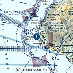
| Sectional chart |
|---|
|
| Airport distance calculator |
|---|
|
|
| Sunrise and sunset |
|---|
|
Times for 14-Apr-2026
| | Local
(UTC-10) | | Zulu
(UTC) |
|---|
| Morning civil twilight | | 05:58 | | 15:58 |
| Sunrise | | 06:21 | | 16:21 |
| Sunset | | 18:58 | | 04:58 |
| Evening civil twilight | | 19:20 | | 05:20 |
|
| Current date and time |
|---|
| Zulu (UTC) | 14-Apr-2026 17:30:30 |
|---|
| Local (UTC-10) | 14-Apr-2026 07:30:30 |
|---|
|
| METAR |
|---|
PHBK
3nm N | 141651Z AUTO 00000KT 10SM BKN095 24/21 A3002 RMK AO2 SLP166 T02390206 $
|
|
| TAF |
|---|
PHLI
25nm E | 141120Z 1412/1512 VRB06KT P6SM FEW015 SCT100 FM142000 18010KT P6SM FEW030 SCT050 FM150600 VRB05KT P6SM VCSH SCT020 BKN040
|
|
| NOTAMs |
|---|
NOTAMs are issued by the DoD/FAA and will open in a separate window not controlled by AirNav.
|
|

