FAA INFORMATION EFFECTIVE 14 MAY 2026
Location
| FAA Identifier: | LIH |
| Lat/Long: | 21-58-33.5400N 159-20-20.2480W
21-58.559000N 159-20.337467W
21.9759833,-159.3389578
(estimated) |
| Elevation: | 152.4 ft. / 46.5 m (surveyed) |
| Variation: | 11E (1990) |
| From city: | 2 miles E of LIHUE, HI |
| Time zone: | UTC -10 (year round; does not observe DST) |
| Zip code: | 96766 |
Airport Operations
| Airport use: | Open to the public |
| Activation date: | 03/1950 |
| Control tower: | yes |
| ARTCC: | HONOLULU CONTROL FACILITY CENTER |
| FSS: | HONOLULU FLIGHT SERVICE STATION |
| NOTAMs facility: | LIH (NOTAM-D service available) |
| Attendance: | 0600-2200 |
| Pattern altitude: | TPA SINGLE ENGINE 1000 (851) MULTI ENGINE 1500 (1351). |
| Wind indicator: | lighted |
| Segmented circle: | yes |
| Lights: | WHEN ATCT CLSD ACTVT MALSR RWY 35; REIL RWYS 03, 17, & 21; PAPI RWYS 03, 17, 21, & 35; MIRL RWY 03/21; HIRL RWY 17/35; TWY LGTS - CTAF. |
| Beacon: | white-green (lighted land airport)
Operates sunset to sunrise. |
| Fire and rescue: | ARFF index C |
| Airline operations: | CRASH & FIRE EQUIPMENT AVBL 24 HRS. |
| International operations: | customs landing rights airport |
Airport Communications
| CTAF: | 118.9 |
| ATIS: | 127.2 |
| WX ASOS: | 127.2 (808-855-3098) |
| LIHUE GROUND: | 121.9 [0600-2200] |
| LIHUE TOWER: | 118.9 263.1 [0600-2200] |
| HCF CENTER APPROACH: | 134.0 ;CTC HCF WHEN LIH TWR CLSD AND |
| HCF CENTER DEPARTURE: | 134.0 ;CTC HCF WHEN LIH TWR CLSD AND |
| CLEARANCE DELIVERY: | 134.0 ;CTC HCF WHEN LIH TWR CLSD AND |
| EMERG: | 121.5 243.0 |
| HEL OPS: | 128.4 |
- CD PRVDD BY HONOLULU CONTROL FACILITY ON FREQS 126.5/269.4 (MOUNT KAALA RCAG) WHEN LIHUE TWR (LIH) CLOSED. IF UNABLE ON 126.5/269.4, THEN CTC HCF ON 134.0 (MOUNT KAALA RCAG).
- APCH/DEP CTL SVC PRVDD BY HONOLULU CONTROL FACILITY (HCF) 126.5/269.4 (MOUNT KAALA RCAG) WHEN LIHUE TWR CLSD. IF UNABLE ON 126.5/269.4, CTC HCF 0N 134.0.
Nearby radio navigation aids
| VOR radial/distance | | VOR name | | Freq | | Var |
|---|
| LIH at field | | LIHUE VORTAC | | 113.50 | | 11E |
| SOKr056/11.5 | | SOUTH KAUAI VORTAC | | 115.40 | | 11E |
Airport Services
| Fuel available: | 100 JET-A
100:100 OCTANE FUEL AVBL 0900-1700. FOR JET A FUEL CALL 1-800-776-2138 OR 1-800-821-3122. |
| Parking: | tiedowns |
| Airframe service: | MINOR |
| Powerplant service: | MINOR
HELI MAJOR. |
| Bottled oxygen: | NONE |
| Bulk oxygen: | NONE |
Runway Information
Runway 3/21
| Dimensions: | 6500 x 150 ft. / 1981 x 46 m |
| Surface: | asphalt/grooved, in good condition |
| Weight bearing capacity: | | Single wheel: | 120.0 | | Double wheel: | 250.0 | | Double tandem: | 550.0 | | Dual double tandem: | 1120.0 |
|
| Runway edge lights: | medium intensity |
| RUNWAY 3 | | RUNWAY 21 |
| Latitude: | 21-58.374272N | | 21-59.133297N |
| Longitude: | 159-20.929075W | | 159-20.115105W |
| Elevation: | 152.3 ft. | | 80.2 ft. |
| Traffic pattern: | right | | left |
| Runway heading: | 034 magnetic, 045 true | | 214 magnetic, 225 true |
| Displaced threshold: | no | | 205 ft. |
| Declared distances: | TORA:6500 TODA:6500 ASDA:6500 LDA:6500 | | TORA:6500 TODA:6500 ASDA:6500 LDA:6295 |
| Markings: | nonprecision, in good condition | | nonprecision, in good condition |
| Visual slope indicator: | 4-light PAPI on left (3.00 degrees glide path)
UNUSBL BYD 1.5 NM AND 7 DEGS LEFT OF CNTRLN AND OFFSET 9.5 DEG E OF CNTRLN DUE TO RAPIDLY RISING TRRN. | | 4-light PAPI on left (3.00 degrees glide path) |
| Runway end identifier lights: | yes | | yes |
| Touchdown point: | yes, no lights | | yes, no lights |
| Obstructions: | none | | 4 ft. tree, 200 ft. from runway, 100 ft. right of centerline |
Runway 17/35
| Dimensions: | 6500 x 150 ft. / 1981 x 46 m
DIST RMNG SIGNS LEFT SIDE OF RWY 35. |
| Surface: | asphalt/grooved, in good condition |
| Weight bearing capacity: | | Single wheel: | 120.0 | | Double wheel: | 250.0 | | Double tandem: | 550.0 | | Dual double tandem: | 1120.0 |
|
| Runway edge lights: | high intensity |
| RUNWAY 17 | | RUNWAY 35 |
| Latitude: | 21-58.901007N | | 21-57.827405N |
| Longitude: | 159-20.152728W | | 159-20.152950W |
| Elevation: | 91.2 ft. | | 91.3 ft. |
| Traffic pattern: | left | | right |
| Runway heading: | 169 magnetic, 180 true | | 349 magnetic, 000 true |
| Declared distances: | TORA:6500 TODA:6500 ASDA:6500 LDA:6500 | | TORA:6500 TODA:6500 ASDA:6500 LDA:6500 |
| Markings: | precision, in good condition | | precision, in good condition |
| Visual slope indicator: | 4-light PAPI on left (3.00 degrees glide path)
UNUSBL BYD 5 DEGS RIGHT OF CNTRLN. | | 4-light PAPI on left (3.00 degrees glide path) |
| Approach lights: | | | MALSR: 1,400 foot medium intensity approach lighting system with runway alignment indicator lights |
| Runway end identifier lights: | yes | | |
| Touchdown point: | yes, no lights | | yes, no lights |
| Instrument approach: | | | ILS/DME |
Helipad H1
| Dimensions: | 40 x 40 ft. / 12 x 12 m |
| Surface: | concrete, in good condition |
| Latitude: | 21-58.933333N | | |
| Longitude: | 159-20.808333W | | |
| Elevation: | 144.1 ft. | | |
| Traffic pattern: | left | | left |
| Runway end identifier lights: | no | | |
Helipad H2
| Dimensions: | 40 x 40 ft. / 12 x 12 m |
| Surface: | concrete |
| Latitude: | 21-58.991667N | | |
| Longitude: | 159-20.748333W | | |
| Elevation: | 133.7 ft. | | |
| Traffic pattern: | left | | left |
Helipad H3
| Dimensions: | 40 x 40 ft. / 12 x 12 m |
| Surface: | concrete |
| Latitude: | 21-59.038333N | | |
| Longitude: | 159-20.696667W | | |
| Elevation: | 125.6 ft. | | |
| Traffic pattern: | left | | left |
Airport Ownership and Management from official FAA records
| Ownership: | Publicly-owned
DIST. MGR; STATE OF HAWAII DEPT. OF TRANSPORTATION AIRPORTS DIV. |
| Owner: | HAWAII ST ARPTS DIV
HONOLULU INTL ARPT
HONOLULU, HI 96819
Phone 808-838-8600 |
| Manager: | CRAIG H. DAVIS
3901 MOKULELE LP BOX 6
LIHUE, HI 96766
Phone 808-274-3800 |
Additional Remarks
| A39-03/21 | PCR VALUE: 704/F/A/W/T |
| A39-17/35 | PCR VALUE: 704/F/A/W/T |
| - | STADIUM FLOOD LIGHTS 125 FT AGL/282 FT MSL/ 2400 FT SW FROM RWY 03 THR. |
| - | RWY 17/35 WGT LMT DC10-10 340000 LBS; DC10-30 430000 LBS. |
| - | 405 FT OF RWY 17/35 500 FT SOUTH OF TWY D & RWY 17/35 INT NOT VSB FM ATCT. |
| - | HELICOPTER PADS 1-20 LCTD W OF CONTROL TOWER. |
| - | MISC 2 OF 3: ACFT NEEDING ENG RUNUPS FOR OTR THAN NML START-UP AND TAXI OUT ARE RQRD TO COORD THESE RUNUPS WITH OPS AT 808-651-6255. NML RUNUP AREA IS ON TWY ALPHA NORTH OF TWY B AND ALPHA INT. ACFT ORIENTATION IS DEPENDENT ON WIND AND TWR APVL. |
| - | MISC 3 OF 3: POWER SETTING WILL NOT CAUSE DAMAGE TO LIGHTS AND SIGNS, IF RUN MAY CAUSE DAMAGE AN ALTERNATE LOCATION WILL BE SELECTED. |
| - | MISC 1 OF 3: PPR FOR PARKING ALL TRANSIENT ACFT, CALL ARPT OPS CONTROL (808)651-6255; FAX (808) 241-3939 BTN 1700Z 0230Z, OTHER TIMES (808) 274-3814. MILITARY/CIVILIAN ACFT CARRYING MUNITIONS/HAZMAT MUST COORDINATE ITINERARY NLT 24 HRS PRIOR TO ARRIVAL. |
| - | EXTENSIVE LARGE AND SMALL BIRD ACTIVITY INVOF RYS INCLUDING THE NENE GOOSE. |
| - | FOR CD WHEN ATCT IS CLSD CTC HONOLULU CONTROL FACILITY AT 808-840-6262. |
| - | INTXN DEPS FM TWY D ON RY 17/35 NOT AUTHORIZED. |
| - | PPR FOR TRANSPORTATION OF DIV 1.1, 1.2, 1.3, 1.4 EXPLOSIVES AND HAZMAT IN AND OUT OF ARPT. CALL ARPT OPS AT 808-651-6255. |
| - | MILITARY ACFT MAKE FUEL ARRANGEMENTS BEFORE ARRIVAL. |
| - | DUE TO NONVISIBILITY ATCT UNABLE TO PROVIDE ATC SVC BTN ACFT AND/OR VEHICLES ON TWY B FM 220 FT TO 500 FT S OF TWY D. |
Instrument Procedures
NOTE: All procedures below are presented as PDF files. If you need a reader for these files, you should download the free Adobe Reader.NOT FOR NAVIGATION. Please procure official charts for flight.
FAA instrument procedures published for use from 14 May 2026 at 0901Z to 11 June 2026 at 0900Z.
IAPs - Instrument Approach Procedures |
|---|
| ILS OR LOC RWY 35 | |
download (324KB) |
| RNAV (RNP) Z RWY 21 | |
download (205KB) |
| RNAV (RNP) Z RWY 35 | |
download (222KB) |
| RNAV (GPS) RWY 17 | |
download (253KB) |
| RNAV (GPS) Y RWY 21 | |
download (228KB) |
| RNAV (GPS) Y RWY 35 | |
download (231KB) |
| VOR OR TACAN RWY 21 | |
download (323KB) |
| VOR OR TACAN RWY 35 | |
download (243KB) |
| NOTE: Special Alternate Minimums apply | |
download (149KB) |
Departure Procedures |
|---|
| LIHUE SIX | |
download (144KB) |
| RICHE THREE | |
download (152KB) |
|
|---|
| KAUAI TWO (OBSTACLE) | |
2 pages:
[1] [2] (592KB) |
| NOTE: Special Take-Off Minimums/Departure Procedures apply | |
download (188KB) |
Other nearby airports with instrument procedures:
PHBK - Barking Sands Pacific Missile Range Facility Airport (25 nm W)
PHHI - Wheeler Army Airfield (78 nm E)
PHJR - Kalaeloa Airport (John Rodgers Field) (81 nm SE)
PHNL - Daniel K Inouye International Airport (88 nm SE)
PHNG - Kaneohe Bay Marine Corps Air Station (Marion E Carl Field) (93 nm E)
|
|

Road maps at:
MapQuest
Bing
Google
| Aerial photo |
|---|
WARNING: Photo may not be current or correct

Do you have a better or more recent aerial photo of Lihue Airport that you would like to share? If so, please send us your photo.
|
| Sectional chart |
|---|
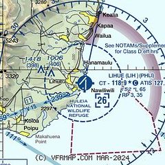
|
CAUTION: Diagram may not be current
 Download PDF
of official airport diagram from the FAA
| Airport distance calculator |
|---|
|
|
| Sunrise and sunset |
|---|
|
Times for 29-May-2026
| | Local
(UTC-10) | | Zulu
(UTC) |
|---|
| Morning civil twilight | | 05:30 | | 15:30 |
| Sunrise | | 05:55 | | 15:55 |
| Sunset | | 19:15 | | 05:15 |
| Evening civil twilight | | 19:39 | | 05:39 |
|
| Current date and time |
|---|
| Zulu (UTC) | 30-May-2026 01:59:04 |
|---|
| Local (UTC-10) | 29-May-2026 15:59:04 |
|---|
|
| METAR |
|---|
| PHLI | 300153Z AUTO 05012KT 10SM FEW025 SCT035 26/19 A3004 RMK AO2 SLP168 T02610194 TSNO
|
|
| TAF |
|---|
| PHLI | 291720Z 2918/3018 06012G20KT P6SM VCSH FEW020 OVC070 FM292000 06012KT P6SM FEW025 SCT035 FM300600 05012KT P6SM SCT025 BKN050
|
|
| NOTAMs |
|---|
NOTAMs are issued by the DoD/FAA and will open in a separate window not controlled by AirNav.
|
|


