FAA INFORMATION EFFECTIVE 15 MAY 2025
Location
| FAA Identifier: | BYS |
| Lat/Long: | 35-16-49.9090N 116-37-48.1060W
35-16.831817N 116-37.801767W
35.2805303,-116.6300294
(estimated) |
| Elevation: | 2350 ft. / 716 m (estimated) |
| Variation: | 14E (1985) |
| From city: | 3 miles NE of central business district of the associated city |
| Time zone: | UTC -7 (UTC -8 during Standard Time) |
| Zip code: | 92310 |
Airport Operations
| Airport use: | Private use. Permission required prior to landing |
| Control tower: | no |
| ARTCC: | LOS ANGELES CENTER |
| FSS: | RIVERSIDE FLIGHT SERVICE STATION |
| Attendance: | CONTINUOUS |
| Segmented circle: | no |
| Beacon: | white-white-green (lighted military airport)
Operates sunset to sunrise. |
Airport Communications
| ADZY: | 118.175 281.45 41.5FM |
| MEDEVAC: | 38.9FM |
| OPS: | 126.2 ;SOUTH 134.1 ;NORTH 302.3 ;NORTH 339.85 ;SOUTH 41.0FM ;SOUTH 41.65FM ;NORTH |
| RANGE CTL: | 32.7FM 38.9FM |
Nearby radio navigation aids
| VOR radial/distance | | VOR name | | Freq | | Var |
|---|
| DAGr337/19.3 | | DAGGETT VORTAC | | 113.20 | | 15E |
| HECr329/30.1 | | HECTOR VORTAC | | 112.70 | | 15E |
Airport Services
Runway Information
Runway 4/22
| Dimensions: | 9631 x 175 ft. / 2936 x 53 m |
| Surface: | gravel |
| Runway edge lights: | low intensity |
| RUNWAY 4 | | RUNWAY 22 |
| Traffic pattern: | left | | left |
Runway 13/31
| Dimensions: | 6124 x 175 ft. / 1867 x 53 m |
| Surface: | gravel |
| RUNWAY 13 | | RUNWAY 31 |
| Traffic pattern: | left | | left |
Airport Ownership and Management from official FAA records
| Ownership: | U.S. Army |
| Owner: | US ARMY AERONAUTICAL SVCS AGENCY
FT BELVOIR, VA 22060 |
Additional Remarks
| - | RSTD: C-17 USE RQRS COMBAT CONTROL TEAM (CCT) OR QUALIFIED TALCE INSPECTION PRIOR TO OPS. ATCT CLSD. PPR 3 BUS/WORKING DAYS EXCLDG WKENDS OR HOLS PRIOR TO ENTERING R2502, DSN 470-4320, C760-380-4320. CTC DESERT RDO (H24) 30 MIN PRIOR TO ENTERING RSTD AREA. |
| - | MISC: WX FCST SVC, BICYCLE LAKE DSN 470-9527, C760-380-9527. REMOTE WX BRIEFING SVC AVBL DAVIS MONTHAN AFB, DSN 228-6598/6599, C520-228-6598/6599. |
| - | LTD FCST SVC, BICYCLE LAKE DSN 470-4328. |
| - | CAUTION: PWR POLES NEAR HIGHWATER PADS AND SW OF RWY 04 THLD UNLGTD. |
| - | SERVICE - LGT: HELIPAD WEST LGTD, NO RWY LGTS 04/22. |
| - | COMMUNICATIONS: PMSV - 69.95, 66.9; ATIS 239.275 (C760-380-7188 NATIONAL TRAINING CTR); DESERT RDO SOUTH - (E) 66.1, 126.2, 267.275; DESERT RDO NORTH - (E) 66.1, 126.2, 302.3; DESERT RDO CENTRAL - (E) 66.1, 126.2, 281.45. |
| - | NATIONAL TRAINING CENTER ATIS 134.100, 760-380-7188. |
| - | FOR CD CTC JOSHUA APCH AT 661-277-3843. |
| - | SVC - FUEL: A++ AVBL H24 RQRS PRIOR APPROVAL CTC DSN 470-6877, C760-380-6877. |
| - | RWY 13/31 CLSD. |
| - | CAUTION: LDG AREAS SUBJECT TO BROWN-OUT CONDS; OCNL BLOWING SAND/DUST. |
| - | MAIN POST HELIPAD RSTRD TO MEDEVAC AND VIP ACFT. |
| - | CAUTION: HI VOLTAGE RADAR TRANS VCNTY MARS LAKE IN GOLDSTONE. |
| - | CAUTION: EXTV LOW LEVEL JET ACT. |
| - | CAUTION: SFC TO SFC AND AIR TO GND GUNNERY. |
Instrument Procedures
There are no published instrument procedures at KBYS.
Some nearby airports with instrument procedures:
KDAG - Barstow-Daggett Airport (27 nm S)
KAPV - Apple Valley Airport (50 nm SW)
KVCV - Southern California Logistics Airport (55 nm SW)
KNID - China Lake Naval Air Weapons Station (Armitage Field) (57 nm NW)
L35 - Big Bear City Airport (62 nm S)
|
|

Road maps at:
MapQuest
Bing
Google
| Aerial photo |
|---|
WARNING: Photo may not be current or correct
 Photo by Kristen Grady
Photo taken 21-Jun-2006
Photo by Kristen Grady
Photo taken 21-Jun-2006
Do you have a better or more recent aerial photo of Bicycle Lake Army Airfield that you would like to share? If so, please send us your photo.
|
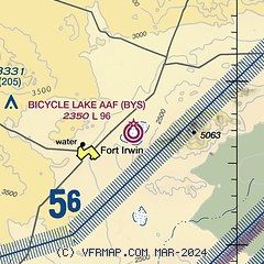
| Sectional chart |
|---|
|
| Airport distance calculator |
|---|
|
|
| Sunrise and sunset |
|---|
|
Times for 18-May-2025
| | Local
(UTC-7) | | Zulu
(UTC) |
|---|
| Morning civil twilight | | 05:13 | | 12:13 |
| Sunrise | | 05:41 | | 12:41 |
| Sunset | | 19:45 | | 02:45 |
| Evening civil twilight | | 20:13 | | 03:13 |
|
| Current date and time |
|---|
| Zulu (UTC) | 18-May-2025 20:16:27 |
|---|
| Local (UTC-7) | 18-May-2025 13:16:27 |
|---|
|
| METAR |
|---|
| KBYS | 181955Z AUTO 00000KT 10SM FEW290 FEW320 24/M03 A2987 RMK AO2 SLPNO T02431031 $
|
|
| NOTAMs |
|---|
NOTAMs are issued by the DoD/FAA and will open in a separate window not controlled by AirNav.
|
|


