FAA INFORMATION EFFECTIVE 14 MAY 2026
Location
| FAA Identifier: | DAG |
| Lat/Long: | 34-51-13.4000N 116-47-12.1000W
34-51.223333N 116-47.201667W
34.8537222,-116.7866944
(estimated) |
| Elevation: | 1930 ft. / 588.3 m (surveyed) |
| Variation: | 15E (1975) |
| From city: | 4 miles E of DAGGETT, CA |
| Time zone: | UTC -7 (UTC -8 during Standard Time) |
| Zip code: | 92327 |
Airport Operations
| Airport use: | Open to the public |
| Activation date: | 05/1941 |
| Control tower: | no |
| ARTCC: | LOS ANGELES CENTER |
| FSS: | RIVERSIDE FLIGHT SERVICE STATION |
| NOTAMs facility: | DAG (NOTAM-D service available) |
| Attendance: | 0630-1700 |
| Wind indicator: | lighted |
| Segmented circle: | yes |
| Lights: | ACTVT MIRL RWY 4/22 & 8/26 - CTAF. PAPI RWY 08, 22, & 26 OPR CONSLY. |
| Beacon: | white-green (lighted land airport)
Operates sunset to sunrise. |
Airport Communications
| CTAF/UNICOM: | 123.0 |
| WX ASOS: | 132.175 (760-254-3630) |
- APCH/DEP CTL SVC PRVDD BY LOS ANGELES ARTCC (ZLA) ON FREQS 132.5/284.7 (BARSTOW RCAG).
Nearby radio navigation aids
| VOR radial/distance | | VOR name | | Freq | | Var |
|---|
| DAGr223/12.2 | | DAGGETT VORTAC | | 113.20 | | 15E |
| HECr267/16.3 | | HECTOR VORTAC | | 112.70 | | 15E |
| VCVr048/33.6 | | VICTORVILLE VOR/DME | | 109.05 | | 14E |
Airport Services
| Fuel available: | 100LL JET-A |
| Parking: | tiedowns |
| Bottled oxygen: | NONE |
| Bulk oxygen: | NONE |
Runway Information
Runway 8/26
| Dimensions: | 6402 x 150 ft. / 1951 x 46 m |
| Surface: | asphalt, in fair condition |
| Weight bearing capacity: | | Single wheel: | 30.0 | | Double wheel: | 170.0 | | Double tandem: | 320.0 |
|
| Runway edge lights: | medium intensity |
| RUNWAY 8 | | RUNWAY 26 |
| Latitude: | 34-51.088997N | | 34-51.088997N |
| Longitude: | 116-47.870240W | | 116-46.590018W |
| Elevation: | 1930.0 ft. | | 1908.6 ft. |
| Traffic pattern: | left | | left |
| Runway heading: | 075 magnetic, 090 true | | 255 magnetic, 270 true |
| Markings: | basic, in fair condition | | basic, in good condition |
| Visual slope indicator: | 4-light PAPI on left (3.00 degrees glide path) | | 4-light PAPI on left (3.00 degrees glide path) |
| Runway end identifier lights: | no | | no |
| Touchdown point: | yes, no lights | | yes, no lights |
Runway 4/22
| Dimensions: | 5123 x 100 ft. / 1561 x 30 m |
| Surface: | asphalt, in fair condition |
| Weight bearing capacity: | | Single wheel: | 30.0 | | Double wheel: | 105.0 | | Double tandem: | 190.0 |
|
| Runway edge lights: | medium intensity |
| RUNWAY 4 | | RUNWAY 22 |
| Latitude: | 34-51.122092N | | 34-51.659075N |
| Longitude: | 116-47.560567W | | 116-46.769943W |
| Elevation: | 1922.9 ft. | | 1908.7 ft. |
| Traffic pattern: | left | | left |
| Runway heading: | 036 magnetic, 051 true | | 216 magnetic, 231 true |
| Markings: | basic, in fair condition | | nonprecision, in good condition |
| Visual slope indicator: | | | 4-light PAPI on left (3.00 degrees glide path) |
| Runway end identifier lights: | no | | no |
| Touchdown point: | yes, no lights | | yes, no lights |
Airport Ownership and Management from official FAA records
| Ownership: | Publicly-owned |
| Owner: | COUNTY OF SAN BERNARDINO
268 HOSPITALITY LANE, SUITE 302
SAN BERNARDINO, CA 92415
Phone 909-387-8810 |
| Manager: | TESS COOK
21600 CORWIN ROAD
APPLE VALLEY, CA 92307
Phone 909-327-8740 |
Additional Remarks
| - | E-W TWY PARALLEL TO RWY 08/26 WT BRG CPTY LIMITED TO S-12. |
| - | PAEW INVOF ARMY RAMP. EXTSV MILITARY HELICOPTER TRAFFIC INVOF ARPT. |
| - | FOR CD IF UNA TO CTC ON FSS FREQ, CTC LOS ANGELES ARTCC AT 661-575-2079. |
Instrument Procedures
NOTE: All procedures below are presented as PDF files. If you need a reader for these files, you should download the free Adobe Reader.NOT FOR NAVIGATION. Please procure official charts for flight.
FAA instrument procedures published for use from 14 May 2026 at 0901Z to 11 June 2026 at 0900Z.
IAPs - Instrument Approach Procedures |
|---|
| RNAV (GPS) RWY 22 | |
download (210KB) |
| RNAV (GPS) RWY 26 | |
download (292KB) |
| VOR OR TACAN RWY 22 | |
download (225KB) |
| NOTE: Special Alternate Minimums apply | |
download (33KB) |
|
|---|
| DAGGETT ONE (OBSTACLE) | |
download (310KB) |
| NOTE: Special Take-Off Minimums/Departure Procedures apply | |
download (132KB) |
Other nearby airports with instrument procedures:
KAPV - Apple Valley Airport (26 nm SW)
KVCV - Southern California Logistics Airport (33 nm SW)
L35 - Big Bear City Airport (36 nm S)
KREI - Redlands Municipal Airport (49 nm S)
KSBD - San Bernardino International Airport (51 nm SW)
|
|

Road maps at:
MapQuest
Bing
Google
| Aerial photo |
|---|
WARNING: Photo may not be current or correct
 Photo by focalflight.com
Photo taken 09-Dec-2015
looking west.
Photo by focalflight.com
Photo taken 09-Dec-2015
looking west.
Do you have a better or more recent aerial photo of Barstow-Daggett Airport that you would like to share? If so, please send us your photo.
|
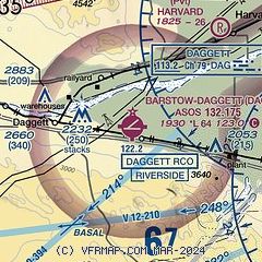
| Sectional chart |
|---|
|
 Download PDF
of official airport diagram from the FAA
| Airport distance calculator |
|---|
|
|
| Sunrise and sunset |
|---|
|
Times for 26-May-2026
| | Local
(UTC-7) | | Zulu
(UTC) |
|---|
| Morning civil twilight | | 05:09 | | 12:09 |
| Sunrise | | 05:38 | | 12:38 |
| Sunset | | 19:50 | | 02:50 |
| Evening civil twilight | | 20:19 | | 03:19 |
|
| Current date and time |
|---|
| Zulu (UTC) | 26-May-2026 20:10:50 |
|---|
| Local (UTC-7) | 26-May-2026 13:10:50 |
|---|
|
| METAR |
|---|
| KDAG | 261950Z AUTO 30025G36KT 10SM CLR 25/06 A2968 RMK AO2 PK WND 31036/1946 SLP027 T02500056
|
|
| TAF |
|---|
| KDAG | 261720Z 2618/2718 26023G32KT P6SM FEW250 FM262200 26028G42KT P6SM SCT250 FM271000 24020G28KT P6SM FEW250
|
|
| NOTAMs |
|---|
NOTAMs are issued by the DoD/FAA and will open in a separate window not controlled by AirNav.
|
|


