FAA INFORMATION EFFECTIVE 19 FEBRUARY 2026
Location
| FAA Identifier: | CDC |
| Lat/Long: | 37-42-03.4920N 113-05-55.8630W
37-42.058200N 113-05.931050W
37.7009700,-113.0988508
(estimated) |
| Elevation: | 5622.3 ft. / 1713.7 m (surveyed) |
| Variation: | 14E (1990) |
| From city: | 2 miles NW of CEDAR CITY, UT |
| Time zone: | UTC -7 (UTC -6 during Daylight Saving Time) |
| Zip code: | 84720 |
Airport Operations
| Airport use: | Open to the public |
| Activation date: | 01/1938 |
| Control tower: | no |
| ARTCC: | SALT LAKE CITY CENTER |
| FSS: | CEDAR CITY FLIGHT SERVICE STATION |
| NOTAMs facility: | CDC (NOTAM-D service available) |
| Attendance: | DAYLIGHT HOURS
FOR AFT HRS SVC CALL 435-586-4504 |
| Pattern altitude: | 6399.3 ft. MSL |
| Wind indicator: | lighted |
| Segmented circle: | yes |
| Lights: | ACTVT MALSR RWY 20; REIL RWY 02, 08 & 26; HIRL RWY 02/20; MIRL RWY 08/26 - CTAF. PAPI RWY 02 & 20, 08 OPER CONSLY. |
| Beacon: | white-green (lighted land airport)
Operates sunset to sunrise. |
| Fire and rescue: | ARFF index A |
| Airline operations: | CLSD TO UNSKED ACR OPNS WITH MORE THAN 30 PSGR SEATS EXCP 24 HR PPR CALL CC FIRE DEPT 435-586-2964 AND AMGR 435-867-9408. |
Airport Communications
| CTAF/UNICOM: | 123.0 |
| WX ASOS: | 119.025 (435-867-0278) |
- APCH/DEP CTL SVC PRVDD BY SALT LAKE ARTCC (ZLC) ON 125.575/379.275 (CEDAR CITY RCAG).
Nearby radio navigation aids
| VOR radial/distance | | VOR name | | Freq | | Var |
|---|
| EHKr180/5.4 | | ENOCH VOR/DME | | 117.30 | | 16E |
| BCEr256/37.7 | | BRYCE CANYON VORTAC | | 112.80 | | 15E |
| MLFr170/39.8 | | MILFORD VORTAC | | 112.10 | | 16E |
Airport Services
| Fuel available: | 100LL JET-A
100LL:100LL FUEL AVBL 24 HRS SELF-SVC CREDIT CARD SYSTEM. |
| Parking: | hangars and tiedowns |
| Airframe service: | MAJOR |
| Powerplant service: | MAJOR |
| Bottled oxygen: | HIGH/LOW |
Runway Information
Runway 2/20
| Dimensions: | 8653 x 150 ft. / 2637 x 46 m |
| Surface: | asphalt/grooved, in good condition |
| Weight bearing capacity: | | Single wheel: | 56.0 | | Double wheel: | 76.0 | | Double tandem: | 127.0 | | Dual double tandem: | 142.0 |
|
| Runway edge lights: | high intensity |
| RUNWAY 2 | | RUNWAY 20 |
| Latitude: | 37-41.436600N | | 37-42.614633N |
| Longitude: | 113-06.469118W | | 113-05.459232W |
| Elevation: | 5579.8 ft. | | 5605.3 ft. |
| Traffic pattern: | left | | right |
| Runway heading: | 020 magnetic, 034 true | | 200 magnetic, 214 true |
| Declared distances: | TORA:8653 TODA:8653 ASDA:8653 LDA:8653 | | TORA:8653 TODA:8653 ASDA:8653 LDA:8653 |
| Markings: | nonprecision, in good condition | | precision, in good condition |
| Visual slope indicator: | 4-light PAPI on left (3.00 degrees glide path) | | 4-light PAPI on left (3.00 degrees glide path) |
| Approach lights: | | | MALSR: 1,400 foot medium intensity approach lighting system with runway alignment indicator lights |
| Runway end identifier lights: | yes | | |
| Touchdown point: | yes, no lights | | yes, no lights |
| Instrument approach: | | | ILS |
Runway 8/26
| Dimensions: | 4822 x 60 ft. / 1470 x 18 m |
| Surface: | asphalt, in fair condition |
| Weight bearing capacity: | |
| Runway edge lights: | medium intensity |
| Operational restrictions: | RWY 08/26 NOT AVBL FOR PART 121/PART 380 OPS WITH SKED PAX CARRYING OPS MORE THAN 9 PAX SEATS AND NON-SKED PAX CARRYING OPS MORE THAN 30 PAX SEATS. |
| RUNWAY 8 | | RUNWAY 26 |
| Latitude: | 37-42.163680N | | 37-42.069545N |
| Longitude: | 113-06.367785W | | 113-05.375153W |
| Elevation: | 5578.6 ft. | | 5622.3 ft. |
| Traffic pattern: | left | | right |
| Runway heading: | 083 magnetic, 097 true | | 263 magnetic, 277 true |
| Declared distances: | TORA:4822 TODA:4822 ASDA:4822 LDA:4822 | | TORA:4822 TODA:4822 ASDA:4822 LDA:4822 |
| Markings: | basic, in good condition | | basic, in good condition |
| Visual slope indicator: | 4-light PAPI on left (3.00 degrees glide path) | | |
| Runway end identifier lights: | yes | | yes |
| Touchdown point: | yes, no lights | | yes, no lights |
| Obstructions: | 40 ft. pole, 1800 ft. from runway, 40:1 slope to clear
40 FT POLES ON EXTNDD RWY CNTRLN. | | 18 ft. road, 661 ft. from runway, 26:1 slope to clear |
Airport Ownership and Management from official FAA records
| Ownership: | Publicly-owned |
| Owner: | CEDAR CITY CORPORATION
10 NORTH MAIN
CEDAR CITY, UT 84720
Phone 435-586-2950 |
| Manager: | TYLER GALETKA
2560 AVIATION WAY
CEDAR CITY, UT 84721
Phone 435-867-9408 |
Additional Remarks
| A39-02/20 | PCR VALUE: 410/F/B/X/T |
| A39-08/26 | PCR VALUE: 40/F/B/X/T |
| - | GA ACFT NOT PERMITTED ON ACR RAMP. |
| - | AUTOROTATE - NO AUTOROTATION TRNG TO HELIPAD. RWY 02/20 CLSD TO HEL RUN-ON LNDG; RWY 08/26 CLSD TO HEL RUN-ON LNDG; TWY A, N OF RWY 8/26 CLSD TO HEL RUN-ON LNDG; TWY C CLSD TO HEL RUN-ON LNDG. |
| - | RWY 02 LEFT TRAFFIC PATTERN EXC HELICOPTERS. RWY 20 RIGHT TRAFFIC EXC HELICOPTERS. |
| - | FOR CD IF UNA TO CTC ON FSS FREQ, CTC SALT LAKE ARTCC AT 801-320-2568. |
| - | TWY B CLSD BTWN TWY C & EAST APRON |
| - | RECOMMNED PILOTS CIRCLE ARPT FOR ALT BEFORE DEPARTING EASTBOUND DUE TO FAST RISING TERRAIN AND HI DENSITY ALT. TURBC LIKELY INVOF MNTS & PASSES. |
| - | TWY B NOT AVBL FOR ACR ACFT. |
| - | DESIGNATED CALM WIND RWY (BLW 5 KTS) IS RWY 20, RGT TFC. |
| - | UNMON SFC CONDS 1900-0700 DLY EXC FOR SKED ACR. |
| - | EXTENSIVE HELICOPTER ACTIVITY. |
| - | EXTENSIVE FLIGHT TRNG INVOF ARPT. |
Instrument Procedures
NOTE: All procedures below are presented as PDF files. If you need a reader for these files, you should download the free Adobe Reader.NOT FOR NAVIGATION. Please procure official charts for flight.
FAA instrument procedures published for use from 19 February 2026 at 0901Z to 19 March 2026 at 0900Z.
IAPs - Instrument Approach Procedures |
|---|
| ILS OR LOC RWY 20 | |
download (482KB) |
| RNAV (GPS) RWY 02 | |
download (372KB) |
| RNAV (GPS) RWY 20 | |
download (379KB) |
| VOR RWY 20 | |
download (299KB) |
| NOTE: Special Alternate Minimums apply | |
download (118KB) |
| NOTE: Special Take-Off Minimums/Departure Procedures apply | |
download (803KB) |
Other nearby airports with instrument procedures:
U55 - Panguitch Municipal Airport (35 nm E)
U52 - Beaver Municipal Airport (38 nm NE)
KMLF - Milford Municipal Airport/Ben and Judy Briscoe Field (44 nm N)
KSGU - St George Regional Airport (44 nm SW)
KAZC - Colorado City Municipal Airport (45 nm S)
|
|

Road maps at:
MapQuest
Bing
Google
| Aerial photo |
|---|
WARNING: Photo may not be current or correct
 Photo courtesy of focalflight.com
Photo taken 09-Dec-2015
looking north.
Photo courtesy of focalflight.com
Photo taken 09-Dec-2015
looking north.
Do you have a better or more recent aerial photo of Cedar City Regional Airport that you would like to share? If so, please send us your photo.
|
| Sectional chart |
|---|
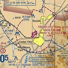
|
| Airport distance calculator |
|---|
|
|
| Sunrise and sunset |
|---|
|
Times for 20-Feb-2026
| | Local
(UTC-7) | | Zulu
(UTC) |
|---|
| Morning civil twilight | | 06:50 | | 13:50 |
| Sunrise | | 07:17 | | 14:17 |
| Sunset | | 18:16 | | 01:16 |
| Evening civil twilight | | 18:42 | | 01:42 |
|
| Current date and time |
|---|
| Zulu (UTC) | 20-Feb-2026 13:13:37 |
|---|
| Local (UTC-7) | 20-Feb-2026 06:13:37 |
|---|
|
| METAR |
|---|
| KCDC | 201253Z AUTO 34006KT 1 1/4SM -SN BR FEW007 OVC015 M04/M04 A2964 RMK AO2 SLP052 P0002 T10391044
|
|
| TAF |
|---|
| KCDC | 201130Z 2012/2112 22009KT 3SM -SN SCT010 OVC020 TEMPO 2012/2014 1/2SM SN FG OVC008 FM201400 32009KT P6SM SCT020 BKN040 TEMPO 2014/2016 1SM -SN OVC012 FM201800 32006KT P6SM SCT040 FM210100 16005KT P6SM FEW120
|
|
| NOTAMs |
|---|
NOTAMs are issued by the DoD/FAA and will open in a separate window not controlled by AirNav.
|
|


