FAA INFORMATION EFFECTIVE 22 JANUARY 2026
Location
| FAA Identifier: | CLL |
| Lat/Long: | 30-35-16.9508N 096-21-45.1600W
30-35.282513N 096-21.752667W
30.5880419,-96.3625444
(estimated) |
| Elevation: | 320.6 ft. / 97.7 m (surveyed) |
| Variation: | 03E (2020) |
| From city: | 3 miles SW of COLLEGE STATION, TX |
| Time zone: | UTC -6 (UTC -5 during Daylight Saving Time) |
| Zip code: | 77845 |
Airport Operations
| Airport use: | Open to the public |
| Activation date: | 05/1940 |
| Control tower: | yes |
| ARTCC: | HOUSTON CENTER |
| FSS: | MONTGOMERY COUNTY FLIGHT SERVICE STATION |
| NOTAMs facility: | CLL (NOTAM-D service available) |
| Attendance: | 0600-2200 |
| Wind indicator: | lighted |
| Segmented circle: | no |
| Lights: | WHEN ATCT CLSD ACTVT MALSR RWY 35; MIRL RWY 11/29; HIRL RWY 17/35 - CTAF. REIL RWY 29 PRESET LOW INTST ONLY. |
| Beacon: | white-green (lighted land airport)
Operates sunset to sunrise. |
| Fire and rescue: | ARFF index B |
| Airline operations: | CLSD TO UNSKED ACR OPNS WITH MORE THAN 30 PSGR SEATS EXCP 24 HRS PPR CALL AMGR 979-775-9920. |
Airport Communications
| CTAF: | 118.5 |
| UNICOM: | 122.95 |
| ATIS: | 126.85 |
| WX ASOS: | PHONE 979-846-1708 |
| EASTERWOOD GROUND: | 128.7 284.7 [0800-2100] |
| EASTERWOOD TOWER: | 118.5 284.7 [0800-2100] |
| HOUSTON APPROACH: | 134.3 |
| HOUSTON DEPARTURE: | 134.3 |
| CLEARANCE DELIVERY: | 128.7 120.4 ;WHEN TWR CLSD |
| EMERG: | 121.5 243.0 |
| WX AWOS-3PT at CFD (8 nm N): | 125.975 (979-778-2544) |
| WX AWOS-3PT at RWV (18 nm W): | 118.35 (979-567-6784) |
| WX AWOS-3PT at 60R (19 nm SE): | 120.925 (936-825-0798) |
Nearby radio navigation aids
| VOR radial/distance | | VOR name | | Freq | | Var |
|---|
| CLLr101/3.2 | | COLLEGE STATION VORTAC | | 113.30 | | 08E |
| TNVr311/23.9 | | NAVASOTA VOR/DME | | 115.90 | | 08E |
| LOAr204/38.0 | | LEONA VORTAC | | 110.80 | | 08E |
| NDB name | | Hdg/Dist | | Freq | | Var | | ID |
|---|
| ROWDY | | 344/5.8 | | 260 | | 03E | | CL | -.-. .-.. |
Airport Services
| Fuel available: | 100LL JET-A JET-A+
100LL:FUEL SVC 0600-2200. FOR FUEL AFT HRS PPR CALL 979-775-5255. LATE NIGHT FEE. |
| Parking: | hangars and tiedowns |
| Airframe service: | MAJOR |
| Powerplant service: | MAJOR |
Runway Information
Runway 17/35
| Dimensions: | 7000 x 146 ft. / 2134 x 45 m |
| Surface: | asphalt/concrete/grooved, in excellent condition
FIRST 1850 FT RWY 35 CONC. |
| Weight bearing capacity: | | Single wheel: | 78.0 | | Double wheel: | 94.0 | | Double tandem: | 156.0 |
|
| Runway edge lights: | high intensity |
| RUNWAY 17 | | RUNWAY 35 |
| Latitude: | 30-35.798365N | | 30-34.665355N |
| Longitude: | 096-21.771275W | | 096-21.513890W |
| Elevation: | 320.6 ft. | | 304.3 ft. |
| Traffic pattern: | left | | left |
| Runway heading: | 166 magnetic, 169 true | | 346 magnetic, 349 true |
| Declared distances: | TORA:7000 TODA:7000 ASDA:7000 LDA:7000 | | TORA:7000 TODA:7000 ASDA:6932 LDA:6932 |
| Markings: | precision, in good condition | | precision, in good condition |
| Visual slope indicator: | 4-box VASI on right (3.00 degrees glide path) | | |
| Approach lights: | | | MALSR: 1,400 foot medium intensity approach lighting system with runway alignment indicator lights |
| Touchdown point: | yes, no lights | | yes, no lights |
| Instrument approach: | | | ILS/DME |
| Obstructions: | 42 ft. tree, 500 ft. from runway, 480 ft. right of centerline, 7:1 slope to clear | | none |
Runway 11/29
| Dimensions: | 5158 x 150 ft. / 1572 x 46 m |
| Surface: | asphalt/grooved, in excellent condition |
| Weight bearing capacity: | | Single wheel: | 37.0 | | Double wheel: | 49.0 |
|
| Runway edge lights: | medium intensity |
| RUNWAY 11 | | RUNWAY 29 |
| Latitude: | 30-35.488247N | | 30-35.214263N |
| Longitude: | 096-22.367657W | | 096-21.436470W |
| Elevation: | 319.4 ft. | | 311.4 ft. |
| Traffic pattern: | left | | left |
| Runway heading: | 106 magnetic, 109 true | | 286 magnetic, 289 true |
| Declared distances: | TORA:5158 TODA:5158 ASDA:5158 LDA:5158 | | TORA:5158 TODA:5158 ASDA:5158 LDA:5158 |
| Markings: | nonprecision, in good condition | | nonprecision, in good condition |
| Visual slope indicator: | 4-box VASI on left (3.00 degrees glide path) | | 4-box VASI on left (3.00 degrees glide path) |
| Runway end identifier lights: | | | yes |
| Touchdown point: | yes, no lights | | yes, no lights |
| Obstructions: | 40 ft. tree, 1180 ft. from runway, 400 ft. right of centerline, 24:1 slope to clear | | 18 ft. tree, 500 ft. from runway, 230 ft. left of centerline, 17:1 slope to clear |
Airport Ownership and Management from official FAA records
| Ownership: | Publicly-owned |
| Owner: | TEXAS A&M UNIVERSITY
301 TARROW STREET
COLLEGE STATION, TX 77840
Phone (979) 775-9900 |
| Manager: | KEVIN DAVIS
1 MCKENZIE TERMINAL BLVD, SUITE 112
COLLEGE STATION, TX 77845
Phone 979-775-9901 |
Additional Remarks
| A39-11/29 | PCR VALUE: 570/F/D/X/T |
| A39-17/35 | PCR VALUE: 300/R/D/W/T |
| - | ALL RAPID RFL MIL HEL ADZ ATC FOR RAPID RFL OPS & PROCD TO SOUTH RAMP. CTC ASTIN AVN UNICOM 122.95 FOR SVC PRIOR TO LNDG. RAPID RFL IS AVBL 0600-2200 DLY. SPL RQS CSDRD ON CASE BY CASE BASIS. |
| - | FOR CD IF UNA TO CTC ON FSS FREQ, CTC HOUSTON ARTCC AT 281-230-5622. |
| - | ALL ACFT PRKG ON SE RAMP MUST CTC ASTIN AVN FOR SVC OR TRNSP, UNICOM 122.95 OR 979-775-5255. |
| - | TURN FEE SKEDD FAR 135 AND ALL FAR 121 OPNS. |
| - | PAEW ADJ ALL RWYS AND TWYS 0600-1600. |
| - | SFC COND NOT RPRTD FM 1700-0500 LCA MON-FRI AND SAT-SUN. |
| - | (CONTACT PHONE NR) CABBOTT@EASTERWOODAIRPORT.COM |
Instrument Procedures
NOTE: All procedures below are presented as PDF files. If you need a reader for these files, you should download the free Adobe Reader.NOT FOR NAVIGATION. Please procure official charts for flight.
FAA instrument procedures published for use from 22 January 2026 at 0901Z to 19 February 2026 at 0900z.
IAPs - Instrument Approach Procedures |
|---|
| ILS OR LOC RWY 35 | |
download (280KB) |
| RNAV (GPS) RWY 11 | |
download (188KB) |
| RNAV (GPS) RWY 17 | |
download (195KB) |
| RNAV (GPS) RWY 29 | |
download (209KB) |
| RNAV (GPS) RWY 35 | |
download (207KB) |
| LOC BC RWY 17 | |
download (224KB) |
| VOR RWY 29 | |
download (217KB) |
| VOR OR TACAN RWY 11 | |
download (228KB) |
| NOTE: Special Alternate Minimums apply | |
download (134KB) |
| NOTE: Special Take-Off Minimums/Departure Procedures apply | |
download (221KB) |
Other nearby airports with instrument procedures:
KCFD - Coulter Field Airport (8 nm N)
KRWV - Caldwell Municipal Airport (18 nm W)
60R - Navasota Municipal Airport (18 nm SE)
KLHB - Hearne Municipal Airport (22 nm NW)
11R - Brenham Municipal Airport (22 nm S)
|
|

Road maps at:
MapQuest
Bing
Google
| Aerial photo |
|---|
WARNING: Photo may not be current or correct
 Photo by Danny Schnautz
Photo taken 02-May-2015
looking southwest.
Photo by Danny Schnautz
Photo taken 02-May-2015
looking southwest.
Do you have a better or more recent aerial photo of Easterwood Field Airport that you would like to share? If so, please send us your photo.
|
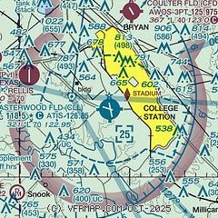
| Sectional chart |
|---|
|
 Download PDF
of official airport diagram from the FAA
| Airport distance calculator |
|---|
|
|
| Sunrise and sunset |
|---|
|
Times for 03-Feb-2026
| | Local
(UTC-6) | | Zulu
(UTC) |
|---|
| Morning civil twilight | | 06:51 | | 12:51 |
| Sunrise | | 07:16 | | 13:16 |
| Sunset | | 18:02 | | 00:02 |
| Evening civil twilight | | 18:27 | | 00:27 |
|
| Current date and time |
|---|
| Zulu (UTC) | 03-Feb-2026 12:37:27 |
|---|
| Local (UTC-6) | 03-Feb-2026 06:37:27 |
|---|
|
| METAR |
|---|
| KCLL | 031208Z AUTO 17005KT 10SM BKN014 BKN019 OVC024 16/15 A3011 RMK AO2 RAE07 P0000 T01560150
|
KCFD
8nm N | 031215Z AUTO 16005KT 10SM SCT007 BKN014 OVC024 16/15 A3013 RMK AO2 T01560147
|
KRWV
18nm W | 031215Z AUTO 19011KT 10SM OVC016 18/15 A3011 RMK AO2 PWINO
|
|
| TAF |
|---|
| KCLL | 031120Z 0312/0412 21011KT P6SM BKN009 OVC020 WS020/20040KT FM031600 22010KT P6SM VCSH BKN015 BKN035 FM032100 24008KT P6SM SCT028 OVC050 PROB30 0322/0324 5SM -TSRA BR SCT028CB FM040000 34006KT P6SM BKN035 OVC050 FM040800 36009KT P6SM FEW080 FEW250
|
|
| NOTAMs |
|---|
NOTAMs are issued by the DoD/FAA and will open in a separate window not controlled by AirNav.
|
|


