FAA INFORMATION EFFECTIVE 16 APRIL 2026
Location
| FAA Identifier: | D09 |
| Lat/Long: | 48-49-49.7000N 100-25-02.3000W
48-49.828333N 100-25.038333W
48.8304722,-100.4173056
(estimated) |
| Elevation: | 1680.1 ft. / 512.1 m (surveyed) |
| Variation: | 08E (2000) |
| From city: | 1 mile E of BOTTINEAU, ND |
| Time zone: | UTC -5 (UTC -6 during Standard Time) |
| Zip code: | 58318 |
Airport Operations
| Airport use: | Open to the public |
| Activation date: | 10/1959 |
| Control tower: | no |
| ARTCC: | MINNEAPOLIS CENTER |
| FSS: | GRAND FORKS FLIGHT SERVICE STATION |
| NOTAMs facility: | GFK (NOTAM-D service available) |
| Attendance: | SAT-SUN ON CALL
FOR ASSTNC CTC AMGR. |
| Wind indicator: | lighted |
| Segmented circle: | yes |
| Lights: | ACTVT MIRL RWY 13/31 & PAPI RWYS 13 & 31 - CTAF |
| Beacon: | white-green (lighted land airport)
Operates sunset to sunrise. |
Airport Communications
| CTAF/UNICOM: | 122.8 |
| WX AWOS-3PT: | 118.25 (701-228-2688) |
| MINOT APPROACH: | 119.6 [0600-2400] |
| MINOT DEPARTURE: | 119.6 [0600-2400] |
- APCH/DEP SVC PRVDD BY MINNEAPOLIS ARTCC ON FREQS 127.6/279.6 (MINOT RCAG) WHEN MINOT APCH CTL CLSD.
Airport Services
| Fuel available: | 100LL
100LL:SELF SVC VIA CREDIT CARD. |
| Parking: | hangars and tiedowns |
| Airframe service: | MAJOR |
| Powerplant service: | MAJOR |
| Bottled oxygen: | NONE |
| Bulk oxygen: | NONE |
Runway Information
Runway 13/31
| Dimensions: | 3700 x 60 ft. / 1128 x 18 m |
| Surface: | asphalt, in good condition |
| Weight bearing capacity: | |
| Runway edge lights: | medium intensity |
| RUNWAY 13 | | RUNWAY 31 |
| Latitude: | 48-50.004818N | | 48-49.573797N |
| Longitude: | 100-25.299965W | | 100-24.649770W |
| Elevation: | 1679.1 ft. | | 1661.4 ft. |
| Traffic pattern: | left | | left |
| Runway heading: | 127 magnetic, 135 true | | 307 magnetic, 315 true |
| Markings: | nonprecision, in good condition | | nonprecision, in good condition |
| Visual slope indicator: | 2-light PAPI on right (3.00 degrees glide path) | | 2-light PAPI on left (3.00 degrees glide path) |
| Runway end identifier lights: | no | | no |
| Touchdown point: | yes, no lights | | yes, no lights |
| Obstructions: | 23 ft. road, 615 ft. from runway, 310 ft. left of centerline, 18:1 slope to clear | | none |
Runway 3/21
| Dimensions: | 2115 x 170 ft. / 645 x 52 m |
| Surface: | turf, in good condition |
| Runway edge markings: | RWYS 03 & 21 MKD WITH BLACK & WHITE CONES. |
| RUNWAY 3 | | RUNWAY 21 |
| Latitude: | 48-49.752952N | | 48-50.036113N |
| Longitude: | 100-25.302797W | | 100-24.996917W |
| Elevation: | 1667.7 ft. | | 1680.1 ft. |
| Traffic pattern: | left | | left |
| Runway heading: | 027 magnetic, 035 true | | 207 magnetic, 215 true |
| Markings: | NSTD | | NSTD |
| Runway end identifier lights: | no | | no |
| Touchdown point: | yes, no lights | | yes, no lights |
| Obstructions: | none | | 25 ft. road, 450 ft. from runway, 170 ft. right of centerline, 18:1 slope to clear
DTHR APCH SLP 20:1. |
Airport Ownership and Management from official FAA records
| Ownership: | Publicly-owned |
| Owner: | BOTTINEAU AIRPORT AUTH
9770 13TH AVE NE
BOTTINEAU, ND 58318
Phone (701) 228-2983
LEO JOSTAD, APT AUTHORITY CHAIRMAN. |
| Manager: | LEO JOSTAD
9770 13TH AVE NE
BOTTINEAU, ND 58318
Phone (701) 228-2983 |
Additional Remarks
| - | CFM WINTER COND BFR USE & AFT MAJOR WINTER STORM WITH AMGR. |
| - | RWY 03/21 CLSD WINTER MONTHS DUE TO LACK OF SNOW REMOVAL. |
| - | BIRDS ON & INVOF ARPT. |
| - | FOR CD CTC MINNEAPOLIS ARTCC AT 651-463-5588. |
Instrument Procedures
NOTE: All procedures below are presented as PDF files. If you need a reader for these files, you should download the free Adobe Reader.NOT FOR NAVIGATION. Please procure official charts for flight.
FAA instrument procedures published for use from 16 April 2026 at 0901Z to 14 May 2026 at 0900Z.
IAPs - Instrument Approach Procedures |
|---|
| RNAV (GPS) RWY 13 | |
download (201KB) |
| RNAV (GPS) RWY 31 | |
download (216KB) |
| NOTE: Special Alternate Minimums apply | |
download (174KB) |
| NOTE: Special Take-Off Minimums/Departure Procedures apply | |
download (156KB) |
Other nearby airports with instrument procedures:
KRUG - Rugby Municipal Airport (31 nm SE)
06D - Rolla Municipal Airport/Leonard Krech Field (32 nm E)
KHBC - Mohall Municipal Airport (44 nm W)
KMIB - Minot Air Force Base (45 nm SW)
KMOT - Minot International Airport (48 nm SW)
|
|

Road maps at:
MapQuest
Bing
Google
| Aerial photo |
|---|
WARNING: Photo may not be current or correct

Do you have a better or more recent aerial photo of Bottineau Municipal Airport that you would like to share? If so, please send us your photo.
|
| Sectional chart |
|---|
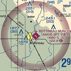
|
| Airport distance calculator |
|---|
|
|
| Sunrise and sunset |
|---|
|
Times for 07-May-2026
| | Local
(UTC-5) | | Zulu
(UTC) |
|---|
| Morning civil twilight | | 05:36 | | 10:36 |
| Sunrise | | 06:12 | | 11:12 |
| Sunset | | 21:04 | | 02:04 |
| Evening civil twilight | | 21:41 | | 02:41 |
|
| Current date and time |
|---|
| Zulu (UTC) | 07-May-2026 20:01:17 |
|---|
| Local (UTC-5) | 07-May-2026 15:01:17 |
|---|
|
| METAR |
|---|
KRUG
31nm SE | 071955Z AUTO 31013G19KT 10SM CLR 14/M08 A2979 RMK AO2
|
K06D
32nm E | 071955Z AUTO 35007G17KT 300V020 10SM CLR 12/M21 A2979 RMK AO2
|
KMIB
44nm SW | 071855Z 30012G17KT 10SM SCT200 14/M10 A2977 RMK AO2A SLP099 T01411099 VISNO RWY30 $
|
KMOT
48nm SW | 071954Z 31009G19KT 10SM CLR 15/M09 A2980 RMK AO2 SLP101 T01501089 $
|
|
| TAF |
|---|
KMIB
44nm SW | 071700Z 0717/0823 31010G20KT 9999 SCT210 QNH2980INS BECMG 0718/0719 31010G20KT 9999 BKN180 QNH2973INS BECMG 0802/0803 VRB06KT 9999 BKN100 QNH2973INS BECMG 0807/0809 29010G20KT 9999 FEW080 QNH2972INS BECMG 0815/0816 30015G25KT 9999 BKN080 620807 QNH2962INS TEMPO 0820/0823 31020G30KT 9000 -RA BKN070 620708 510003 TX15/0723Z TN02/0808Z
|
KMOT
48nm SW | 071727Z 0718/0818 32009KT P6SM FEW200 FM080200 VRB05KT P6SM SCT060 BKN150 FM080900 26008KT P6SM SCT150 FM081400 31012G22KT P6SM SCT060
|
|
| NOTAMs |
|---|
NOTAMs are issued by the DoD/FAA and will open in a separate window not controlled by AirNav.
|
|

