FAA INFORMATION EFFECTIVE 16 APRIL 2026
Location
| FAA Identifier: | E38 |
| Lat/Long: | 30-23-03.2000N 103-41-00.9000W
30-23.053333N 103-41.015000W
30.3842222,-103.6835833
(estimated) |
| Elevation: | 4514.4 ft. / 1376.0 m (surveyed) |
| Variation: | 09E (1990) |
| From city: | 2 miles NW of ALPINE, TX |
| Time zone: | UTC -5 (UTC -6 during Standard Time) |
| Zip code: | 79831 |
Airport Operations
| Airport use: | Open to the public |
| Activation date: | 10/1937 |
| Control tower: | no |
| ARTCC: | ALBUQUERQUE CENTER |
| FSS: | SAN ANGELO FLIGHT SERVICE STATION |
| NOTAMs facility: | E38 (NOTAM-D service available) |
| Attendance: | MON-FRI 0800-1700, ALL SAT 0800-1600
UNATNDD SUN & MAJ HOL. AFT HRS CALL-IN FEE. |
| Wind indicator: | lighted |
| Segmented circle: | yes |
| Lights: | MIRL RWY 01/19 PRESET LOW INTST; TO INCR INTST AND TO ACTVT MIRL RWY 05/23 - CTAF. |
| Beacon: | white-green (lighted land airport)
Operates sunset to sunrise. |
Airport Communications
| CTAF/UNICOM: | 122.8 |
| WX AWOS-3: | 119.025 (432-837-9613) |
| WX AWOS-3PT at MRF (17 nm W): | 134.025 (432-729-3364) |
- APCH/DEP SVC PRVDD BY ALBUQUERQUE ARTCC (ABQ) ON FREQS 135.875/292.15 (FORT STOCKTON RCAG).
Nearby radio navigation aids
| VOR radial/distance | | VOR name | | Freq | | Var |
|---|
| MRFr059/15.0 | | MARFA VOR/DME | | 115.90 | | 11E |
| NDB name | | Hdg/Dist | | Freq | | Var | | ID |
|---|
| MARATHON | | 277/24.2 | | 388 | | 10E | | IMP | .. -- .--. |
Airport Services
| Fuel available: | 100LL JET-A JET-A1+ |
| Airframe service: | MAJOR |
| Powerplant service: | MAJOR |
| Bottled oxygen: | NONE |
| Bulk oxygen: | NONE |
Runway Information
Runway 1/19
| Dimensions: | 6002 x 75 ft. / 1829 x 23 m |
| Surface: | asphalt, in fair condition |
| Weight bearing capacity: | |
| Runway edge lights: | medium intensity |
| RUNWAY 1 | | RUNWAY 19 |
| Latitude: | 30-22.524293N | | 30-23.437672N |
| Longitude: | 103-41.204260W | | 103-40.764150W |
| Elevation: | 4514.3 ft. | | 4449.5 ft. |
| Traffic pattern: | left | | left |
| Runway heading: | 014 magnetic, 023 true | | 194 magnetic, 203 true |
| Markings: | nonprecision, in fair condition | | nonprecision, in fair condition |
| Visual slope indicator: | 2-light PAPI on left (3.50 degrees glide path)
PAPI RWY 01 DOES NOT PRVD OBSTN CLNC BYD 2.0 NM FM THR. | | 2-light PAPI on left (3.00 degrees glide path) |
| Touchdown point: | yes, no lights | | yes, no lights |
| Obstructions: | 30 ft. pline, 1340 ft. from runway, 38:1 slope to clear | | 4 ft. fence, 295 ft. from runway, 23:1 slope to clear |
Runway 5/23
| Dimensions: | 5018 x 60 ft. / 1529 x 18 m |
| Surface: | asphalt, in good condition |
| Weight bearing capacity: | |
| Runway edge lights: | medium intensity |
| RUNWAY 5 | | RUNWAY 23 |
| Latitude: | 30-22.942300N | | 30-23.334535N |
| Longitude: | 103-41.473237W | | 103-40.632777W |
| Elevation: | 4509.6 ft. | | 4447.8 ft. |
| Traffic pattern: | left | | left |
| Runway heading: | 053 magnetic, 062 true | | 233 magnetic, 242 true |
| Markings: | nonprecision, in good condition | | nonprecision, in good condition |
| Touchdown point: | yes, no lights | | yes, no lights |
| Obstructions: | 10 ft. fence, 500 ft. from runway, 30:1 slope to clear | | 15 ft. road, 537 ft. from runway, 22:1 slope to clear |
Airport Ownership and Management from official FAA records
| Ownership: | Publicly-owned |
| Owner: | CITY OF ALPINE
100 N. 13TH STREET
ALPINE, TX 79830
Phone 432-837-3301 |
| Manager: | MEGAN ANTRIM
100 N. 13TH STREET
ALPINE, TX 79830
Phone 432-837-5929
CITY/AMGR. |
Additional Remarks
| - | FOR CD CTC ALBUQUERQUE ARTCC AT 505-856-4861. |
| - | SELF SVC FUEL AVBL 24 HRS. |
Instrument Procedures
NOTE: All procedures below are presented as PDF files. If you need a reader for these files, you should download the free Adobe Reader.NOT FOR NAVIGATION. Please procure official charts for flight.
FAA instrument procedures published for use from 16 April 2026 at 0901Z to 14 May 2026 at 0900Z.
IAPs - Instrument Approach Procedures |
|---|
| RNAV (GPS) RWY 19 | |
download (220KB) |
| RNAV (GPS) RWY 23 | |
download (224KB) |
| NOTE: Special Alternate Minimums apply | |
download (50KB) |
|
|---|
| ODKAE ONE (OBSTACLE) | |
2 pages:
[1] [2] (476KB) |
| NOTE: Special Take-Off Minimums/Departure Procedures apply | |
download (292KB) |
Other nearby airports with instrument procedures:
KMRF - Marfa Municipal Airport (17 nm W)
KFST - Fort Stockton-Pecos County Airport (51 nm NE)
KPRS - Presidio Lely International Airport (57 nm SW)
KPEQ - Pecos Municipal Airport (61 nm N)
T89 - Lajitas International Airport (66 nm S)
|
|

Road maps at:
MapQuest
Bing
Google
| Aerial photo |
|---|
WARNING: Photo may not be current or correct
 Photo by P. J. Reinders
Photo taken 11-Feb-2009
on final runway 01
Photo by P. J. Reinders
Photo taken 11-Feb-2009
on final runway 01
Do you have a better or more recent aerial photo of Alpine-Casparis Municipal Airport that you would like to share? If so, please send us your photo.
|
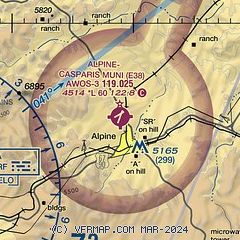
| Sectional chart |
|---|
|
| Airport distance calculator |
|---|
|
|
| Sunrise and sunset |
|---|
|
Times for 08-May-2026
| | Local
(UTC-5) | | Zulu
(UTC) |
|---|
| Morning civil twilight | | 06:41 | | 11:41 |
| Sunrise | | 07:06 | | 12:06 |
| Sunset | | 20:36 | | 01:36 |
| Evening civil twilight | | 21:02 | | 02:02 |
|
| Current date and time |
|---|
| Zulu (UTC) | 08-May-2026 20:44:03 |
|---|
| Local (UTC-5) | 08-May-2026 15:44:03 |
|---|
|
| METAR |
|---|
| KE38 | 082015Z AUTO 34015KT 10SM SCT065 SCT070 BKN095 23/08 A2996 RMK AO2 LTG DSNT NE AND NW T02340079
|
KMRF
17nm W | 082027Z AUTO 33015G21KT 10SM VCTS SCT095 BKN120 22/05 A2998 RMK AO2 LTG DSNT N PRESRR SLP100 P0000 T02170050 $
|
|
| NOTAMs |
|---|
NOTAMs are issued by the DoD/FAA and will open in a separate window not controlled by AirNav.
|
|


