FAA INFORMATION EFFECTIVE 27 NOVEMBER 2025
Location
| FAA Identifier: | EGE |
| Lat/Long: | 39-38-33.9000N 106-54-57.4000W
39-38.565000N 106-54.956667W
39.6427500,-106.9159444
(estimated) |
| Elevation: | 6547.4 ft. / 1995.6 m (surveyed) |
| Variation: | 09E (2020) |
| From city: | 4 miles W of EAGLE, CO |
| Time zone: | UTC -7 (UTC -6 during Daylight Saving Time) |
| Zip code: | 81637 |
Airport Operations
| Airport use: | Open to the public |
| Activation date: | 07/1940 |
| Control tower: | yes |
| ARTCC: | DENVER CENTER |
| FSS: | DENVER FLIGHT SERVICE STATION |
| NOTAMs facility: | EGE (NOTAM-D service available) |
| Attendance: | APR-NOV 0700-1900, DEC-MAR 0700-2300 |
| Wind indicator: | lighted |
| Segmented circle: | yes |
| Lights: | WHEN ATCT CLSD ACTVT MALSR RWY 25; REIL RWY 07; HIRL RWY 07/25 - CTAF. PAPI RWY 25 OPR CONSLY. |
| Beacon: | white-green (lighted land airport)
Operates sunset to sunrise. |
| Landing fee: | yes, LNDG FEE OF $3.00 PER THOUSAND POUNDS FOR GA ACFT 12,500 LBS. |
| Fire and rescue: | ARFF index C |
| Airline operations: | UNSKED ACR OPNS WITH MORE THAN 30 PSGR SEATS CALL ARPT FIRE DEPT 970-328-2688. |
| International operations: | REGULAR OFFICE HOURS: THU-MON 0900-1700. AFTER HRS SVC
AVBL: OFFICE 970-524-0490. AFTER HRS 303-472-1125.
THREE HR ADVANCE NOTICE REQUIRED. |
Airport Communications
| CTAF: | 119.8 |
| ATIS: | 135.575 |
| WX AWOS-3PT: | 135.575 (970-524-7386) |
| EAGLE GROUND: | 121.8 [0700-1900 HRS.] |
| EAGLE TOWER: | 119.8 [0700-1900 HRS.] |
| CLEARANCE DELIVERY: | 124.75 |
| OPS: | 41.75 ;EAGLES NEST |
- COMMUNICATIONS PRVDD BY DENVER RADIO ON FREQ 122.2 (EAGLE RCO).
- APCH/DEP CTL SVC PRVDD BY DENVER ARTCC (ZDV) ON FREQS 128.65/282.2 (KREMMLING RCAG).
- CLEARANCE DELIVERY PRVDD BY DENVER ARTCC ON FREQ 124.75 WHEN ATCT CLSD.
Nearby radio navigation aids
| VOR radial/distance | | VOR name | | Freq | | Var |
|---|
| SXWr065/3.6 | | SNOW VOR/DME | | 109.20 | | 12E |
| DBLr343/12.2 | | RED TABLE VOR/DME | | 113.00 | | 12E |
| RLGr211/30.7 | | KREMMLING VOR/DME | | 113.80 | | 14E |
| RILr070/37.8 | | RIFLE VOR/DME | | 113.35 | | 10E |
Airport Services
| Fuel available: | 100LL JET-A1 JET-A1+ MOGAS |
| Parking: | hangars and tiedowns |
| Airframe service: | MAJOR |
| Powerplant service: | MAJOR |
| Bottled oxygen: | HIGH |
| Bulk oxygen: | HIGH |
Runway Information
Runway 7/25
| Dimensions: | 9000 x 150 ft. / 2743 x 46 m |
| Surface: | asphalt/grooved, in excellent condition |
| Weight bearing capacity: | | Single wheel: | 75.0, 2S 175 | | Double wheel: | 140.0 | | Double tandem: | 255.0 |
|
| Runway edge lights: | high intensity |
| RUNWAY 7 | | RUNWAY 25 |
| Latitude: | 39-38.461668N | | 39-38.669667N |
| Longitude: | 106-55.905333W | | 106-54.007373W |
| Elevation: | 6460.9 ft. | | 6547.4 ft. |
| Traffic pattern: | right | | left |
| Runway heading: | 073 magnetic, 082 true | | 253 magnetic, 262 true |
| Displaced threshold: | no | | 1000 ft. |
| Declared distances: | TORA:9000 TODA:9000 ASDA:9000 LDA:9000 | | TORA:9000 TODA:9000 ASDA:9000 LDA:8000 |
| Markings: | nonprecision, in good condition | | precision, in good condition |
| Visual slope indicator: | | | 4-light PAPI on right (3.00 degrees glide path) |
| Approach lights: | | | MALSR: 1,400 foot medium intensity approach lighting system with runway alignment indicator lights |
| Runway end identifier lights: | yes | | |
| Touchdown point: | yes, no lights | | yes, no lights |
| Instrument approach: | | | ILS/DME |
| Obstructions: | 503 ft. tree, 10000 ft. from runway, 825 ft. left of centerline, 19:1 slope to clear | | none |
Airport Ownership and Management from official FAA records
| Ownership: | Publicly-owned |
| Owner: | EAGLE COUNTY
BOX 850
EAGLE, CO 81631
Phone 970-328-2680 |
| Manager: | DAVID REID
219 ELDON WILSON ROAD
GYPSUM, CO 81637
Phone (970) 328-2680 |
Additional Remarks
| A30-25X | THIS RWY EXISTS TO SUPPORT (VAZ) LDA/DME ASSOCIATED WITH RWY 25. |
| A39-07/25 | PCR VALUE: 464/F/B/X/T |
| - | NO SNOW REMOVAL OR RWY MONITORING NOV-APR 0600-1300Z. |
| - | ACRS SHOULD NOT LVE OR ENTER TWY A FM RAMP EAST OF TWY C-2. |
| - | CRITICAL ACFT ARE CAT D IV, B757-200 EQUIVALENT AND LOWER. |
| - | FOR ATCT HRS CONTACT ARFF AT 970-328-2688. |
| - | COLD TEMPERATURE AIRPORT. ALTITUDE CORRECTION REQUIRED AT OR BELOW -19C. |
| - | FOR CD CTC EAGLE ATCT AT 970-524-0803, WHEN ATCT CLSD CTC DENVER ARTCC AT 303-651-4257. |
| - | EXTENSIVE MILITARY HELICOPTER TRAINING OPERATIONS SURFACE TO 1000 FT AGL WITHIN 25 NM RADIUS EAGLE COUNTY AIRPORT 0630-2200. |
| - | HI UNMKD TERRAIN ALL QUADS. NGT OPNS DISCOURAGED TO PILOTS UNFAM WITH ARPT. |
| - | RECOMMEND ALL ACFT DEPT RWY 25 INITIATE A LEFT TURN AS SOON AS ALTITUDE & SAFETY PERMIT TO AVOID HIGH TERRAIN. |
| - | MTN TOP 10:1 CLNC 13000 FT FM THR, 1500 FT LEFT OF RWY CNTRLN EXTENDED. |
Instrument Procedures
NOTE: All procedures below are presented as PDF files. If you need a reader for these files, you should download the free Adobe Reader.NOT FOR NAVIGATION. Please procure official charts for flight.
FAA instrument procedures published for use from 27 November 2025 at 0901Z to 25 December 2025 at 0900Z.
STARs - Standard Terminal Arrivals |
|---|
| AAVON ONE (RNAV) | |
download (239KB) |
| VAAIL ONE (RNAV) | |
download (176KB) |
IAPs - Instrument Approach Procedures |
|---|
| RNAV (RNP) X RWY 25 | |
download (434KB) |
| RNAV (RNP) Z RWY 25 | |
download (436KB) |
| RNAV (GPS) Y RWY 25 | |
download (453KB) |
| RNAV (GPS)-D | |
download (462KB) |
| LDA RWY 25 | |
download (473KB) |
| NOTE: Special Alternate Minimums apply | |
download (144KB) |
Departure Procedures |
|---|
| BEVVR ONE (RNAV) | |
download (228KB) |
| GYPSUM SIX | |
download (181KB) |
| MEEKER FOUR | |
download (131KB) |
| NOTE: Special Take-Off Minimums/Departure Procedures apply | |
download (298KB) |
Other nearby airports with instrument procedures:
KASE - Aspen-Pitkin County Airport/Sardy Field (25 nm S)
20V - Mc Elroy Airfield (35 nm NE)
KLXV - Lake County Airport (38 nm SE)
KRIL - Rifle Garfield County Airport (38 nm W)
KEEO - Meeker Coulter Field Airport (51 nm NW)
|
|

Road maps at:
MapQuest
Bing
Google
| Aerial photo |
|---|
WARNING: Photo may not be current or correct
 Photo by Jeff Kaplan and Matt Beyer
Photo taken 25-Jul-2015
looking south.
Photo by Jeff Kaplan and Matt Beyer
Photo taken 25-Jul-2015
looking south.
Do you have a better or more recent aerial photo of Eagle County Regional Airport that you would like to share? If so, please send us your photo.
|
| Sectional chart |
|---|
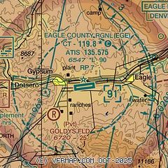
|
 Download PDF
of official airport diagram from the FAA
| Airport distance calculator |
|---|
|
|
| Sunrise and sunset |
|---|
|
Times for 15-Dec-2025
| | Local
(UTC-7) | | Zulu
(UTC) |
|---|
| Morning civil twilight | | 06:52 | | 13:52 |
| Sunrise | | 07:22 | | 14:22 |
| Sunset | | 16:43 | | 23:43 |
| Evening civil twilight | | 17:14 | | 00:14 |
|
| Current date and time |
|---|
| Zulu (UTC) | 15-Dec-2025 20:39:14 |
|---|
| Local (UTC-7) | 15-Dec-2025 13:39:14 |
|---|
|
| METAR |
|---|
| KEGE | 151956Z 00000KT 10SM CLR 04/M08 A3036 RMK AO2 SLP300 T00391083 $
|
|
| TAF |
|---|
| KEGE | 151726Z 1518/1618 VRB04KT P6SM SCT250
|
|
| NOTAMs |
|---|
NOTAMs are issued by the DoD/FAA and will open in a separate window not controlled by AirNav.
|
|


