FAA INFORMATION EFFECTIVE 19 MARCH 2026
Location
| FAA Identifier: | FAM |
| Lat/Long: | 37-45-39.2120N 090-25-43.2050W
37-45.653533N 090-25.720083W
37.7608922,-90.4286681
(estimated) |
| Elevation: | 945.7 ft. / 288.2 m (surveyed) |
| Variation: | 02W (2025) |
| From city: | 1 mile S of FARMINGTON, MO |
| Time zone: | UTC -5 (UTC -6 during Standard Time) |
| Zip code: | 63640 |
Airport Operations
| Airport use: | Open to the public |
| Activation date: | 02/1962 |
| Control tower: | no |
| ARTCC: | KANSAS CITY CENTER |
| FSS: | SAINT LOUIS FLIGHT SERVICE STATION |
| NOTAMs facility: | FAM (NOTAM-D service available) |
| Attendance: | 0730-1700 |
| Wind indicator: | lighted |
| Segmented circle: | yes |
| Lights: | ACTVT REIL RWY 02 & 20; MIRL RWY 02/20 - CTAF. PAPI RWY 02 OPR CONSLY. |
| Beacon: | white-green (lighted land airport)
Operates sunset to sunrise. |
Airport Communications
| CTAF/UNICOM: | 122.8 |
| WX AWOS-3PT: | 119.275 (573-756-6042) |
- APCH/DEP SVC PRVDD BY KANSAS CITY ARTCC (ZKC) ON FREQS 127.475/346.275 (FARMINGTON RCAG).
Nearby radio navigation aids
| VOR radial/distance | | VOR name | | Freq | | Var |
|---|
| FAMr299/10.6 | | FARMINGTON VORTAC | | 115.70 | | 01E |
Airport Services
| Fuel available: | 100LL JET-A |
| Parking: | tiedowns |
| Airframe service: | MAJOR |
| Powerplant service: | MAJOR |
| Bottled oxygen: | NONE |
| Bulk oxygen: | NONE |
Runway Information
Runway 2/20
| Dimensions: | 4323 x 75 ft. / 1318 x 23 m
100 FT X 75 FT FULL STRENGTH CONC SAFETY AREA SOUTHWEST END; 590 FT BY 60 FT ASPH SAFETY AREA NORTHEAST END, NOT FULL STRENGTH. |
| Surface: | concrete, in good condition |
| Weight bearing capacity: | | Single wheel: | 30.0, FOR RWY ONLY; CONTACT AMGR FOR TWY STRENGTH. |
|
| Runway edge lights: | medium intensity |
| RUNWAY 2 | | RUNWAY 20 |
| Latitude: | 37-45.327675N | | 37-45.979372N |
| Longitude: | 090-25.900910W | | 090-25.539215W |
| Elevation: | 907.1 ft. | | 945.7 ft. |
| Traffic pattern: | right | | left |
| Runway heading: | 026 magnetic, 024 true | | 206 magnetic, 204 true |
| Markings: | nonprecision, in good condition | | nonprecision, in good condition |
| Visual slope indicator: | 4-light PAPI on left (3.00 degrees glide path) | | 4-light PAPI on left (3.00 degrees glide path) |
| Runway end identifier lights: | yes | | yes |
| Touchdown point: | yes, no lights | | yes, no lights |
| Obstructions: | 39 ft. trees, 1368 ft. from runway, 150 ft. right of centerline, 29:1 slope to clear
RWY 02 APCH SLOPE 40:1 TO DSPLCD THR. | | none |
Airport Ownership and Management from official FAA records
| Ownership: | Publicly-owned |
| Owner: | CITY OF FARMINGTON
110 W. COLUMBIA ST., LONG MEMORIAL BLDG.
FARMINGTON, MO 63640
Phone (314) 756-1701 |
| Manager: | BRIAN HINSON
110 W. COLUMBIA STREET, LONG MEMORIAL BUILDING
FARMINGTON, MO 63640
Phone 573-756-4502
EXT. 1601 |
Additional Remarks
| - | HEL ACTIVITY ON & INVOF AIRFIELD. |
| - | FOR CD IF UNA TO CTC ON FSS FREQ, CTC KANSAS CITY ARTCC AT 913-254-8508. |
| - | (OVERRUN LEN, RWY 02) 560 FT UNUSBL. |
Instrument Procedures
NOTE: All procedures below are presented as PDF files. If you need a reader for these files, you should download the free Adobe Reader.NOT FOR NAVIGATION. Please procure official charts for flight.
FAA instrument procedures published for use from 19 March 2026 at 0901Z to 16 April 2026 at 0900Z.
IAPs - Instrument Approach Procedures |
|---|
| RNAV (GPS) RWY 02 | |
download (250KB) |
| RNAV (GPS) RWY 20 | |
download (201KB) |
| VOR/DME-A | |
download (171KB) |
| NOTE: Special Alternate Minimums apply | |
download (40KB) |
| NOTE: Special Take-Off Minimums/Departure Procedures apply | |
download (429KB) |
Other nearby airports with instrument procedures:
H88 - A Paul Vance Fredericktown Regional Airport (11 nm SE)
8WC - Washington County Airport (18 nm NW)
KPCD - Perryville Regional Airport (28 nm E)
KSAR - Sparta Community Airport-Hunter Field (42 nm NE)
KUUV - Sullivan Regional Airport (45 nm NW)
|
|

Road maps at:
MapQuest
Bing
Google
| Aerial photo |
|---|
WARNING: Photo may not be current or correct
 Taken in May 2010
Do you have a better or more recent aerial photo of Farmington Regional Airport that you would like to share? If so, please send us your photo.
|
| Sectional chart |
|---|
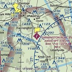
|
| Airport distance calculator |
|---|
|
|
| Sunrise and sunset |
|---|
|
Times for 23-Mar-2026
| | Local
(UTC-5) | | Zulu
(UTC) |
|---|
| Morning civil twilight | | 06:35 | | 11:35 |
| Sunrise | | 07:02 | | 12:02 |
| Sunset | | 19:15 | | 00:15 |
| Evening civil twilight | | 19:41 | | 00:41 |
|
| Current date and time |
|---|
| Zulu (UTC) | 24-Mar-2026 00:28:02 |
|---|
| Local (UTC-5) | 23-Mar-2026 19:28:02 |
|---|
|
| METAR |
|---|
| KFAM | 232356Z AUTO 08005KT 10SM CLR 09/M02 A3036 RMK AO2 SLP295 T00891017 10128 20089 53000 $
|
|
| NOTAMs |
|---|
NOTAMs are issued by the DoD/FAA and will open in a separate window not controlled by AirNav.
|
|

