FAA INFORMATION EFFECTIVE 14 MAY 2026
Location
| FAA Identifier: | UUV |
| Lat/Long: | 38-14-00.5000N 091-09-51.4000W
38-14.008333N 091-09.856667W
38.2334722,-91.1642778
(estimated) |
| Elevation: | 933 ft. / 284.4 m (surveyed) |
| Variation: | 02E (1995) |
| From city: | 1 mile N of SULLIVAN, MO |
| Time zone: | UTC -5 (UTC -6 during Standard Time) |
| Zip code: | 63080 |
Airport Operations
| Airport use: | Open to the public |
| Activation date: | 04/1991 |
| Control tower: | no |
| ARTCC: | KANSAS CITY CENTER |
| FSS: | SAINT LOUIS FLIGHT SERVICE STATION |
| NOTAMs facility: | STL (NOTAM-D service available) |
| Attendance: | 0700-1600
AFT HRS CALL 573-468-8001 (POLICE DEPT.) |
| Wind indicator: | lighted |
| Segmented circle: | yes |
| Lights: | DUSK-DAWN. MIRL RY 06/24 PRESET ON LOW INTST; TO INCR INTST ACTVT - CTAF. PAPI ON 24 HRS. |
| Beacon: | white-green (lighted land airport)
Operates sunset to sunrise. |
Airport Communications
| CTAF/UNICOM: | 122.7 |
| WX AWOS-3PT: | 119.375 (573-860-2596) |
- APCH/DEP SVC PRVDD BY KANSAS CITY ARTCC ON FREQS 128.35/284.675 (MAPLES RCAG).
Nearby radio navigation aids
| VOR radial/distance | | VOR name | | Freq | | Var |
|---|
| VIHr073/26.0 | | VICHY VOR/DME | | 117.70 | | 06E |
| FTZr193/29.1 | | FORISTELL VORTAC | | 114.35 | | 05E |
Airport Services
| Fuel available: | 100LL JET-A |
| Parking: | tiedowns |
| Airframe service: | NONE |
| Powerplant service: | NONE |
Runway Information
Runway 6/24
| Dimensions: | 4500 x 75 ft. / 1372 x 23 m |
| Surface: | concrete, in good condition |
| Weight bearing capacity: | |
| Runway edge lights: | medium intensity |
| Operational restrictions: | RESTRICTED TO ACFT 12,500 LBS MAX GWT OR LESS; PPR FOR ACFT EXCEEDING 12,500 LBS CALL AMGR. |
| RUNWAY 6 | | RUNWAY 24 |
| Latitude: | 38-13.824760N | | 38-14.192895N |
| Longitude: | 091-10.265012W | | 091-09.449173W |
| Elevation: | 933.0 ft. | | 924.0 ft. |
| Traffic pattern: | left | | right |
| Runway heading: | 058 magnetic, 060 true | | 238 magnetic, 240 true |
| Markings: | nonprecision, in good condition | | nonprecision, in good condition |
| Visual slope indicator: | 2-light PAPI on left (4.00 degrees glide path) | | 2-light PAPI on left (3.00 degrees glide path) |
| Touchdown point: | yes, no lights | | yes, no lights |
| Obstructions: | 44 ft. trees, 810 ft. from runway, 110 ft. right of centerline, 13:1 slope to clear | | none |
Airport Ownership and Management from official FAA records
| Ownership: | Publicly-owned |
| Owner: | CITY OF SULLIVAN
210 W. WASHINGTON ST
SULLIVAN, MO 63080
Phone 573-468-4612 |
| Manager: | DEAN BLANKENSHIP
345 N. CHURCH ST
SULLIVAN, MO 63080
Phone (573) 468-4912 |
Additional Remarks
| - | DEER, COYOTES, WATERFOWL ON & INVOF ARPT. |
| - | FOR CD CTC KANSAS CITY ARTCC AT 913-254-8508. |
Instrument Procedures
NOTE: All procedures below are presented as PDF files. If you need a reader for these files, you should download the free Adobe Reader.NOT FOR NAVIGATION. Please procure official charts for flight.
FAA instrument procedures published for use from 14 May 2026 at 0901Z to 11 June 2026 at 0900Z.
IAPs - Instrument Approach Procedures |
|---|
| RNAV (GPS) RWY 06 | |
download (235KB) |
| RNAV (GPS) RWY 24 | |
download (236KB) |
| NOTE: Special Take-Off Minimums/Departure Procedures apply | |
download (437KB) |
Other nearby airports with instrument procedures:
KUBX - Cuba Municipal Airport (16 nm SW)
KFYG - Washington Regional Airport (23 nm N)
8WC - Washington County Airport (27 nm SE)
KVIH - Rolla National Airport (29 nm W)
KSUS - Spirit of St Louis Airport (35 nm NE)
|
|

Road maps at:
MapQuest
Bing
Google
| Aerial photo |
|---|
WARNING: Photo may not be current or correct
 Photo taken 18-Jul-2015
looking north.
Photo taken 18-Jul-2015
looking north.
Do you have a better or more recent aerial photo of Sullivan Regional Airport that you would like to share? If so, please send us your photo.
|
| Sectional chart |
|---|
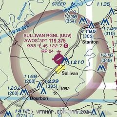
|
| Airport distance calculator |
|---|
|
|
| Sunrise and sunset |
|---|
|
Times for 26-May-2026
| | Local
(UTC-5) | | Zulu
(UTC) |
|---|
| Morning civil twilight | | 05:16 | | 10:16 |
| Sunrise | | 05:47 | | 10:47 |
| Sunset | | 20:17 | | 01:17 |
| Evening civil twilight | | 20:47 | | 01:47 |
|
| Current date and time |
|---|
| Zulu (UTC) | 26-May-2026 23:49:40 |
|---|
| Local (UTC-5) | 26-May-2026 18:49:40 |
|---|
|
| METAR |
|---|
| KUUV | 262335Z AUTO 00000KT 10SM CLR CLR A2996 RMK AO2
|
|
| TAF |
|---|
KSUS
35nm NE | 262045Z 2621/2718 08007KT P6SM VCTS SCT050CB BKN150 FM262300 08006KT P6SM SCT050 BKN150 FM271000 VRB03KT P6SM BKN020 OVC050 FM271700 VRB04KT P6SM BKN050
|
|
| NOTAMs |
|---|
NOTAMs are issued by the DoD/FAA and will open in a separate window not controlled by AirNav.
|
|

