FAA INFORMATION EFFECTIVE 22 JANUARY 2026
Location
| FAA Identifier: | FLX |
| Lat/Long: | 39-29-57.0100N 118-44-55.6520W
39-29.950167N 118-44.927533W
39.4991694,-118.7487922
(estimated) |
| Elevation: | 3966.4 ft. / 1209.0 m (surveyed) |
| Variation: | 14E (2010) |
| From city: | 2 miles NE of FALLON, NV |
| Time zone: | UTC -8 (UTC -7 during Daylight Saving Time) |
| Zip code: | 89406 |
Airport Operations
| Airport use: | Open to the public |
| Activation date: | 08/1952 |
| Control tower: | no |
| ARTCC: | OAKLAND CENTER |
| FSS: | RENO FLIGHT SERVICE STATION |
| NOTAMs facility: | RNO (NOTAM-D service available) |
| Attendance: | 0800-1700 |
| Pattern altitude: | 4766.4 ft. MSL |
| Wind indicator: | yes |
| Segmented circle: | yes |
| Lights: | SS-SR |
| Beacon: | white-green (lighted land airport)
Operates sunset to sunrise. |
Airport Communications
| CTAF/UNICOM: | 122.8 |
| WX AWOS-AV: | 118.25 (775-423-2201) |
| NAVY FALLON APPROACH: | 120.85 [SAME AS TWR HRS] |
| NAVY FALLON DEPARTURE: | 120.85 [SAME AS TWR HRS] |
- APCH/DEP CTL SVC PRVDD BY OAKLAND ARTCC (ZOA) ON FREQ 128.8/285.5 (FALLON RCAG), WHEN NAVY FALLON APCH CTL (NFL) CLSD.
- COMMUNICATIONS PRVDD BY RENO RADIO ON FREQS 122.1R/114.1T (HAZEN RCO).
Nearby radio navigation aids
| VOR radial/distance | | VOR name | | Freq | | Var |
|---|
| HZNr078/11.6 | | HAZEN VORTAC | | 114.10 | | 17E |
| LLCr176/38.4 | | LOVELOCK VORTAC | | 116.50 | | 16E |
Airport Services
| Fuel available: | 100LL JET-A |
| Parking: | hangars and tiedowns |
| Airframe service: | MAJOR |
| Powerplant service: | MAJOR |
| Bottled oxygen: | LOW |
| Bulk oxygen: | NONE |
Runway Information
Runway 3/21
| Dimensions: | 5705 x 75 ft. / 1739 x 23 m |
| Surface: | asphalt, in good condition |
| Weight bearing capacity: | |
| Runway edge lights: | medium intensity |
| RUNWAY 3 | | RUNWAY 21 |
| Latitude: | 39-29.661250N | | 39-30.284083N |
| Longitude: | 118-45.394982W | | 118-44.487088W |
| Elevation: | 3966.3 ft. | | 3962.9 ft. |
| Traffic pattern: | left | | left |
| Runway heading: | 034 magnetic, 048 true | | 214 magnetic, 228 true |
| Displaced threshold: | 102 ft. | | no |
| Declared distances: | TORA:5703 TODA:5703 | | TORA:5703 TODA:5703 |
| Markings: | nonprecision, in good condition | | nonprecision, in good condition |
| Visual slope indicator: | 2-light PAPI on left (3.00 degrees glide path) | | 2-light PAPI on left (3.00 degrees glide path) |
| Runway end identifier lights: | no | | no |
| Touchdown point: | yes, no lights | | yes, no lights |
| Obstructions: | 14 ft. road, 475 ft. from runway, 19:1 slope to clear | | 88 ft. trees, 1900 ft. from runway, 100 ft. right of centerline, 19:1 slope to clear |
Runway 13/31
| Dimensions: | 3581 x 60 ft. / 1091 x 18 m |
| Surface: | dirt, in excellent condition |
| RUNWAY 13 | | RUNWAY 31 |
| Latitude: | 39-30.157650N | | 39-29.670903N |
| Longitude: | 118-45.120900W | | 118-44.691038W |
| Elevation: | 3962.0 ft. | | 3961.4 ft. |
| Traffic pattern: | left | | left |
| Runway heading: | 132 magnetic, 146 true | | 312 magnetic, 326 true |
| Runway end identifier lights: | no | | no |
| Touchdown point: | yes, no lights | | yes, no lights |
| Obstructions: | 29 ft. trees, 490 ft. from runway, 16:1 slope to clear
TREES ON CARSON RIVER. | | 10 ft. road, 250 ft. from runway, 25:1 slope to clear |
Airport Ownership and Management from official FAA records
| Ownership: | Publicly-owned |
| Owner: | CITY OF FALLON
55 WEST WILLIAMS AVE
FALLON, NV 89406
Phone 775-423-5107 |
| Manager: | DEREK ZIMNEY
55 WEST WILLIAMS AVE
FALLON, NV 89406
Phone 775-213-3457
BRIAN BYRD |
Additional Remarks
| A39-03/21 | PCR VALUE: 82/F/C/X/T |
| - | OVHD JET & ULTRALIGHT ACT INVOF ARPT. |
| - | FOR CD CTC OAKLAND ARTCC AT 510-745-3380. |
| - | LINE OF SIGHT BTN RWY 03 & 13 END BLOCKED; TMT ALL ARR & DEP. |
| - | (CONTACT PHONE NR) 775-426-9996 |
Instrument Procedures
NOTE: All procedures below are presented as PDF files. If you need a reader for these files, you should download the free Adobe Reader.NOT FOR NAVIGATION. Please procure official charts for flight.
FAA instrument procedures published for use from 22 January 2026 at 0901Z to 19 February 2026 at 0900z.
IAPs - Instrument Approach Procedures |
|---|
| RNAV (GPS)-C | |
download (171KB) |
| VOR-B | |
download (180KB) |
| NOTE: Special Take-Off Minimums/Departure Procedures apply | |
download (272KB) |
Other nearby airports with instrument procedures:
KNFL - Fallon Naval Air Station (Van Voorhis Field) Airport (5 nm SE)
KSPZ - Silver Springs Airport (24 nm W)
KLOL - Derby Field Airport (35 nm N)
O43 - Yerington Municipal Airport (35 nm SW)
KRNO - Reno/Tahoe International Airport (47 nm W)
|
|

Road maps at:
MapQuest
Bing
Google
| Aerial photo |
|---|
WARNING: Photo may not be current or correct
 Photo taken 25-Sep-2011
after a complete runway reconstruction completed January 2011. Looking northeast.
Photo taken 25-Sep-2011
after a complete runway reconstruction completed January 2011. Looking northeast.
Do you have a better or more recent aerial photo of Fallon Municipal Airport that you would like to share? If so, please send us your photo.
|
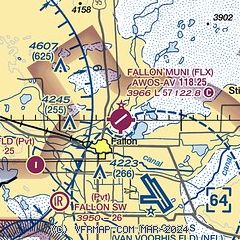
| Sectional chart |
|---|
|
| Airport distance calculator |
|---|
|
|
| Sunrise and sunset |
|---|
|
Times for 04-Feb-2026
| | Local
(UTC-8) | | Zulu
(UTC) |
|---|
| Morning civil twilight | | 06:32 | | 14:32 |
| Sunrise | | 07:01 | | 15:01 |
| Sunset | | 17:17 | | 01:17 |
| Evening civil twilight | | 17:46 | | 01:46 |
|
| Current date and time |
|---|
| Zulu (UTC) | 04-Feb-2026 13:03:49 |
|---|
| Local (UTC-8) | 04-Feb-2026 05:03:49 |
|---|
|
| METAR |
|---|
KNFL
5nm SE | 041157Z AUTO 16005KT 10SM CLR M04/M08 A3050 RMK AO2 SLP279 T10441083 10000 21056 58003
|
|
| TAF |
|---|
KNFL
5nm SE | 0407/0507 VRB05KT 9999 SCT250 QNH3044INS FM041800 VRB06KT 9999 SKC QNH3037INS TEMPO 0420/0501 02006KT AUTOMATED SENSOR METWATCH 0407 TIL 0414 TX14/0423Z TNM06/0414Z FS30227
|
|
| NOTAMs |
|---|
NOTAMs are issued by the DoD/FAA and will open in a separate window not controlled by AirNav.
|
|

