FAA INFORMATION EFFECTIVE 11 JUNE 2026
Location
| FAA Identifier: | FSU |
| Lat/Long: | 34-29-19.5047N 104-12-59.1064W
34-29.325078N 104-12.985107W
34.4887513,-104.2164184
(estimated) |
| Elevation: | 4164.7 ft. / 1269 m (estimated) |
| Variation: | 10E (1985) |
| From city: | 2 miles NE of FORT SUMNER, NM |
| Time zone: | UTC -6 (UTC -7 during Standard Time) |
| Zip code: | 88119 |
Airport Operations
| Airport use: | Open to the public |
| Activation date: | 02/1941 |
| Control tower: | no |
| ARTCC: | ALBUQUERQUE CENTER |
| FSS: | ALBUQUERQUE FLIGHT SERVICE STATION |
| NOTAMs facility: | ABQ (NOTAM-D service available) |
| Attendance: | MON-FRI 0700-1600
AFT HR - 575-355-2405. |
| Wind indicator: | lighted |
| Segmented circle: | yes |
| Lights: | DUSK-DAWN: ACTVT MIRL RWY 08/26 - CTAF. MIRL RWY 03/21 PRESET LOW INTST TILL 2200; AFT 2200 ACTVT - CTAF. |
| Beacon: | white-green (lighted land airport)
Operates sunset to sunrise. |
Airport Communications
Airport Services
Runway Information
Runway 3/21
| Dimensions: | 5800 x 75 ft. / 1768 x 23 m |
| Surface: | asphalt, in fair condition |
| Weight bearing capacity: | | PCN 3 /F/C/Y/T | | Single wheel: | 25.0 |
|
| Runway edge lights: | medium intensity |
| RUNWAY 3 | | RUNWAY 21 |
| Latitude: | 34-29.026000N | | 34-29.700333N |
| Longitude: | 104-13.359333W | | 104-12.540167W |
| Elevation: | 4126.8 ft. | | 4164.7 ft. |
| Traffic pattern: | left | | left |
| Runway heading: | 035 magnetic, 045 true | | 215 magnetic, 225 true |
| Markings: | nonprecision, in good condition | | nonprecision, in good condition |
| Touchdown point: | yes, no lights | | yes, no lights |
| Obstructions: | 3 ft. brush, 201 ft. from runway, 75 ft. both sides of centerline
10 FT BRUSH 75-200 FT FM THR 65-110 FT R OF CNTRLN; 6 FT BRUSH 30-300 FT FM THR 50-100 FT L OF CNTRLN. | | 6 ft. brush, 226 ft. from runway, 65 ft. right of centerline, 4:1 slope to clear
+4 FT BRUSH 100-200 FT FM THR 100 FT L OF CNTRLN. |
Runway 8/26
| Dimensions: | 5250 x 60 ft. / 1600 x 18 m |
| Surface: | asphalt, in good condition |
| Weight bearing capacity: | | PCN 3 /F/D/Y/T | | Single wheel: | 17.0 |
|
| Runway edge lights: | medium intensity |
| RUNWAY 8 | | RUNWAY 26 |
| Latitude: | 34-29.284167N | | 34-29.281833N |
| Longitude: | 104-13.546833W | | 104-12.501500W |
| Elevation: | 4134.0 ft. | | 4139.2 ft. |
| Traffic pattern: | left | | left |
| Runway heading: | 080 magnetic, 090 true | | 260 magnetic, 270 true |
| Markings: | basic, in good condition | | basic, in good condition |
| Touchdown point: | yes, no lights | | yes, no lights |
| Obstructions: | none
+4 FT BRUSH 0-150 FT FM THR 90 FT R OF CNTRLN. | | 8 ft. brush, 235 ft. from runway, 100 ft. left of centerline, 4:1 slope to clear
5 FT BRUSH UP TO 200 FT FM THR 100 FT L & 90 FT R OF CNTRLN. |
Airport Ownership and Management from official FAA records
| Ownership: | Publicly-owned |
| Owner: | VILLAGE OF FORT SUMNER
PO BOX 180
FORT SUMNER, NM 88119
Phone 575-355-2401
JAMIE WALL OR LOUIE GALLEGOS. |
| Manager: | MAYOR
BOX 180
FORT SUMNER, NM 88119
Phone 575-355-2401 |
Additional Remarks
| - | GATE ACES 2019. |
| - | FOR CD CTC ALBUQUERQUE ARTCC AT 505-856-4861. |
Instrument Procedures
There are no published instrument procedures at KFSU.
Some nearby airports with instrument procedures:
KCVS - Cannon Air Force Base (45 nm E)
KPRZ - Portales Municipal Airport (45 nm SE)
KTCC - Tucumcari Municipal Airport (51 nm NE)
KCVN - Clovis Regional Airport (56 nm E)
KROW - Roswell Air Center Airport (73 nm S)
|
|

Road maps at:
MapQuest
Bing
Google
| Aerial photo |
|---|
WARNING: Photo may not be current or correct

Do you have a better or more recent aerial photo of Fort Sumner Municipal Airport that you would like to share? If so, please send us your photo.
|
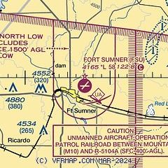
| Sectional chart |
|---|
|
| Airport distance calculator |
|---|
|
|
| Sunrise and sunset |
|---|
|
Times for 12-Jun-2026
| | Local
(UTC-6) | | Zulu
(UTC) |
|---|
| Morning civil twilight | | 05:15 | | 11:15 |
| Sunrise | | 05:45 | | 11:45 |
| Sunset | | 20:09 | | 02:09 |
| Evening civil twilight | | 20:38 | | 02:38 |
|
| Current date and time |
|---|
| Zulu (UTC) | 12-Jun-2026 22:18:54 |
|---|
| Local (UTC-6) | 12-Jun-2026 16:18:54 |
|---|
|
| METAR |
|---|
K4MR
23nm SE | 122143Z AUTO 18013G20KT 10SM FEW065 33/17 A3000 RMK AO2 WSHFT 28 SLP066 $
|
KSXU
34nm NW | 122155Z AUTO 17013G23KT 150V210 10SM CLR 33/14 A3001 RMK AO2
|
KCVS
45nm E | 122055Z AUTO 16013G20KT 10SM SCT055 33/17 A3002 RMK AO2 SLP090 T03260168 57023 $
|
|
| TAF |
|---|
KCVS
45nm E | 121800Z 1218/1324 18010KT 9999 SCT060 QNH3000INS BECMG 1222/1223 18015KT 9999 SCT150 QNH2997INS BECMG 1302/1303 VRB20G40KT 8000 -TSRA OVC050CB QNH2997INS BECMG 1305/1307 24015G25KT 9999 NSW BKN050 QNH2999INS BECMG 1312/1313 20010G20KT 9999 OVC075 QNH3000INS BECMG 1316/1317 24012KT 9999 SCT100 QNH2988INS TX33/1223Z TN20/1310Z
|
|
| NOTAMs |
|---|
NOTAMs are issued by the DoD/FAA and will open in a separate window not controlled by AirNav.
|
|


