FAA INFORMATION EFFECTIVE 14 MAY 2026
Location
| FAA Identifier: | CVN |
| Lat/Long: | 34-25-35.7249N 103-04-39.2881W
34-25.595415N 103-04.654802W
34.4265903,-103.0775800
(estimated) |
| Elevation: | 4215.8 ft. / 1285.0 m (surveyed) |
| Variation: | 09E (2000) |
| From city: | 6 miles E of CLOVIS, NM |
| Time zone: | UTC -6 (UTC -7 during Standard Time) |
| Zip code: | 88135 |
Airport Operations
| Airport use: | Open to the public |
| Activation date: | 04/1959 |
| Control tower: | no |
| ARTCC: | ALBUQUERQUE CENTER |
| FSS: | ALBUQUERQUE FLIGHT SERVICE STATION |
| NOTAMs facility: | CVN (NOTAM-D service available) |
| Attendance: | MON-FRI 0700-1700, ATNDD DAILY 0700-1600 |
| Pattern altitude: | 5015.8 ft. MSL |
| Wind indicator: | lighted |
| Segmented circle: | yes |
| Lights: | ACTVT MALSR RWY 04; REIL RWY 12 & 30; PAPI RWY 04 & 22; MIRL RWY 04/22 & 12/30 - CTAF. PAPI RWY 12 & 30 OPR CONSLY. |
| Beacon: | white-green (lighted land airport)
Operates sunset to sunrise. |
| Fire and rescue: | ARFF index A |
Airport Communications
| CTAF/UNICOM: | 122.8 |
| WX AWOS-3PT: | 135.375 (575-530-9788) |
| CANNON APPROACH: | 118.425 |
| CANNON DEPARTURE: | 118.425 |
| CLEARANCE DELIVERY: | 119.0 |
Nearby radio navigation aids
| VOR radial/distance | | VOR name | | Freq | | Var |
|---|
| TXOr240/12.5 | | TEXICO VORTAC | | 112.20 | | 11E |
Airport Services
| Fuel available: | 100LL JET-A+ |
| Parking: | hangars and tiedowns |
| Airframe service: | NONE |
| Powerplant service: | NONE |
Runway Information
Runway 4/22
| Dimensions: | 7200 x 150 ft. / 2195 x 46 m |
| Surface: | asphalt/aggregate friction seal coat, in good condition |
| Weight bearing capacity: | | Single wheel: | 45.0 | | Double wheel: | 57.0 |
|
| Runway edge lights: | medium intensity |
| RUNWAY 4 | | RUNWAY 22 |
| Latitude: | 34-25.325500N | | 34-26.155833N |
| Longitude: | 103-05.052667W | | 103-04.029333W |
| Elevation: | 4194.3 ft. | | 4214.2 ft. |
| Traffic pattern: | left | | left |
| Runway heading: | 037 magnetic, 046 true | | 217 magnetic, 226 true |
| Markings: | precision, in good condition | | nonprecision, in good condition |
| Visual slope indicator: | 4-light PAPI on left (3.00 degrees glide path) | | 4-light PAPI on left (3.00 degrees glide path) |
| Approach lights: | MALSR: 1,400 foot medium intensity approach lighting system with runway alignment indicator lights | | |
| Touchdown point: | yes, no lights | | yes, no lights |
| Instrument approach: | ILS | | |
| Obstructions: | 12 ft. road, 250 ft. from runway, 510 ft. right of centerline, 4:1 slope to clear
+15 FT ROAD DIST 960 FT 600 FT R; 50:1 FM DTHR. | | none |
Runway 12/30
| Dimensions: | 5697 x 100 ft. / 1736 x 30 m |
| Surface: | asphalt, in good condition |
| Weight bearing capacity: | | Single wheel: | 42.0 | | Double wheel: | 50.0 |
|
| Runway edge lights: | medium intensity |
| RUNWAY 12 | | RUNWAY 30 |
| Latitude: | 34-25.896193N | | 34-25.286627N |
| Longitude: | 103-05.128427W | | 103-04.266337W |
| Elevation: | 4215.8 ft. | | 4187.1 ft. |
| Traffic pattern: | left | | left |
| Runway heading: | 121 magnetic, 130 true | | 301 magnetic, 310 true |
| Markings: | nonprecision, in good condition | | nonprecision, in good condition |
| Visual slope indicator: | 2-light PAPI on left (4.00 degrees glide path) | | 2-light PAPI on left (4.00 degrees glide path) |
| Runway end identifier lights: | yes | | yes |
| Touchdown point: | yes, no lights | | yes, no lights |
| Obstructions: | 16 ft. road, 820 ft. from runway, 320 ft. left of centerline, 38:1 slope to clear | | 10 ft. road, 650 ft. from runway, 280 ft. right of centerline, 45:1 slope to clear |
Runway 8/26
| Dimensions: | 2442 x 75 ft. / 744 x 23 m |
| Surface: | turf, in fair condition |
| RUNWAY 8 | | RUNWAY 26 |
| Latitude: | 34-25.176667N | | 34-25.176333N |
| Longitude: | 103-05.133833W | | 103-04.648167W |
| Elevation: | 4195.7 ft. | | 4185.3 ft. |
| Traffic pattern: | left | | left |
| Runway heading: | 081 magnetic, 090 true | | 261 magnetic, 270 true |
| Obstructions: | 47 ft. pline, 1783 ft. from runway, 37:1 slope to clear | | none |
Airport Ownership and Management from official FAA records
| Ownership: | Publicly-owned |
| Owner: | CITY OF CLOVIS
PO BOX 760
CLOVIS, NM 88101
Phone (575) 769-7890 |
| Manager: | CHRIS MARSHALL
459 CR 11.5
TEXICO, NM 88101
Phone 575-791-3175 |
Additional Remarks
| A39-12/30 | PCR VALUE: 60/F/D/X/T |
| A39-04/22 | PCR VALUE: 90/F/D/X/T |
| - | CTN: JET TFC; CANNON AFB 13 NM SW. |
| - | AGRICULTURE ACT ON & INVOF ARPT. |
| - | FOR CD IF UNA TO CTC ON FSS FREQ, CTC ALBUQUERQUE ARTCC AT 505-856-4561. |
Instrument Procedures
NOTE: All procedures below are presented as PDF files. If you need a reader for these files, you should download the free Adobe Reader.NOT FOR NAVIGATION. Please procure official charts for flight.
FAA instrument procedures published for use from 14 May 2026 at 0901Z to 11 June 2026 at 0900Z.
IAPs - Instrument Approach Procedures |
|---|
| ILS RWY 04 | |
download (183KB) |
| RNAV (GPS) RWY 04 | |
download (217KB) |
| RNAV (GPS) RWY 22 | |
download (190KB) |
| RNAV (GPS) RWY 30 | |
download (214KB) |
| VOR RWY 22 | |
download (194KB) |
| NOTE: Special Alternate Minimums apply | |
download (146KB) |
| NOTE: Special Take-Off Minimums/Departure Procedures apply | |
download (298KB) |
Other nearby airports with instrument procedures:
KCVS - Cannon Air Force Base (12 nm W)
KPRZ - Portales Municipal Airport (24 nm SW)
2T1 - Muleshoe Municipal Airport (26 nm SE)
KHRX - Hereford Municipal Airport (45 nm NE)
KLIU - Littlefield Taylor Brown Municipal Airport (46 nm SE)
|
|

Road maps at:
MapQuest
Bing
Google
| Aerial photo |
|---|
WARNING: Photo may not be current or correct
 Photo by Fred DeGuio
Photo taken 19-Jan-2013
looking south.
Photo by Fred DeGuio
Photo taken 19-Jan-2013
looking south.
Do you have a better or more recent aerial photo of Clovis Regional Airport that you would like to share? If so, please send us your photo.
|
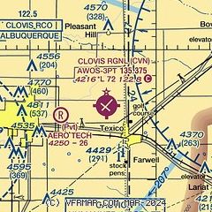
| Sectional chart |
|---|
|
| Airport distance calculator |
|---|
|
|
| Sunrise and sunset |
|---|
|
Times for 31-May-2026
| | Local
(UTC-6) | | Zulu
(UTC) |
|---|
| Morning civil twilight | | 05:13 | | 11:13 |
| Sunrise | | 05:42 | | 11:42 |
| Sunset | | 19:58 | | 01:58 |
| Evening civil twilight | | 20:27 | | 02:27 |
|
| Current date and time |
|---|
| Zulu (UTC) | 31-May-2026 09:44:55 |
|---|
| Local (UTC-6) | 31-May-2026 03:44:55 |
|---|
|
| METAR |
|---|
| KCVN | 310856Z AUTO 29003KT 10SM CLR 15/02 A2995 RMK AO2 SLP102 T01500022 53001 $
|
KCVS
12nm W | 310855Z AUTO 30007KT 10SM CLR 18/01 A2993 RMK AO2 SLP069 T01830013 53003 $
|
|
| TAF |
|---|
KCVS
12nm W | 301000Z 3010/3116 23009KT 9999 SKC QNH2985INS BECMG 3108/3109 VRB06KT 9999 SKC QNH2994INS TX31/3021Z TN14/3110Z
|
|
| NOTAMs |
|---|
NOTAMs are issued by the DoD/FAA and will open in a separate window not controlled by AirNav.
|
|


