FAA INFORMATION EFFECTIVE 25 DECEMBER 2025
Location
| FAA Identifier: | HEZ |
| Lat/Long: | 31-36-49.1800N 091-17-50.4080W
31-36.819667N 091-17.840133W
31.6136611,-91.2973356
(estimated) |
| Elevation: | 272.4 ft. / 83.0 m (surveyed) |
| Variation: | 00E (2015) |
| From city: | 6 miles NE of NATCHEZ, MS |
| Time zone: | UTC -6 (UTC -5 during Daylight Saving Time) |
| Zip code: | 39120 |
Airport Operations
| Airport use: | Open to the public |
| Activation date: | 12/1944 |
| Control tower: | no |
| ARTCC: | HOUSTON CENTER |
| FSS: | GREENWOOD FLIGHT SERVICE STATION |
| NOTAMs facility: | HEZ (NOTAM-D service available) |
| Attendance: | 0600-2000 |
| Wind indicator: | lighted |
| Segmented circle: | yes |
| Lights: | ACTVT MALSR RWY 14; PAPI RWY 14 & 32; VASI RWY 18; MIRL RWY 18/36 - CTAF. |
| Beacon: | white-green (lighted land airport)
Operates sunset to sunrise. |
| Fire and rescue: | ARFF index A |
| Airline operations: | CLSD TO UNSKED ACR OPS WITH MORE THAN 30 PAX SEATS EXCP 48 HR PPR CALL AMGR. |
Airport Communications
| CTAF/UNICOM: | 122.8 |
| WX AWOS-3PT: | 124.675 (601-446-8022) |
| WX AWOS-3 at 0R4 (11 nm W): | 118.2 (318-336-8028) |
- APCH/DEP SVC PRVDD BY HOUSTON ARTCC (ZHU) ON FREQS 120.975/299.6 (NATCHEZ RCAG).
Nearby radio navigation aids
Airport Services
| Fuel available: | 100LL JET-A |
| Parking: | hangars and tiedowns |
| Airframe service: | MINOR |
| Powerplant service: | MINOR |
| Bottled oxygen: | NONE |
| Bulk oxygen: | NONE |
Runway Information
Runway 14/32
| Dimensions: | 6500 x 150 ft. / 1981 x 46 m |
| Surface: | asphalt/grooved, in excellent condition |
| Weight bearing capacity: | | Single wheel: | 50.0 | | Double wheel: | 78.0 | | Double tandem: | 172.0 |
|
| Runway edge lights: | high intensity |
| RUNWAY 14 | | RUNWAY 32 |
| Latitude: | 31-37.234703N | | 31-36.459282N |
| Longitude: | 091-18.353913W | | 091-17.488778W |
| Elevation: | 261.5 ft. | | 269.3 ft. |
| Traffic pattern: | left | | left |
| Runway heading: | 136 | | 316 |
| Markings: | precision, in good condition | | nonprecision, in good condition |
| Visual slope indicator: | 4-light PAPI on right (3.00 degrees glide path) | | 4-light PAPI on left (3.00 degrees glide path) |
| Approach lights: | MALSR: 1,400 foot medium intensity approach lighting system with runway alignment indicator lights | | |
| Touchdown point: | yes, no lights | | yes, no lights |
| Instrument approach: | ILS | | |
| Obstructions: | none | | 78 ft. trees, 2400 ft. from runway, 250 ft. both sides of centerline, 28:1 slope to clear |
Runway 18/36
| Dimensions: | 5000 x 150 ft. / 1524 x 46 m |
| Surface: | asphalt, in poor condition
WIDESPREAD CRACKING & UNEVEN PAVEMENT. |
| Weight bearing capacity: | | PCN 35 /F/B/Y/T | | Single wheel: | 83.0 | | Double wheel: | 113.0 | | Double tandem: | 65.0 |
|
| Runway edge lights: | medium intensity |
| Runway edge markings: | MARKINGS FADED. |
| Operational restrictions: | RWY 18/36 NOT AVBL FOR PART 121/PART 380 OPS WITH SKED PAX CARRYING OPS MORE THAN 9 PAX SEATS AND NON-SKED PAX CARRYING OPS MORE THAN 30 PAX SEATS. |
| RUNWAY 18 | | RUNWAY 36 |
| Latitude: | 31-37.196390N | | 31-36.371825N |
| Longitude: | 091-17.727435W | | 091-17.741758W |
| Elevation: | 269.4 ft. | | 260.2 ft. |
| Traffic pattern: | left | | left |
| Runway heading: | 181 | | 001 |
| Markings: | nonprecision, in poor condition | | nonprecision, in poor condition |
| Visual slope indicator: | 4-box VASI on left (3.00 degrees glide path) | | |
| Touchdown point: | yes, no lights | | yes, no lights |
| Obstructions: | none | | 63 ft. trees, 1400 ft. from runway, 300 ft. right of centerline, 19:1 slope to clear |
Airport Ownership and Management from official FAA records
| Ownership: | Publicly-owned |
| Owner: | ADAMS COUNTY
BOX 1008
NATCHEZ, MS 39121
Phone 601-442-2431 |
| Manager: | RICHARD NELSON
434 AIRPORT RD
NATCHEZ, MS 39120
Phone 601-442-5171 |
Additional Remarks
| A39-14/32 | PCR VALUE: 45/F/B/X/T |
| - | GND PWR UNIT AVBL ON FLD. |
| - | DEER ON & INVOF RWYS. |
| - | TWY A & C1 NOT AVBL FOR ACR USE. |
Instrument Procedures
NOTE: All procedures below are presented as PDF files. If you need a reader for these files, you should download the free Adobe Reader.NOT FOR NAVIGATION. Please procure official charts for flight.
FAA instrument procedures published for use from 25 December 2025 at 0901z to 22 January 2026 at 0900z.
IAPs - Instrument Approach Procedures |
|---|
| ILS OR LOC RWY 14 | |
download (234KB) |
| RNAV (GPS) RWY 14 | |
download (234KB) |
| RNAV (GPS) RWY 18 | |
download (204KB) |
| RNAV (GPS) RWY 32 | |
download (210KB) |
| RNAV (GPS) RWY 36 | |
download (230KB) |
| NOTE: Special Alternate Minimums apply | |
download (162KB) |
| NOTE: Special Take-Off Minimums/Departure Procedures apply | |
download (308KB) |
Other nearby airports with instrument procedures:
0R4 - Concordia Parish Airport (11 nm W)
KVKS - Vicksburg Municipal Airport (42 nm NE)
1R7 - Brookhaven-Lincoln County Airport (45 nm E)
KTVR - Vicksburg Tallulah Regional Airport (46 nm N)
KMCB - Mc Comb (Pike County) Airport/John E Lewis Field (50 nm SE)
|
|

Road maps at:
MapQuest
Bing
Google
| Aerial photo |
|---|
WARNING: Photo may not be current or correct
 Photo taken 16-Dec-2013
looking north-northwest.
Photo taken 16-Dec-2013
looking north-northwest.
Do you have a better or more recent aerial photo of Hardy-Anders Field/Natchez-Adams County Airport that you would like to share? If so, please send us your photo.
|
| Sectional chart |
|---|
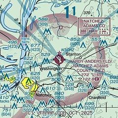
|
| Airport distance calculator |
|---|
|
|
| Sunrise and sunset |
|---|
|
Times for 20-Jan-2026
| | Local
(UTC-6) | | Zulu
(UTC) |
|---|
| Morning civil twilight | | 06:39 | | 12:39 |
| Sunrise | | 07:05 | | 13:05 |
| Sunset | | 17:28 | | 23:28 |
| Evening civil twilight | | 17:54 | | 23:54 |
|
| Current date and time |
|---|
| Zulu (UTC) | 20-Jan-2026 20:45:47 |
|---|
| Local (UTC-6) | 20-Jan-2026 14:45:47 |
|---|
|
| METAR |
|---|
| KHEZ | 201956Z AUTO 24004KT 10SM CLR 16/00 A3041 RMK AO2 SLP298 T01560000 $
|
K0R4
11nm W | 202035Z AUTO 21004KT 10SM CLR 19/01 A3043 RMK AO2 T01910008
|
|
| TAF |
|---|
| KHEZ | 201737Z 2018/2118 11005KT P6SM SCT250 FM202300 00000KT P6SM FEW250 FM210200 VRB04KT P6SM FEW250 FM210700 15006KT P6SM BKN090 FM211300 15008KT P6SM BKN060 FM211700 16009KT P6SM OVC035
|
|
| NOTAMs |
|---|
NOTAMs are issued by the DoD/FAA and will open in a separate window not controlled by AirNav.
|
|

