FAA INFORMATION EFFECTIVE 25 DECEMBER 2025
Location
| FAA Identifier: | HLN |
| Lat/Long: | 46-36-24.2000N 111-58-59.8000W
46-36.403333N 111-58.996667W
46.6067222,-111.9832778
(estimated) |
| Elevation: | 3877.3 ft. / 1181.8 m (surveyed) |
| Variation: | 12E (2025) |
| From city: | 2 miles NE of HELENA, MT |
| Time zone: | UTC -7 (UTC -6 during Daylight Saving Time) |
| Zip code: | 59601 |
Airport Operations
| Airport use: | Open to the public |
| Activation date: | 04/1940 |
| Control tower: | yes |
| ARTCC: | SALT LAKE CITY CENTER |
| FSS: | GREAT FALLS FLIGHT SERVICE STATION |
| NOTAMs facility: | HLN (NOTAM-D service available) |
| Attendance: | 0500-0100 |
| Wind indicator: | lighted |
| Segmented circle: | yes |
| Lights: | WHEN ATCT CLSD ACTVT MALSR RWY 27; REIL RWY 09, 17 & 35; PAPI RWY 09 & 27; HIRL RWY 09/27; MIRL RWY 05/23 & 17/35 - CTAF. |
| Beacon: | white-green (lighted land airport)
Operates sunset to sunrise. |
| Landing fee: | yes |
| Fire and rescue: | ARFF index B |
| Airline operations: | ARFF PRVDD FOR SKED PART 121 ACR; OTRW PRIOR APVL RQRD - AMGR. |
| International operations: | customs landing rights airport
CUST - 406-449-5506. |
Airport Communications
| CTAF: | 118.3 |
| UNICOM: | 122.95 |
| ATIS: | 120.4 |
| WX ASOS: | 120.4 (406-290-3397) |
| HELENA GROUND: | 121.9 [0600-2200] |
| HELENA TOWER: | 118.3 257.8 [0600-2200] |
| HELENA APPROACH: | 119.5 229.4 [0600-2200] |
| HELENA DEPARTURE: | 119.5 229.4 [0600-2200] |
| ARNG OPS: | 126.2 321.45 40.65FM |
| EMERG: | 121.5 243.0 |
- APCH/DEP CTL SVC PRVDD BY SALT LAKE ARTCC (ZLC) ON FREQS 133.4/285.4 (BUTTE RCAG) WHEN HELENA APCH CTL (HLN) CLSD.
Nearby radio navigation aids
| VOR radial/distance | | VOR name | | Freq | | Var |
|---|
| HLNr258/1.2 | | HELENA VORTAC | | 117.70 | | 12E |
| NDB name | | Hdg/Dist | | Freq | | Var | | ID |
|---|
| HAUSER | | 272/9.6 | | 386 | | 12E | | HAU | .... .- ..- |
Airport Services
| Fuel available: | 100 100LL JET-A |
| Parking: | hangars and tiedowns |
| Airframe service: | MAJOR |
| Powerplant service: | MAJOR |
| Bottled oxygen: | HIGH |
| Bulk oxygen: | HIGH |
Runway Information
Runway 9/27
| Dimensions: | 9000 x 150 ft. / 2743 x 46 m |
| Surface: | asphalt/porous friction courses, in good condition |
| Weight bearing capacity: | | Double wheel: | 160.0 | | Double tandem: | 250.0 | | Dual double tandem: | 420.0 |
|
| Runway edge lights: | high intensity |
| RUNWAY 9 | | RUNWAY 27 |
| Latitude: | 46-36.504810N | | 46-36.179333N |
| Longitude: | 111-59.861282W | | 111-57.765917W |
| Elevation: | 3863.7 ft. | | 3844.8 ft. |
| Traffic pattern: | left | | right |
| Runway heading: | 090 magnetic, 102 true | | 270 magnetic, 282 true |
| Declared distances: | TORA:9000 TODA:9000 ASDA:9000 LDA:9000 | | TORA:9000 TODA:9000 ASDA:9000 LDA:9000 |
| Markings: | precision, in good condition | | precision, in good condition |
| Visual slope indicator: | 4-light PAPI on left (3.30 degrees glide path) | | 4-light PAPI on left (3.00 degrees glide path) |
| Approach lights: | | | MALSR: 1,400 foot medium intensity approach lighting system with runway alignment indicator lights |
| Runway end identifier lights: | yes | | |
| Touchdown point: | yes, no lights | | yes, no lights |
| Instrument approach: | | | ILS |
| Obstructions: | 6 ft. gnd, 200 ft. from runway, 350 ft. right of centerline, 34:1 slope to clear
+6 FT GND 0-200 FT FM RWY END 350 FT R. | | none |
Runway 5/23
| Dimensions: | 4644 x 75 ft. / 1415 x 23 m |
| Surface: | asphalt/porous friction courses, in fair condition |
| Weight bearing capacity: | | Single wheel: | 21.0 | | Double wheel: | 30.0 |
|
| Runway edge lights: | medium intensity |
| Operational restrictions: | RWY 05/23 NOT AVBL FOR PART 121/PART 380 OPS WITH SKED PAX CARRYING OPS MORE THAN 9 PAX SEATS AND NON-SKED PAX CARRYING OPS MORE THAN 30 PAX SEATS. NO PART 121/PART 380 OPS EXC BTN TWY F & TWY C. |
| RUNWAY 5 | | RUNWAY 23 |
| Latitude: | 46-36.335808N | | 46-36.643557N |
| Longitude: | 111-59.846665W | | 111-58.832233W |
| Elevation: | 3877.2 ft. | | 3819.6 ft. |
| Traffic pattern: | left | | right |
| Runway heading: | 054 magnetic, 066 true | | 234 magnetic, 246 true |
| Declared distances: | TORA:4644 TODA:4644 ASDA:4644 LDA:4644 | | TORA:4644 TODA:4644 ASDA:4644 LDA:4644 |
| Markings: | basic, in good condition | | basic, in good condition |
| Visual slope indicator: | 2-light PAPI on left (3.00 degrees glide path) | | 2-light PAPI on left (3.00 degrees glide path) |
| Touchdown point: | yes, no lights | | yes, no lights |
| Obstructions: | 22 ft. road, 425 ft. from runway, 136 ft. left of centerline, 10:1 slope to clear | | 8 ft. fence, marked, 550 ft. from runway, 165 ft. left of centerline, 43:1 slope to clear |
Runway 17/35
| Dimensions: | 2989 x 75 ft. / 911 x 23 m |
| Surface: | asphalt/porous friction courses, in fair condition |
| Runway edge lights: | medium intensity |
| Operational restrictions: | RWY 17/35 NOT AVBL FOR PART 121/PART 380 OPS WITH SKED PAX CARRYING OPS MORE THAN 9 PAX SEATS AND NON-SKED PAX CARRYING OPS MORE THAN 30 PAX SEATS. NO PART 121/PART 380 OPS EXC BTN TWY F & TWY C. |
| RUNWAY 17 | | RUNWAY 35 |
| Latitude: | 46-36.730342N | | 46-36.238777N |
| Longitude: | 111-58.846340W | | 111-58.838160W |
| Elevation: | 3811.9 ft. | | 3862.3 ft. |
| Traffic pattern: | left | | right |
| Runway heading: | 167 magnetic, 179 true | | 347 magnetic, 359 true |
| Declared distances: | TORA:2989 TODA:2989 ASDA:2989 LDA:2989 | | TORA:2989 TODA:2989 ASDA:2989 LDA:2989 |
| Markings: | basic, in good condition | | basic, in good condition |
| Runway end identifier lights: | yes | | yes |
| Touchdown point: | yes, no lights | | yes, no lights |
| Obstructions: | none | | 4 ft. gnd, 200 ft. from runway, 20:1 slope to clear
+4 FT GND 0-200 FT FM RWY END 0-125 FT L & R. |
Runway 10/28
| Dimensions: | 1584 x 75 ft. / 483 x 23 m |
| Surface: | turf |
| RUNWAY 10 | | RUNWAY 28 |
| Latitude: | 46-36.375213N | | 46-36.317663N |
| Longitude: | 111-59.513895W | | 111-59.145137W |
| Elevation: | 3855.9 ft. | | 3850.7 ft. |
| Traffic pattern: | left | | left |
| Runway heading: | 091 magnetic, 103 true | | 271 magnetic, 283 true |
| Touchdown point: | yes, no lights | | yes, no lights |
Airport Ownership and Management from official FAA records
| Ownership: | Publicly-owned |
| Owner: | HELENA REG ARPT AUTH
2850 MERCER LOOP
HELENA, MT 59602
Phone 406-442-2821 |
| Manager: | JEFF WADEKAMPER
2850 MERCER LOOP
HELENA, MT 59602
Phone 406-442-2821 |
Additional Remarks
| A39-05/23 | PCR VALUE: 300/F/D/X/T |
| A39-09/27 | PCR VALUE: 790/F/D/X/T |
| A39-17/35 | PCR VALUE: 460/F/D/X/T |
| - | FLIGHT NOTIFICATION SERVICE (ADCUS) AVBL. |
| - | ARNG: FT HARRISON AAF WI CLASS D; PAJA - MT ARNG OPS C406 324-5775/76, D324-5775/76. |
| - | FOR CD IF UNA TO CTC ON FSS FREQ, CTC SALT LAKE ARTCC AT 801-320-2568. |
| - | LNDG FEE GTR THAN 10000 LB. |
| - | TWY A, B, & C BTN TWY A & RWY 35 NOT AVBL TO ACR GTR THAN 30 PAX SEATS. |
| - | ARNG OPS 1400-0030Z++ MON-FRI, EXC HOL. CTN DURG TAX; AASF RAMP NOT STRESSED FOR LRG ACFT. RAMP ADVSY - 126.2, D406-324-5775, C406-324-5775. TSNT SVC NA AFT 2300Z++ MON-FRI; WKEND & HOL. |
| - | FUEL SVC- 406-442-2190. |
| - | COLD TEMPERATURE AIRPORT. ALTITUDE CORRECTION REQUIRED AT OR BELOW -16C. |
Instrument Procedures
NOTE: All procedures below are presented as PDF files. If you need a reader for these files, you should download the free Adobe Reader.NOT FOR NAVIGATION. Please procure official charts for flight.
FAA instrument procedures published for use from 25 December 2025 at 0901z to 22 January 2026 at 0900z.
IAPs - Instrument Approach Procedures |
|---|
| ILS Y OR LOC Y RWY 27 | |
download (722KB) |
| ILS Z OR LOC Z RWY 27 | |
download (511KB) |
| RNAV (RNP) Y RWY 27 | |
download (471KB) |
| RNAV (RNP) Z RWY 09 | |
download (440KB) |
| RNAV (RNP) Z RWY 27 | |
download (466KB) |
| RNAV (GPS) X RWY 27 | |
download (399KB) |
| RNAV (GPS) Y RWY 09 | |
download (477KB) |
| LOC BC-C | |
download (477KB) |
| VOR-A | |
download (383KB) |
| VOR-B | |
download (483KB) |
| COPTER VOR 258 | |
download (222KB) |
| NOTE: Special Alternate Minimums apply | |
download (210KB) |
Departure Procedures |
|---|
| HELENA FIVE | |
download (138KB) |
| SIEBE FOUR | |
download (130KB) |
| STAKK FIVE | |
download (248KB) |
|
|---|
| DIVIDE TWO (OBSTACLE) | |
download (333KB) |
| NOTE: Special Take-Off Minimums/Departure Procedures apply | |
download (560KB) |
Other nearby airports with instrument procedures:
38S - Deer Lodge-City-County Airport (35 nm W)
KBTM - Bert Mooney Airport (45 nm SW)
7S6 - White Sulphur Springs Airport (45 nm E)
3U3 - Bowman Field Airport (46 nm SW)
KGTF - Great Falls International Airport (58 nm NE)
|
|

Road maps at:
MapQuest
Bing
Google
| Aerial photo |
|---|
WARNING: Photo may not be current or correct
 Photo by Fred LeLacheur
Taken in July 2015
looking east
Photo by Fred LeLacheur
Taken in July 2015
looking east
Do you have a better or more recent aerial photo of Helena Regional Airport that you would like to share? If so, please send us your photo.
|
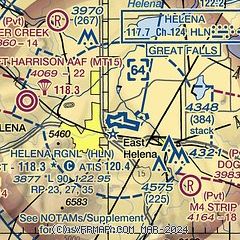
| Sectional chart |
|---|
|
 Download PDF
of official airport diagram from the FAA
| Airport distance calculator |
|---|
|
|
| Sunrise and sunset |
|---|
|
Times for 02-Jan-2026
| | Local
(UTC-7) | | Zulu
(UTC) |
|---|
| Morning civil twilight | | 07:38 | | 14:38 |
| Sunrise | | 08:13 | | 15:13 |
| Sunset | | 16:51 | | 23:51 |
| Evening civil twilight | | 17:26 | | 00:26 |
|
| Current date and time |
|---|
| Zulu (UTC) | 02-Jan-2026 12:32:26 |
|---|
| Local (UTC-7) | 02-Jan-2026 05:32:26 |
|---|
|
| METAR |
|---|
| KHLN | 021153Z AUTO 00000KT 10SM OVC065 01/M02 A2978 RMK AO2 SLP121 60002 70002 T00061017 10011 21006 51006
|
|
| TAF |
|---|
| KHLN | 021136Z 0212/0312 00000KT P6SM OVC050 TEMPO 0212/0213 4SM -RA OVC025 FM021700 VRB03KT P6SM BKN050
|
|
| NOTAMs |
|---|
NOTAMs are issued by the DoD/FAA and will open in a separate window not controlled by AirNav.
|
|


