FAA INFORMATION EFFECTIVE 18 APRIL 2024
Location
| FAA Identifier: | HOM |
| Lat/Long: | 59-38-41.9819N 151-29-08.9103W
59-38.699698N 151-29.148505W
59.6449950,-151.4858084
(estimated) |
| Elevation: | 84.3 ft. / 25.7 m (surveyed) |
| Variation: | 17E (2015) |
| From city: | 2 miles E of HOMER, AK |
| Time zone: | UTC -8 (UTC -9 during Standard Time) |
| Zip code: | 99603 |
Airport Operations
| Airport use: | Open to the public |
| Activation date: | 05/1947 |
| Control tower: | no |
| ARTCC: | ANCHORAGE CENTER |
| FSS: | HOMER FLIGHT SERVICE STATION (on field) [907-235-8588] |
| Alternate FSS: | ENA KENAI FLIGHT SERVICE STATION [1-866-864-1737] |
| NOTAMs facility: | HOM (NOTAM-D service available) |
| Attendance: | NOV-MAR 0400-2100, APR-OCT 0600-2100 |
| Pattern altitude: | 884.3 ft. MSL |
| Wind indicator: | lighted |
| Segmented circle: | yes |
| Lights: | ACTVT MALSF RWY 04; MALSR RWY 22; VASI RWY 04 & 22; HIRL RWY 04/22 - CTAF. |
| Beacon: | white-green (lighted land airport)
Operates sunset to sunrise. |
| Fire and rescue: | ARFF index A |
| Airline operations: | DURG ACR OPS ONLY.
PPR FOR ACR OPNS WITH MORE THAN 30 PSGR SEATS WRITE AMGR: 2320 KACHEMAK DR. HOMER; AK 99603. |
Airport Communications
| CTAF: | 123.6 |
| UNICOM: | 123.0 |
| WX ASOS: | 135.65 (907-235-3603) |
| AFIS: | 135.65 |
| WX ASOS at SOV (14 nm SW): | 135.4 (907-234-7407) |
- OR 122.700 & 123.050.
- APCH/DEP SVC PRVDD BY ANCHORAGE ARTCC ON FREQS 125.9/270.3 (HOMER RCAG).
- HOM AFIS ON FREQUENCY 135.65. OPERATES SAME HRS AS HOM FSS, 0600-2130; OT CTC KENI FSS.
- COMMUNICATIONS PRVDD BY HOMER FSS ON FREQ 123.6 (CTAF).
Nearby radio navigation aids
| VOR radial/distance | | VOR name | | Freq | | Var |
|---|
| HOMr178/4.0 | | HOMER VOR/DME | | 114.60 | | 15E |
| NDB name | | Hdg/Dist | | Freq | | Var | | ID |
|---|
| KACHEMAK | | at field | | 277 | | 17E | | ACE | .- -.-. . |
Airport Services
| Fuel available: | 100LL JET-A |
| Parking: | hangars and tiedowns |
| Airframe service: | MINOR |
| Powerplant service: | MINOR |
| Bottled oxygen: | NONE |
| Bulk oxygen: | NONE |
Runway Information
Runway 4/22
| Dimensions: | 6701 x 150 ft. / 2042 x 46 m |
| Surface: | asphalt/grooved, in poor condition |
| Weight bearing capacity: | | PCN 55 /F/B/X/T | | Single wheel: | 62.0 | | Double wheel: | 70.0 | | Double tandem: | 189.0 |
|
| Runway edge lights: | high intensity |
| RUNWAY 4 | | RUNWAY 22 |
| Latitude: | 59-38.417545N | | 59-39.048183N |
| Longitude: | 151-29.485825W | | 151-27.705252W |
| Elevation: | 70.5 ft. | | 74.3 ft. |
| Traffic pattern: | right | | left |
| Runway heading: | 038 magnetic, 055 true | | 218 magnetic, 235 true |
| Markings: | precision, in poor condition | | precision, in fair condition |
| Visual slope indicator: | 4-box VASI on left (3.00 degrees glide path) | | 4-box VASI on left (3.00 degrees glide path) |
| Approach lights: | MALSF: 1,400 foot medium intensity approach lighting system with sequenced flashers | | MALSR: 1,400 foot medium intensity approach lighting system with runway alignment indicator lights |
| Runway end identifier lights: | no | | no |
| Touchdown point: | yes, no lights | | yes, no lights |
| Instrument approach: | LOC/DME | | MLS |
| Obstructions: | 31 ft. ant, lighted, 522 ft. from runway, 520 ft. left of centerline, 10:1 slope to clear | | 74 ft. tree, 2269 ft. from runway, 425 ft. right of centerline, 27:1 slope to clear |
Runway 6W/24W
| Dimensions: | 2501 x 100 ft. / 762 x 30 m |
| Surface: | water |
| RUNWAY 6W | | RUNWAY 24W |
| Latitude: | 59-38.496667N | | 59-38.725000N |
| Longitude: | 151-30.967167W | | 151-30.293000W |
| Elevation: | 18.0 ft. | | 18.0 ft. |
| Traffic pattern: | left | | left |
Airport Ownership and Management from official FAA records
| Ownership: | Publicly-owned |
| Owner: | ALASKA DOT&PF CENTRAL REGION
PO BOX 196900
ANCHORAGE, AK 99519-6900
Phone 907-269-0783 |
| Manager: | KEVIN JONES
2320 KACHEMAK DR
HOMER, AK 99603
Phone 907-235-5217
LVE MSG OR 907-235-4394. |
Airport Operational Statistics
| Aircraft based on the field: | | 93 | | Single engine airplanes: | | 84 | | Multi engine airplanes: | | 4 | | Helicopters: | | 3 | | Ultralights: | | 2 |
| |  | |
| Aircraft operations: avg 148/day * | | 61% | commercial | | 20% | air taxi | | 10% | local general aviation | | 8% | transient general aviation | | <1% | military | | * for 12-month period ending 31 December 2020 | |
Additional Remarks
| - | NO LINE OF SIGHT BTN RWY ENDS. |
| - | 365 FT UNLGT TWR 9 NM W. |
| - | PAEW MAY BE ON RWY H24. |
| - | TPA 800 FT AGL FOR FIXED WING ACFT; TPA 600 FT AGL & BLO FOR ROTARY ACFT. |
| - | RWY COND, SNOW/ICE RPRT & REMOVAL, WILDLIFE CTL OR OTR SVC AVBL DURG SKED MAINT HR; AFT HR SVC - AMGR. |
| - | TWY A, B SOUTH, D & E CLSD TO ACFT OVR 12500 LB. |
| - | SAND GRADATION LRGR THAN FAA RCMDD; SEE AC150/5200-30. |
| - | WX CAMERA AVBL ON INTERNET AT HTTP://WEATHERCAMS.FAA.GOV. |
| - | SEA BIRDS & WATER FOWL ON & INVOF ARPT DURG SPRING & SUMMER. |
| - | NOISE ABATEMENT IN EFCT H24; TURNS BFR DEP END RWY 04/22 NA AT HOMER & SPB; RPRT OBS DEV TO FAA SAFETY HOTLINE. |
| - | GA TSNT PRKG S SIDE OF RWY. |
| - | GRVL ROAD S SIDE OF RWY CLSD TO ACFT; TAX NA. |
Instrument Procedures
NOTE: All procedures below are presented as PDF files. If you need a reader for these files, you should download the free Adobe Reader.NOT FOR NAVIGATION. Please procure official charts for flight.
FAA instrument procedures published for use from 18 April 2024 at 0901Z to 16 May 2024 at 0900Z.
IAPs - Instrument Approach Procedures |
|---|
| RNAV (GPS) Y RWY 04 | |
download (276KB) |
| RNAV (GPS) Y RWY 22 **CHANGED** | |
download (279KB) |
| RNAV (GPS) Z RWY 04 | |
download (280KB) |
| RNAV (GPS) Z RWY 22 | |
download (248KB) |
| LOC BC RWY 22 | |
download (349KB) |
| LOC RWY 04 | |
download (354KB) |
| NOTE: Special Alternate Minimums apply | |
download (172KB) |
| NOTE: Special Take-Off Minimums/Departure Procedures apply | |
download (307KB) |
Other nearby airports with instrument procedures:
PASX - Soldotna Airport (52 nm N)
PAEN - Kenai Municipal Airport (56 nm N)
PAWD - Seward Airport (69 nm NE)
PAKX - Wilder Runway Airport (92 nm W)
|
|

Road maps at:
MapQuest
Bing
Google
| Aerial photo |
|---|
WARNING: Photo may not be current or correct
 Photo by Vicki Eifert
Photo taken 07-Jun-2018
looking south.
Photo by Vicki Eifert
Photo taken 07-Jun-2018
looking south.
Do you have a better or more recent aerial photo of Homer Airport that you would like to share? If so, please send us your photo.
|
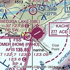
| Sectional chart |
|---|
|
| Airport distance calculator |
|---|
|
|
| Sunrise and sunset |
|---|
|
Times for 24-Apr-2024
| | Local
(UTC-8) | | Zulu
(UTC) |
|---|
| Morning civil twilight | | 05:33 | | 13:33 |
| Sunrise | | 06:22 | | 14:22 |
| Sunset | | 21:46 | | 05:46 |
| Evening civil twilight | | 22:35 | | 06:35 |
|
| Current date and time |
|---|
| Zulu (UTC) | 24-Apr-2024 11:42:04 |
|---|
| Local (UTC-8) | 24-Apr-2024 03:42:04 |
|---|
|
| METAR |
|---|
| PAHO | 241053Z AUTO 07003KT 10SM OVC090 04/01 A2987 RMK AO2 SLP117 T00390011 TSNO $
|
PASO
13nm SW | 241053Z AUTO 14006KT 10SM OVC039 06/02 A2987 RMK AO2 SLP116 T00610017 TSNO
|
|
| TAF |
|---|
| PAHO | 240520Z 2406/2506 VRB03KT P6SM OVC060
|
|
| NOTAMs |
|---|
NOTAMs are issued by the DoD/FAA and will open in a separate window not controlled by AirNav.
|
|

