FAA INFORMATION EFFECTIVE 14 MAY 2026
Location
| FAA Identifier: | SWD |
| Lat/Long: | 60-07-47.5891N 149-24-59.8660W
60-07.793152N 149-24.997767W
60.1298859,-149.4166294
(estimated) |
| Elevation: | 27.7 ft. / 8 m (estimated) |
| Variation: | 19E (2010) |
| From city: | 2 miles NE of SEWARD, AK |
| Time zone: | UTC -8 (UTC -9 during Standard Time) |
| Zip code: | 99664 |
Airport Operations
| Airport use: | Open to the public |
| Activation date: | 04/1947 |
| Control tower: | no |
| ARTCC: | ANCHORAGE CENTER |
| FSS: | KENAI FLIGHT SERVICE STATION [907-283-7211] |
| NOTAMs facility: | SWD (NOTAM-D service available) |
| Attendance: | UNATNDD |
| Pattern altitude: | TPA FIXED WING 1000 FT AGL. RWYS 31 & 34 ARRIVALS MAINTAIN AT LEAST 800 FT AGL UNTIL TURNING FINAL. RWYS 13 & 16 DEPARTURES CLIMB STRAIGHT AHEAD TO AT LEAST 800 FT AGL BEFORE TURNING WESTBOUND. |
| Wind indicator: | yes |
| Segmented circle: | yes |
| Lights: | ACTVT VASI RWY 31; MIRL RWY 13/31 - CTAF. |
| Beacon: | white-green (lighted land airport)
Operates sunset to sunrise. |
Airport Communications
| CTAF: | 122.9 |
| WX ASOS: | 135.2 (907-224-2440) |
- APCH/DEP SVC PRVDD BY ANCHORAGE ARTCC ON FREQS. 119.7/269.0 (KENAI RCAG) .
- COMMUNICATIONS PRVDD BY KENAI FSS ON FREQ 122.6 (SEWARD RCO).
Airport Services
| Fuel available: | 100LL JET-A |
| Parking: | hangars and tiedowns |
Runway Information
Runway 13/31
| Dimensions: | 4249 x 100 ft. / 1295 x 30 m |
| Surface: | asphalt, in good condition |
| Runway edge lights: | medium intensity |
| RUNWAY 13 | | RUNWAY 31 |
| Latitude: | 60-08.062500N | | 60-07.481500N |
| Longitude: | 149-25.260167W | | 149-24.486500W |
| Elevation: | 27.7 ft. | | 18.7 ft. |
| Traffic pattern: | left | | left |
| Runway heading: | 127 magnetic, 146 true | | 307 magnetic, 326 true |
| Markings: | basic, in good condition | | basic, in good condition |
| Visual slope indicator: | | | 4-box VASI on left (3.00 degrees glide path)
RWY 31 VASI UNUSBL BYD 5 DEG RIGHT OF CNTRLN; OFFSET 5 DEG CLKWS FM CNTRLN. RWY 31 VASI UNUSBL BYD 3 NM; OBSTN CLNC BYD 3 NM NA. |
| Touchdown point: | yes, no lights | | yes, no lights |
| Obstructions: | 6 ft. brdg, 200 ft. from runway, 90 ft. right of centerline
CTLG OBSTN EXCEEDS 45 DEG SLOPE. | | 5 ft. brush, 202 ft. from runway, 35 ft. left of centerline
TREES & SHRUBS 100 FT FM RWY END BOTH SIDES. |
Runway 16/34
| Dimensions: | 2289 x 75 ft. / 698 x 23 m |
| Surface: | asphalt, in good condition |
| Operational restrictions: | DURG WINTER 4 IN DIP 15 IN WIDE FM NORTH THR. |
| RUNWAY 16 | | RUNWAY 34 |
| Latitude: | 60-08.020000N | | 60-07.644833N |
| Longitude: | 149-25.251167W | | 149-25.206333W |
| Elevation: | 25.4 ft. | | 17.4 ft. |
| Traffic pattern: | left | | left |
| Runway heading: | 158 magnetic, 177 true | | 338 magnetic, 357 true |
| Markings: | basic, in good condition | | basic, in good condition |
| Touchdown point: | yes, no lights | | yes, no lights |
| Obstructions: | 68 ft. trees, 885 ft. from runway, 220 ft. left of centerline, 10:1 slope to clear | | none
TREES & SHRUBS 0-200 FT FM THR BOTH SIDES. |
Airport Ownership and Management from official FAA records
| Ownership: | Publicly-owned |
| Owner: | ALASKA DOT&PF CENTRAL REGION
PO BOX 196900
ANCHORAGE, AK 99519-6900
Phone 907-262-2199 |
| Manager: | JOSEPH (JD) BOYLE
30049 SEWARD HWY MP 23.9, P.O. BOX 1327
SEWARD, AK 99664
Phone 907-262-1187 |
Additional Remarks
| A30A-31 | APCH SLOPE 0:1. |
| - | WX CAMERA AVBL ON INTERNET AT HTTPS://WEATHERCAMS.FAA.GOV |
| - | BIRDS WI 10 NM SPRING-FALL. |
| - | FIXED WING OPS OVR 12500 LB NA. |
| - | COLD TEMPERATURE AIRPORT. ALTITUDE CORRECTION REQUIRED AT OR BELOW -3C. |
| - | RCMD VISUAL INSP PRIOR TO TKOFF OR LNDG; MNTND ON IREG BASIS. |
| - | HVY ACFT RSTRD TO N TWY & N 400 FT OF APRON. |
| - | RCMDD PROC IN EFCT 1 MAY-15 SEP TO AVOID SEASONAL USE HELI 1 NM SSW. |
Instrument Procedures
NOTE: All procedures below are presented as PDF files. If you need a reader for these files, you should download the free Adobe Reader.NOT FOR NAVIGATION. Please procure official charts for flight.
FAA instrument procedures published for use from 14 May 2026 at 0901Z to 11 June 2026 at 0900Z.
IAPs - Instrument Approach Procedures |
|---|
| RNAV (GPS)-A | |
download (1126KB) |
| NOTE: Special Alternate Minimums apply | |
download (22KB) |
|
|---|
| SEWAR ONE (OBSTACLE) (RNAV) | |
download (154KB) |
| NOTE: Special Take-Off Minimums/Departure Procedures apply | |
download (148KB) |
Other nearby airports with instrument procedures:
PASX - Soldotna Airport (53 nm NW)
PAEN - Kenai Municipal Airport (60 nm NW)
PANC - Ted Stevens Anchorage International Airport (65 nm N)
PAMR - Merrill Field Airport (66 nm N)
PAED - Elmendorf Air Force Base (68 nm N)
|
|

Road maps at:
MapQuest
Bing
Google
| Aerial photo |
|---|
WARNING: Photo may not be current or correct
 Photo by Jonathan Tack
Photo taken 07-Aug-2006
Photo by Jonathan Tack
Photo taken 07-Aug-2006
Do you have a better or more recent aerial photo of Seward Airport that you would like to share? If so, please send us your photo.
|
| Sectional chart |
|---|
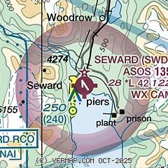
|
| Airport distance calculator |
|---|
|
|
| Sunrise and sunset |
|---|
|
Times for 07-Jun-2026
| | Local
(UTC-8) | | Zulu
(UTC) |
|---|
| Morning civil twilight | | 03:03 | | 11:03 |
| Sunrise | | 04:39 | | 12:39 |
| Sunset | | 23:15 | | 07:15 |
| Evening civil twilight | | 00:50 | | 08:50 |
|
| Current date and time |
|---|
| Zulu (UTC) | 07-Jun-2026 15:49:32 |
|---|
| Local (UTC-8) | 07-Jun-2026 07:49:32 |
|---|
|
| METAR |
|---|
| PAWD | 071453Z AUTO 00000KT 10SM -RA OVC075 07/06 A2966 RMK AO2 RAB1357E20B44 SLP043 P0000 60000 T00720061 57001 TSNO
|
|
| NOTAMs |
|---|
NOTAMs are issued by the DoD/FAA and will open in a separate window not controlled by AirNav.
|
|

