FAA INFORMATION EFFECTIVE 16 APRIL 2026
Location
| FAA Identifier: | JXI |
| Lat/Long: | 32-41-52.9150N 094-56-55.9260W
32-41.881917N 094-56.932100W
32.6980319,-94.9488683
(estimated) |
| Elevation: | 415.4 ft. / 126.6 m (surveyed) |
| Variation: | 03E (2010) |
| From city: | 2 miles S of GILMER, TX |
| Time zone: | UTC -5 (UTC -6 during Standard Time) |
| Zip code: | 75644 |
Airport Operations
| Airport use: | Open to the public |
| Activation date: | 06/1969 |
| Control tower: | no |
| ARTCC: | FORT WORTH CENTER |
| FSS: | FORT WORTH FLIGHT SERVICE STATION |
| NOTAMs facility: | JXI (NOTAM-D service available) |
| Attendance: | MON-FRI 0700-1700 |
| Wind indicator: | lighted |
| Segmented circle: | yes |
| Lights: | SS-SR |
| Beacon: | white-green (lighted land airport)
Operates sunset to sunrise. |
Airport Communications
| CTAF: | 122.9 |
| WX AWOS-3PT: | 120.250 (903-734-7313) |
| LONGVIEW APPROACH: | 124.275 |
| LONGVIEW DEPARTURE: | 124.275 |
- APCH/DEP SVC PRVDD BY FORT WORTH ARTCC (ZFW) ON FREQS 132.025/317.75 (CUMBY RCAG) WHEN LONGVIEW APCH CTL CLSD.
Nearby radio navigation aids
| VOR radial/distance | | VOR name | | Freq | | Var |
|---|
| GGGr323/19.5 | | GREGG COUNTY VORTAC | | 112.90 | | 07E |
| TYRr042/30.8 | | TYLER VOR/DME | | 114.20 | | 06E |
| NDB name | | Hdg/Dist | | Freq | | Var | | ID |
|---|
| AMBASSADOR | | 044/10.7 | | 404 | | 07E | | ABG | .- -... --. |
Airport Services
| Fuel available: | 100LL JET-A
A:FULL SVC AVBL 0830-1700, MON - FRI. |
| Parking: | hangars and tiedowns |
| Airframe service: | MAJOR |
| Powerplant service: | MAJOR |
| Bottled oxygen: | NONE |
| Bulk oxygen: | NONE |
Runway Information
Runway 18/36
| Dimensions: | 3998 x 60 ft. / 1219 x 18 m |
| Surface: | asphalt, in good condition |
| Weight bearing capacity: | |
| Runway edge lights: | medium intensity |
| RUNWAY 18 | | RUNWAY 36 |
| Latitude: | 32-42.211537N | | 32-41.552285N |
| Longitude: | 094-56.930378W | | 094-56.933825W |
| Elevation: | 415.1 ft. | | 412.6 ft. |
| Traffic pattern: | left | | left |
| Runway heading: | 177 magnetic, 180 true | | 357 magnetic, 000 true |
| Markings: | nonprecision, in good condition | | nonprecision, in good condition |
| Visual slope indicator: | 2-light PAPI on left (3.75 degrees glide path) | | |
| Touchdown point: | yes, no lights | | yes, no lights |
Airport Ownership and Management from official FAA records
| Ownership: | Publicly-owned |
| Owner: | CITY OF GILMER
110 BUFFALO STREET, P O BOX 760
GILMER, TX 75644
Phone 903-843-2552 |
| Manager: | GREG HUTSON
110 BUFFALO STREET, P O BOX 760
GILMER, TX 75644
Phone 903-843-2552
GREG HUDSON, CITY MGR, 903-843-2552. |
Additional Remarks
| A58-18 | 30 FT POLE, 70 FT DSTC, 175 FT R. |
| - | FOR CD CTC FORT WORTH ARTCC AT 817-858-7584. |
Instrument Procedures
NOTE: All procedures below are presented as PDF files. If you need a reader for these files, you should download the free Adobe Reader.NOT FOR NAVIGATION. Please procure official charts for flight.
FAA instrument procedures published for use from 16 April 2026 at 0901Z to 14 May 2026 at 0900Z.
IAPs - Instrument Approach Procedures |
|---|
| RNAV (GPS) RWY 18 | |
download (253KB) |
| RNAV (GPS) RWY 36 | |
download (207KB) |
| NOTE: Special Alternate Minimums apply | |
download (137KB) |
| NOTE: Special Take-Off Minimums/Departure Procedures apply | |
download (300KB) |
Other nearby airports with instrument procedures:
07F - Gladewater Municipal Airport (10 nm S)
F51 - Winnsboro Municipal Airport (22 nm NW)
KGGG - East Texas Regional Airport (22 nm SE)
KOSA - Mount Pleasant Regional Airport (24 nm N)
KJDD - Wood County Airport/Collins Field (28 nm W)
|
|

Road maps at:
MapQuest
Bing
Google
| Aerial photo |
|---|
WARNING: Photo may not be current or correct
 Photo by SteveÊDean
Photo taken 30-Jun-2007
looking north
Photo by SteveÊDean
Photo taken 30-Jun-2007
looking north
Do you have a better or more recent aerial photo of Fox Stephens Field/Gilmer Municipal Airport that you would like to share? If so, please send us your photo.
|
| Sectional chart |
|---|
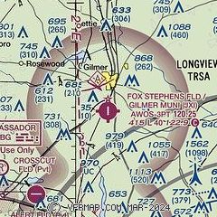
|
CAUTION: Diagram may not be current

| Airport distance calculator |
|---|
|
|
| Sunrise and sunset |
|---|
|
Times for 03-May-2026
| | Local
(UTC-5) | | Zulu
(UTC) |
|---|
| Morning civil twilight | | 06:05 | | 11:05 |
| Sunrise | | 06:32 | | 11:32 |
| Sunset | | 20:02 | | 01:02 |
| Evening civil twilight | | 20:28 | | 01:28 |
|
| Current date and time |
|---|
| Zulu (UTC) | 03-May-2026 18:39:50 |
|---|
| Local (UTC-5) | 03-May-2026 13:39:50 |
|---|
|
| METAR |
|---|
| KJXI | 031015Z AUTO 00000KT 10SM CLR 10/09 A3013 RMK AO2 T01020092
|
|
| TAF |
|---|
KGGG
22nm SE | 031740Z 0318/0418 22010G17KT P6SM SKC FM040000 20006KT P6SM SCT250 FM041500 20014G23KT P6SM SKC
|
|
| NOTAMs |
|---|
NOTAMs are issued by the DoD/FAA and will open in a separate window not controlled by AirNav.
|
|


