FAA INFORMATION EFFECTIVE 14 MAY 2026
Location
| FAA Identifier: | BIF |
| Lat/Long: | 31-50-58.3050N 106-22-48.1900W
31-50.971750N 106-22.803167W
31.8495292,-106.3800528
(estimated) |
| Elevation: | 3946.6 ft. / 1203 m (estimated) |
| Variation: | 08E (2020) |
| From city: | 5 miles NE of central business district of the associated city |
| Time zone: | UTC -6 (UTC -7 during Standard Time) |
| Zip code: | 79908 |
Airport Operations
| Airport use: | Private use. Permission required prior to landing |
| Control tower: | yes |
| ARTCC: | ALBUQUERQUE CENTER |
| FSS: | ALBUQUERQUE FLIGHT SERVICE STATION |
| NOTAMs facility: | ABQ (NOTAM-D service available) |
| Attendance: | MON-SUN 1500-0700Z++, EXCP HOL |
| Segmented circle: | no |
| Lights: | SERVICE-LGT: WHEN UNATNDD ACTVT REIL RWY 04; PAPI RWY 04 & 22; HIRL RWY 04/22 - 127.9. |
| Beacon: | white-white-green (lighted military airport)
Operates sunset to sunrise. |
| International operations: | customs landing rights airport |
Airport Communications
| BIGGS GROUND: | 121.6 251.125 [OPEN 24 HRS.] |
| BIGGS TOWER: | 127.9 342.25 [OPEN 24 HRS.] |
| EL PASO APPROACH: | 119.15 ;SOUTH-V16 124.25 ;NORTH-V16 |
| EL PASO DEPARTURE: | 124.25 |
| CLEARANCE DELIVERY: | 125.0 |
| CLASS C: | 119.15 ;SOUTH-V16 124.25 ;NORTH-V16 |
| EMERG: | 121.5 243.0 |
| IC: | 124.25 ;NORTH-V16 |
| OPS: | 134.1 ;BLISS RDO 237.2 ;BLISS RDO |
| PMSV METRO: | 373.7 |
| PTD: | 126.2 |
| WX ASOS at ELP (2.5 nm S): | PHONE 915-774-9497 |
| WX AWOS-3PT at DNA (17 nm W): | 124.175 (575-589-2643) |
- CLASS D AIRSPACE. CTC PRIOR TO ENTERING CTLZ.
- BLISS RDO OPEN 24 HRS, 134.1 237.2.
Nearby radio navigation aids
| VOR radial/distance | | VOR name | | Freq | | Var |
|---|
| ELPr280/5.4 | | EL PASO VORTAC | | 115.20 | | 12E |
| EWMr210/8.2 | | NEWMAN VORTAC | | 112.40 | | 12E |
Airport Services
Runway Information
Runway 4/22
| Dimensions: | 13554 x 150 ft. / 4131 x 46 m |
| Surface: | concrete/grooved, in good condition |
| Weight bearing capacity: | |
| Runway edge lights: | high intensity |
| RUNWAY 4 | | RUNWAY 22 |
| Latitude: | 31-50.166167N | | 31-51.777333N |
| Longitude: | 106-23.710833W | | 106-21.895500W |
| Elevation: | 3909.9 ft. | | 3946.6 ft. |
| Traffic pattern: | left | | right |
| Runway heading: | 036 magnetic, 044 true | | 216 magnetic, 224 true |
| Markings: | nonprecision, in good condition | | nonprecision, in good condition |
| Visual slope indicator: | 4-light PAPI on left (3.00 degrees glide path) | | 4-light PAPI on left (3.00 degrees glide path) |
| Approach lights: | | | SSALR: simplified short approach lighting system with runway alignment indicator lights
SSALR OTS. |
| Runway end identifier lights: | yes | | no |
| Touchdown point: | yes, no lights | | yes, no lights |
| Instrument approach: | | | ILS/DME |
Airport Ownership and Management from official FAA records
| Ownership: | U.S. Army |
| Owner: | US ARMY AERONAUTICAL SVCS AGENCY
FT BELVOIR, VA 22060 |
| Manager: | BIGGS AAF, FORT BLISS
EL PASO, TX 79901
Phone 915-744-8088 |
Additional Remarks
| E60-22 | BAK-14 BAK-12B(B) (2100'). |
| E60-04 | BAK-14 BAK-12B(B) (1500'). |
| - | RSTD: PPR ALL ACFT 24 HR PN RQRD, CTC AIRFIELD OPS DSN 621-8811/8330, C915-744-8811/8330. TWR AND SVCS AVBL FOR ALL ACFT WITH PPR. PPR TIME VALID +/-1 HR. ALL ACFT CTC AFLD OPNS VIA PTD 30 MIN PRIOR TO ARR. FLT OPS AND TRAN ALERT SVC UNAVBL BFR 1 HR PRIOR TO PPR SKED ARR. |
| - | JASU: 4(A/M32A-86) 2(A/M32-95). |
| - | SERVICE: FUEL - A+, TRUCK REFUEL ONLY (ATLANTIC AVN, 1500-0700Z++ MON-SUN, C915-779-2831, 1 HR PN, AFTER HR CALL OUT FEE $100). |
| - | FLUID: SP. |
| - | MISC: APVL RQR FOR ACCESS TO RAMP. |
| - | MISC: HGR SPACE EXTREMELY LTD FOR TRAN ACFT. |
| - | AFLD OPS OPR 1500-0700Z++ MON-SUN, EXC HOL. |
| - | TFC PAT: F/W 5000', TURBO PROP 5500', R/W 4500', JET 6000'. |
| - | MISC: KBIF AUTO OBSN AND BAAF USAF WX AVBL 24/7, DSN 621-1215/1214, C915-744-1215/1214. OT 25TH OWS, DAVIS-MONTHAN AFB, DSN 228-6598-6599. CLASS D AIRSPACE EFF 1500-0700Z++ MON-SUN, EXC HOL. OT CLASS E INTL GARBAGE CAP LTD. MUST BE BAGGED PRIOR TO ARR. |
| - | MISC: INTL GARBAGE CAP LTD. EXP DELAYS UNLESS PLACED IN GARBAGE BAGS PRIOR TO ARRIVAL. |
| - | COMMUNICATIONS: PMSV 373.7. |
| - | TWY L SOUTH OF TWY F DSGND FOR ROTARY WING ACFT ONLY. |
| - | SERVICES: NO DE-ICE AVBL, NO OFF AFLD TRNSP AVBL FOR AIRCREW, 24 HR NOTICE FOR LAV AND WATER SVCS, 915-525-7087. |
| - | CLOSED CIRCUIT TV OPNS, TSNT ACFT CIV-MIL INBD CTC AFLD OPNS VIA PTD AT 60 NM PRIOR TO LDG. |
| - | ACFT SVC/TRANS ALERT WILL NOT SUPPORT LCL, ROUND ROBIN OR OUT AND BACK FOR TRANS ACFT. |
| - | NO TWY EDGE LTS AT HOT REFUEL AREA. |
| - | WILLIAM BEAUMONT HOSPITAL HELIPAD PCL FREQ 126.2. |
| - | CAUTION: EL PASO INTL RWY 22, 2 NM SE CAN BE MISTAKEN FOR BIGGS AAF RWY 22. COYOTE HAZ. |
| - | NS ABTMT: VFR WEST ARR/DEP VIA MTN PASS 15 NM NW OF BIGGS AAF. AVOID VFR OVFT OF CITY. FLY 1500 FT AGL, 1500 FT HORIZONTAL DIST FM MTN DWELLINGS. |
| - | BEARING STRENGTH RWY 04/22: ST175 SBTT593 TRT585. |
| - | SEE FLIP AP/1 SUPPLEMENTARY ARPT RMK. |
Instrument Procedures
NOTE: All procedures below are presented as PDF files. If you need a reader for these files, you should download the free Adobe Reader.NOT FOR NAVIGATION. Please procure official charts for flight.
FAA instrument procedures published for use from 14 May 2026 at 0901Z to 11 June 2026 at 0900Z.
IAPs - Instrument Approach Procedures |
|---|
| ILS OR LOC RWY 22 | |
download (175KB) |
| RNAV (GPS) RWY 22 | |
download (141KB) |
| VOR OR TACAN RWY 22 | |
download (181KB) |
| Radar Approach Procedures available | |
download (164KB) |
| NOTE: Special Take-Off Minimums/Departure Procedures apply | |
download (299KB) |
Other nearby airports with instrument procedures:
KELP - El Paso International Airport (3 nm S)
KDNA - Dona Ana County International Jetport Airport (17 nm W)
KLRU - Las Cruces International Airport (38 nm NW)
KHMN - Holloman Air Force Base (62 nm N)
KALM - Alamogordo-White Sands Regional Airport (63 nm N)
|
|

Road maps at:
MapQuest
Bing
Google
| Aerial photo |
|---|
WARNING: Photo may not be current or correct
 Photo by Rommel S. Dorado
Photo taken 16-Jul-2006
Photo from the north looking south. The airport in the foreground if KBIF. The runway partially visible in the background (top left of the image) is runway 4/22 at KELP. Yes, the two airports are that close together.
Photo by Rommel S. Dorado
Photo taken 16-Jul-2006
Photo from the north looking south. The airport in the foreground if KBIF. The runway partially visible in the background (top left of the image) is runway 4/22 at KELP. Yes, the two airports are that close together.
Do you have a better or more recent aerial photo of Biggs Army Airfield (Fort Bliss) that you would like to share? If so, please send us your photo.
|
| Sectional chart |
|---|
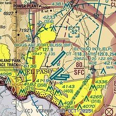
|
 Download PDF
of official airport diagram from the FAA
| Airport distance calculator |
|---|
|
|
| Sunrise and sunset |
|---|
|
Times for 22-May-2026
| | Local
(UTC-6) | | Zulu
(UTC) |
|---|
| Morning civil twilight | | 05:38 | | 11:38 |
| Sunrise | | 06:05 | | 12:05 |
| Sunset | | 19:59 | | 01:59 |
| Evening civil twilight | | 20:26 | | 02:26 |
|
| Current date and time |
|---|
| Zulu (UTC) | 22-May-2026 08:19:26 |
|---|
| Local (UTC-6) | 22-May-2026 02:19:26 |
|---|
|
| METAR |
|---|
| KBIF | 220755Z AUTO 19008KT 10SM M 20/08 A2990 RMK AO2 SLP059 T02040077 $
|
KELP
2nm S | 220751Z 16009KT 10SM FEW100 FEW130 FEW250 20/07 A2989 RMK AO2 SLP052 T02000072
|
MMCS
14nm S | 220240Z 20010KT 10SM SCT050 BKN200 24/05 A2992 RMK SLP026 54000 982 8/402
|
KDNA
17nm W | 220755Z AUTO 19007G13KT 10SM CLR 19/07 A2992 RMK AO2
|
|
| TAF |
|---|
KELP
2nm S | 220530Z 2206/2306 16010KT P6SM FEW110 SCT150 SCT250 FM221000 23008KT P6SM FEW150
|
MMCS
14nm S | 220004Z 2118/2218 21010KT P6SM VC SH SCT040CB TEMPO 2201/2203 23020KT 5SM TSRA BKN030CB FM220400 24015KT P6SM BKN200 FM220600 23010KT P6SM SKC
|
|
| NOTAMs |
|---|
NOTAMs are issued by the DoD/FAA and will open in a separate window not controlled by AirNav.
|
|


