FAA INFORMATION EFFECTIVE 14 MAY 2026
Location
| FAA Identifier: | BPT |
| Lat/Long: | 29-57-02.9920N 094-01-14.5160W
29-57.049867N 094-01.241933W
29.9508311,-94.0206989
(estimated) |
| Elevation: | 14.8 ft. / 4.5 m (surveyed) |
| Variation: | 01E (2025) |
| From city: | 9 miles SE of central business district of the associated city |
| Time zone: | UTC -5 (UTC -6 during Standard Time) |
| Zip code: | 77705 |
Airport Operations
| Airport use: | Open to the public |
| Activation date: | 04/1944 |
| Control tower: | yes |
| ARTCC: | HOUSTON CENTER |
| FSS: | MONTGOMERY COUNTY FLIGHT SERVICE STATION |
| NOTAMs facility: | BPT (NOTAM-D service available) |
| Attendance: | CONTINUOUS |
| Wind indicator: | lighted |
| Segmented circle: | yes |
| Lights: | DUSK-DAWN. WHEN ATCT CLSD REIL RWYS 16, 30 & 34; HIRL RWY 12/30 & 16/34 PRESET MED INTST. ACTVT MALSR RWY 12 - CTAF. |
| Beacon: | white-green (lighted land airport)
Operates sunset to sunrise. |
| Fire and rescue: | ARFF index A |
| International operations: | customs landing rights airport |
Airport Communications
| CTAF: | 119.5 |
| UNICOM: | 122.95 |
| ATIS: | 126.3 |
| WX ASOS: | 126.3 (409-223-4011) |
| BEAUMONT GROUND: | 124.85 [0600-2200] |
| BEAUMONT TOWER: | 119.5 [0600-2200] |
| HOUSTON APPROACH: | 121.3 |
| HOUSTON DEPARTURE: | 121.3 |
| CLEARANCE DELIVERY: | 118.3 |
| EMERG: | 121.5 243.0 |
| TRSA: | 121.3 |
| WX AWOS-3PT at BMT (12 nm NW): | 118.425 (409-866-2832) |
| WX AWOS-3 at ORG (13 nm NE): | 118.975 (409-670-9591) |
Nearby radio navigation aids
| VOR radial/distance | | VOR name | | Freq | | Var |
|---|
| SBIr356/15.9 | | SABINE PASS VOR/DME | | 115.40 | | 07E |
| DASr109/35.4 | | DAISETTA VORTAC | | 116.90 | | 05E |
| NDB name | | Hdg/Dist | | Freq | | Var | | ID |
|---|
| GOODHUE | | 119/12.2 | | 368 | | 07E | | GDE | --. -.. . |
| SULPHUR | | 240/34.5 | | 278 | | 04E | | AUR | .- ..- .-. |
Airport Services
| Fuel available: | 100LL JET-A |
| Parking: | hangars and tiedowns |
| Airframe service: | MINOR |
| Powerplant service: | MINOR |
| Bottled oxygen: | NONE |
| Bulk oxygen: | LOW |
Runway Information
Runway 12/30
| Dimensions: | 6751 x 150 ft. / 2058 x 46 m |
| Surface: | concrete/grooved, in fair condition |
| Weight bearing capacity: | | Single wheel: | 90.0 | | Double wheel: | 170.0 | | Double tandem: | 230.0 |
|
| Runway edge lights: | high intensity |
| RUNWAY 12 | | RUNWAY 30 |
| Latitude: | 29-57.318577N | | 29-56.745617N |
| Longitude: | 094-01.667847W | | 094-00.571195W |
| Elevation: | 14.4 ft. | | 5.8 ft. |
| Traffic pattern: | left | | left |
| Runway heading: | 120 magnetic, 121 true | | 300 magnetic, 301 true |
| Declared distances: | TORA:6751 TODA:6751 ASDA:6508 LDA:6508 | | TORA:6751 TODA:6751 ASDA:6751 LDA:6751 |
| Markings: | precision, in good condition | | precision, in good condition |
| Visual slope indicator: | | | 4-box VASI on left (3.00 degrees glide path) |
| RVR equipment: | touchdown | | rollout |
| Approach lights: | MALSR: 1,400 foot medium intensity approach lighting system with runway alignment indicator lights | | |
| Runway end identifier lights: | | | yes |
| Touchdown point: | yes, no lights | | yes, no lights |
| Instrument approach: | ILS/DME | | |
| Obstructions: | 46 ft. tree, 1041 ft. from runway, 618 ft. right of centerline, 18:1 slope to clear | | 41 ft. tree, 1024 ft. from runway, 529 ft. right of centerline, 20:1 slope to clear |
Runway 16/34
| Dimensions: | 5071 x 150 ft. / 1546 x 46 m |
| Surface: | asphalt/concrete/grooved, in fair condition
FIRST 4271 FT OF RWY 34 GRVD. |
| Weight bearing capacity: | | Single wheel: | 70.0 | | Double wheel: | 90.0 | | Double tandem: | 145.0 |
|
| Runway edge lights: | high intensity |
| RUNWAY 16 | | RUNWAY 34 |
| Latitude: | 29-57.479285N | | 29-56.667688N |
| Longitude: | 094-01.521467W | | 094-01.288412W |
| Elevation: | 14.4 ft. | | 10.9 ft. |
| Traffic pattern: | left | | left |
| Runway heading: | 165 magnetic, 166 true | | 345 magnetic, 346 true |
| Declared distances: | TORA:5070 TODA:5070 ASDA:5070 LDA:5070 | | TORA:5070 TODA:5070 ASDA:5070 LDA:5070 |
| Markings: | nonprecision, in good condition | | nonprecision, in good condition |
| Visual slope indicator: | 4-light PAPI on right (3.00 degrees glide path) | | 4-box VASI on left (3.00 degrees glide path) |
| Runway end identifier lights: | yes | | yes |
| Touchdown point: | yes, no lights | | yes, no lights |
Airport Ownership and Management from official FAA records
| Ownership: | Publicly-owned |
| Owner: | JEFFERSON COUNTY
1149 PEARL ST 4TH FLOOR
BEAUMONT, TX 77701
Phone 409-835-8466 |
| Manager: | ALEX RUPP
5000 JERRY WARE DR SUITE 100
BEAUMONT, TX 77705
Phone 409-719-4900 |
Additional Remarks
| A39-12/30 | PCR VALUE: 578/R/C/W/T |
| A39-16/34 | PCR VALUE: 172/R/D/W/T |
| - | BIRD ACTVTY ON & INVOF ARPT. |
| - | FOR CD WHEN ATCT IS CLSD CTC HOUSTON APCH AT 281-443-5844 TO CNL IFR AT 281-443-5888. |
Instrument Procedures
NOTE: All procedures below are presented as PDF files. If you need a reader for these files, you should download the free Adobe Reader.NOT FOR NAVIGATION. Please procure official charts for flight.
FAA instrument procedures published for use from 14 May 2026 at 0901Z to 11 June 2026 at 0900Z.
IAPs - Instrument Approach Procedures |
|---|
| ILS OR LOC RWY 12 | |
download (337KB) |
| RNAV (GPS) RWY 12 | |
download (276KB) |
| RNAV (GPS) RWY 16 | |
download (243KB) |
| RNAV (GPS) RWY 30 | |
download (257KB) |
| RNAV (GPS) RWY 34 | |
download (231KB) |
| NOTE: Special Alternate Minimums apply | |
download (147KB) |
| NOTE: Special Take-Off Minimums/Departure Procedures apply | |
download (70KB) |
Other nearby airports with instrument procedures:
KBMT - Beaumont Municipal Airport (12 nm NW)
KORG - Orange County Airport (13 nm NE)
T90 - Chambers County/Winnie Stowell Airport (23 nm W)
45R - Hawthorne Field Airport (26 nm NW)
T00 - Chambers County Airport (35 nm W)
|
|

Road maps at:
MapQuest
Bing
Google
| Aerial photo |
|---|
WARNING: Photo may not be current or correct
 Photo by HS
Photo taken 22-Feb-2009
Photo by HS
Photo taken 22-Feb-2009
Do you have a better or more recent aerial photo of Jack Brooks Regional Airport that you would like to share? If so, please send us your photo.
|
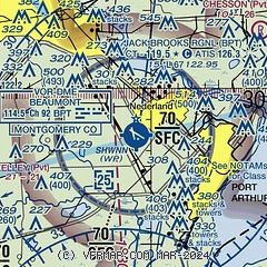
| Sectional chart |
|---|
|
 Download PDF
of official airport diagram from the FAA
| Airport distance calculator |
|---|
|
|
| Sunrise and sunset |
|---|
|
Times for 05-Jun-2026
| | Local
(UTC-5) | | Zulu
(UTC) |
|---|
| Morning civil twilight | | 05:49 | | 10:49 |
| Sunrise | | 06:16 | | 11:16 |
| Sunset | | 20:13 | | 01:13 |
| Evening civil twilight | | 20:40 | | 01:40 |
|
| Current date and time |
|---|
| Zulu (UTC) | 05-Jun-2026 10:32:43 |
|---|
| Local (UTC-5) | 05-Jun-2026 05:32:43 |
|---|
|
| METAR |
|---|
| KBPT | 051019Z 11011KT 10SM SCT016 SCT022 24/22 A2992 RMK AO2 T02390222
|
KBMT
12nm NW | 051015Z AUTO 10005KT 10SM BKN015 OVC022 23/21 A2993 RMK AO2 T02280205
|
KORG
13nm NE | 051015Z AUTO 08005KT 10SM SCT014 SCT065 23/21 A2996 RMK AO2 T02260210
|
|
| TAF |
|---|
| KBPT | 050520Z 0506/0606 10010KT P6SM VCSH SCT025 BKN050 TEMPO 0506/0510 6SM -SHRA BR BKN025 FM051100 10011KT P6SM BKN025 FM051800 11011G16KT P6SM VCSH SCT050 BKN120 FM060100 09005KT P6SM BKN050
|
|
| NOTAMs |
|---|
NOTAMs are issued by the DoD/FAA and will open in a separate window not controlled by AirNav.
|
|


