FAA INFORMATION EFFECTIVE 14 MAY 2026
Location
| FAA Identifier: | CJJ |
| Lat/Long: | 43-21-55.0850N 092-07-59.0990W
43-21.918083N 092-07.984983W
43.3653014,-92.1330831
(estimated) |
| Elevation: | 1279 ft. / 389.8 m (surveyed) |
| Variation: | 02E (1985) |
| From city: | 1 mile SW of CRESCO, IA |
| Time zone: | UTC -5 (UTC -6 during Standard Time) |
| Zip code: | 52136 |
Airport Operations
| Airport use: | Open to the public |
| Activation date: | 06/1963 |
| Control tower: | no |
| ARTCC: | MINNEAPOLIS CENTER |
| FSS: | FORT DODGE FLIGHT SERVICE STATION |
| NOTAMs facility: | FOD (NOTAM-D service available) |
| Attendance: | UNATNDD |
| Wind indicator: | lighted |
| Segmented circle: | no |
| Lights: | ACTVT LIRL RWY 15/33 - 122.7. |
Airport Communications
| CTAF/UNICOM: | 122.8 |
| WX AWOS-3 at DEH (18 nm E): | 118.400 (563-382-2990) |
| WX AWOS-3PT at FKA (19 nm N): | 118.550 (507-765-2182) |
- ANSWERED BY POLICE; NOT ON FIELD.
- APCH/DEP SVC PRVDD BY MINNAEPOLIS ARTCC ON FREQ 118.85 (LA CROSSE RCAG).
Nearby radio navigation aids
| VOR radial/distance | | VOR name | | Freq | | Var |
|---|
| RSTr136/32.2 | | ROCHESTER VOR/DME | | 112.00 | | 05E |
Airport Services
| Oil available: | CTAF/UNICOM OTS INDEFLY. |
| Parking: | tiedowns |
| Airframe service: | NONE |
| Powerplant service: | NONE |
| Bottled oxygen: | NONE |
| Bulk oxygen: | NONE |
Runway Information
Runway 15/33
| Dimensions: | 2949 x 50 ft. / 899 x 15 m |
| Surface: | concrete, in fair condition |
| Weight bearing capacity: | |
| Runway edge lights: | low intensity |
| RUNWAY 15 | | RUNWAY 33 |
| Latitude: | 43-22.136017N | | 43-21.699233N |
| Longitude: | 092-08.129617W | | 092-07.839467W |
| Elevation: | 1279.0 ft. | | 1265.0 ft. |
| Traffic pattern: | left | | left |
| Runway heading: | 152 magnetic, 154 true | | 332 magnetic, 334 true |
| Markings: | nonprecision, in fair condition | | nonprecision, in fair condition |
| Touchdown point: | yes, no lights | | yes, no lights |
| Obstructions: | 74 ft. tree, 1736 ft. from runway, 86 ft. left of centerline, 20:1 slope to clear | | 25 ft. pole, 714 ft. from runway, 228 ft. left of centerline, 20:1 slope to clear |
Airport Ownership and Management from official FAA records
| Ownership: | Publicly-owned |
| Owner: | CITY OF CRESCO
130 NORTH PARK PLACE
CRESCO, IA 52136
Phone 319-547-3101 |
| Manager: | CLAIR PECINOVSKY
12848 WELL ROAD
CRESCO, IA 52136
Phone 563-547-4898 |
Additional Remarks
| - | BE ALERT FOR ULTRALIGHT ACTIVITY ON & INVOF ARPT. |
| - | FOR CD CTC ROCHESTER APCH AT 507-424-8111. FOR CD WHEN ROCHESTER APCH IS CLOSED, CTC MINNEAPOLIS ARTCC AT 651-463-5588. |
| - | SNOW REMOVAL DELAYED AT TIMES; CONFIRM RWY CONDITIONS PRIOR TO USE: CALL 563-547-4898 OR AMGR, 563-379-5898. |
Instrument Procedures
NOTE: All procedures below are presented as PDF files. If you need a reader for these files, you should download the free Adobe Reader.NOT FOR NAVIGATION. Please procure official charts for flight.
FAA instrument procedures published for use from 14 May 2026 at 0901Z to 11 June 2026 at 0900z.
IAPs - Instrument Approach Procedures |
|---|
| GPS RWY 15 **CHANGED** | |
download (161KB) |
| GPS RWY 33 **CHANGED** | |
download (157KB) |
| NOTE: Special Take-Off Minimums/Departure Procedures apply | |
download (427KB) |
Other nearby airports with instrument procedures:
KDEH - Decorah Municipal Airport (18 nm E)
KFKA - Fillmore County Airport (19 nm N)
KCCY - Northeast Iowa Regional Airport (27 nm SW)
3Y2 - George L Scott Municipal Airport (27 nm SE)
55Y - Rushford Municipal Airport/Robert W Bunke Field (30 nm NE)
|
|

Road maps at:
MapQuest
Bing
Google
| Aerial photo |
|---|
WARNING: Photo may not be current or correct
 Photo taken 27-Aug-2006
Do you have a better or more recent aerial photo of Ellen Church Field Airport that you would like to share? If so, please send us your photo.
|
| Sectional chart |
|---|
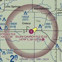
|
| Airport distance calculator |
|---|
|
|
| Sunrise and sunset |
|---|
|
Times for 14-May-2026
| | Local
(UTC-5) | | Zulu
(UTC) |
|---|
| Morning civil twilight | | 05:13 | | 10:13 |
| Sunrise | | 05:46 | | 10:46 |
| Sunset | | 20:24 | | 01:24 |
| Evening civil twilight | | 20:56 | | 01:56 |
|
| Current date and time |
|---|
| Zulu (UTC) | 14-May-2026 20:11:36 |
|---|
| Local (UTC-5) | 14-May-2026 15:11:36 |
|---|
|
| METAR |
|---|
KDEH
19nm E | 141955Z AUTO 19008G17KT 150V240 10SM CLR 24/03 A2991 RMK AO2
|
KFKA
19nm N | 141955Z AUTO 17014G23KT 10SM CLR 24/02 A2988 RMK AO2 LTG DSNT SW-NW
|
KCCY
28nm SW | 141955Z AUTO 14018G24KT 10SM CLR 25/01 A2988 RMK AO2
|
KRST
36nm NW | 141954Z 17017G27KT 10SM CLR 24/02 A2986 RMK AO2 PK WND 14032/1934 SLP111 T02440017
|
|
| TAF |
|---|
KRST
36nm NW | 141720Z 1418/1518 18018G28KT P6SM FEW250 FM150000 17015G25KT 6SM -SHRA OVC070 FM150300 16013G22KT P6SM OVC080 FM150900 21014G22KT P6SM FEW100
|
|
| NOTAMs |
|---|
NOTAMs are issued by the DoD/FAA and will open in a separate window not controlled by AirNav.
|
|

