FAA INFORMATION EFFECTIVE 14 MAY 2026
Location
| FAA Identifier: | HRX |
| Lat/Long: | 34-51-38.5160N 102-19-33.1797W
34-51.641933N 102-19.552995W
34.8606989,-102.3258832
(estimated) |
| Elevation: | 3787.6 ft. / 1154.5 m (surveyed) |
| Variation: | 09E (1995) |
| From city: | 4 miles NE of HEREFORD, TX |
| Time zone: | UTC -5 (UTC -6 during Standard Time) |
| Zip code: | 79045 |
Airport Operations
| Airport use: | Open to the public |
| Activation date: | 08/1958 |
| Control tower: | no |
| ARTCC: | ALBUQUERQUE CENTER |
| FSS: | FORT WORTH FLIGHT SERVICE STATION |
| NOTAMs facility: | FTW (NOTAM-D service available) |
| Attendance: | 0800-1700 |
| Wind indicator: | lighted |
| Segmented circle: | yes |
| Lights: | MIRL RWY 02/20 PRESET LOW INTST SS-SR. TO ACTVT MIRL 02/20 OR INCR INTST - CTAF. PAPI RWY 02 & 20 OPR CONSLY. |
| Beacon: | white-green (lighted land airport)
Operates sunset to sunrise. |
Airport Communications
| CTAF/UNICOM: | 122.8 |
| WX AWOS-3: | 118.05 (806-258-7283) |
| AMARILLO APPROACH: | 119.5 |
| ALBUQUERQUE ARTCC APPROACH: | 121.15 |
| AMARILLO DEPARTURE: | 119.5 |
| ALBUQUERQUE ARTCC DEPARTURE: | 121.15 |
- APCH/DEP SVC PRVDD BY ALBUQUERQUE ARTCC (ZAB) ON FREQS 127.85/285.475 (AMARILLO RCAG) WHEN AMARILLO APCH CTL (AMA) CLSD.
Nearby radio navigation aids
| VOR radial/distance | | VOR name | | Freq | | Var |
|---|
| TXOr038/33.5 | | TEXICO VORTAC | | 112.20 | | 11E |
| PNHr226/38.1 | | PANHANDLE VORTAC | | 116.60 | | 08E |
Airport Services
| Fuel available: | 100LL JET-A
100LL:24 HRS SELF-SERVE. |
| Parking: | hangars and tiedowns |
| Airframe service: | MAJOR |
| Powerplant service: | MAJOR |
| Bottled oxygen: | NONE |
| Bulk oxygen: | NONE |
Runway Information
Runway 2/20
| Dimensions: | 6100 x 100 ft. / 1859 x 30 m |
| Surface: | concrete/grooved, in excellent condition |
| Runway edge lights: | medium intensity |
| RUNWAY 2 | | RUNWAY 20 |
| Latitude: | 34-51.324275N | | 34-52.205020N |
| Longitude: | 102-19.758557W | | 102-19.169717W |
| Elevation: | 3786.2 ft. | | 3786.2 ft. |
| Traffic pattern: | left | | left |
| Runway heading: | 020 magnetic, 029 true | | 200 magnetic, 209 true |
| Markings: | nonprecision, in good condition | | nonprecision, in good condition |
| Visual slope indicator: | 4-light PAPI on left (3.00 degrees glide path) | | 4-light PAPI on left (3.00 degrees glide path) |
| Touchdown point: | yes, no lights | | yes, no lights |
| Obstructions: | 45 ft. pline, 2335 ft. from runway, 596 ft. left of centerline, 47:1 slope to clear | | none |
Runway 14/32
| Dimensions: | 3807 x 135 ft. / 1160 x 41 m |
| Surface: | turf, in fair condition |
| Runway edge markings: | THR MKD WITH 10 X 60 FT CONCRETE PAD ACRS END. |
| RUNWAY 14 | | RUNWAY 32 |
| Latitude: | 34-51.720300N | | 34-51.170317N |
| Longitude: | 102-19.878717W | | 102-19.512033W |
| Elevation: | 3783.0 ft. | | 3783.0 ft. |
| Traffic pattern: | left | | left |
| Runway heading: | 142 magnetic, 151 true | | 322 magnetic, 331 true |
| Markings: | none, in fair condition | | none, in fair condition |
| Touchdown point: | yes, no lights | | yes, no lights |
| Obstructions: | 50 ft. pline, 1400 ft. from runway, 280 ft. right of centerline, 28:1 slope to clear | | 50 ft. pline, 1200 ft. from runway, 24:1 slope to clear |
Airport Ownership and Management from official FAA records
| Ownership: | Publicly-owned |
| Owner: | CITY OF HEREFORD
BOX 2277
HEREFORD, TX 79045
Phone 806-363-7100 |
| Manager: | CAYDEN FINCH
4175 US HWY 60
HEREFORD, TX 79045
Phone 806-344-7710 |
Additional Remarks
| - | FOR CD CTC ALBUQUERQUE ARTCC AT 505-856-4861. |
Instrument Procedures
NOTE: All procedures below are presented as PDF files. If you need a reader for these files, you should download the free Adobe Reader.NOT FOR NAVIGATION. Please procure official charts for flight.
FAA instrument procedures published for use from 14 May 2026 at 0901Z to 11 June 2026 at 0900Z.
IAPs - Instrument Approach Procedures |
|---|
| RNAV (GPS) RWY 02 | |
download (269KB) |
| RNAV (GPS) RWY 20 | |
download (236KB) |
| NOTE: Special Alternate Minimums apply | |
download (20KB) |
| NOTE: Special Take-Off Minimums/Departure Procedures apply | |
download (113KB) |
Other nearby airports with instrument procedures:
KTDW - Tradewind Airport (31 nm NE)
KAMA - Rick Husband Amarillo International Airport (37 nm NE)
2T1 - Muleshoe Municipal Airport (43 nm S)
KCVN - Clovis Regional Airport (45 nm SW)
KPVW - Hale County Airport (51 nm SE)
|
|

Road maps at:
MapQuest
Bing
Google
| Aerial photo |
|---|
WARNING: Photo may not be current or correct

Do you have a better or more recent aerial photo of Hereford Municipal Airport that you would like to share? If so, please send us your photo.
|
| Sectional chart |
|---|
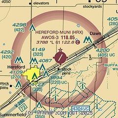
|
| Airport distance calculator |
|---|
|
|
| Sunrise and sunset |
|---|
|
Times for 07-Jun-2026
| | Local
(UTC-5) | | Zulu
(UTC) |
|---|
| Morning civil twilight | | 06:07 | | 11:07 |
| Sunrise | | 06:36 | | 11:36 |
| Sunset | | 21:00 | | 02:00 |
| Evening civil twilight | | 21:29 | | 02:29 |
|
| Current date and time |
|---|
| Zulu (UTC) | 07-Jun-2026 05:20:22 |
|---|
| Local (UTC-5) | 07-Jun-2026 00:20:22 |
|---|
|
| METAR |
|---|
| KHRX | 070455Z AUTO 14006KT 10SM CLR 18/16 A2986 RMK AO2 T01750158 TSNO
|
|
| TAF |
|---|
KAMA
37nm NE | 070026Z 0700/0724 17008KT P6SM BKN090 TEMPO 0700/0702 3SM -TSRA OVC050CB FM070300 15008KT P6SM BKN100 FM071100 18008KT P6SM FEW025 FM071500 20010KT P6SM SKC
|
|
| NOTAMs |
|---|
NOTAMs are issued by the DoD/FAA and will open in a separate window not controlled by AirNav.
|
|


