FAA INFORMATION EFFECTIVE 16 APRIL 2026
Location
| FAA Identifier: | CZT |
| Lat/Long: | 28-31-20.1000N 099-49-25.1000W
28-31.335000N 099-49.418333W
28.5222500,-99.8236389
(estimated) |
| Elevation: | 598.1 ft. / 182.3 m (surveyed) |
| Variation: | 07E (2000) |
| From city: | 2 miles E of CARRIZO SPRINGS, TX |
| Time zone: | UTC -5 (UTC -6 during Standard Time) |
| Zip code: | 78834 |
Airport Operations
| Airport use: | Open to the public |
| Activation date: | 06/1945 |
| Control tower: | no |
| ARTCC: | HOUSTON CENTER |
| FSS: | SAN ANGELO FLIGHT SERVICE STATION |
| NOTAMs facility: | CZT (NOTAM-D service available) |
| Attendance: | 0800 - 1700 |
| Wind indicator: | lighted |
| Segmented circle: | yes |
| Lights: | SS-SR |
| Beacon: | white-green (lighted land airport)
Operates sunset to sunrise. |
| Landing fee: | yes |
Airport Communications
| CTAF/UNICOM: | 122.8 |
| WX AWOS-3: | 119.625 (830-876-9243) |
- APCH/DEP CTL SVC PRVDD BY HOUSTON ARTCC (ZHU) ON FREQS 127.8/307.2 (UVALDE RCAG).
Nearby radio navigation aids
| VOR radial/distance | | VOR name | | Freq | | Var |
|---|
| COTr267/37.4 | | COTULLA VORTAC | | 115.80 | | 09E |
Airport Services
| Fuel available: | 100LL JET-A+
100LL:FUEL AVBL ON REQ 830-876-2967. |
| Parking: | hangars and tiedowns |
| Bottled oxygen: | NONE |
| Bulk oxygen: | NONE |
Runway Information
Runway 13/31
| Dimensions: | 5003 x 75 ft. / 1525 x 23 m |
| Surface: | asphalt, in excellent condition |
| Weight bearing capacity: | |
| Runway edge lights: | medium intensity |
| RUNWAY 13 | | RUNWAY 31 |
| Latitude: | 28-31.621977N | | 28-31.048780N |
| Longitude: | 099-49.754780W | | 099-49.082157W |
| Elevation: | 598.1 ft. | | 582.7 ft. |
| Traffic pattern: | left | | left |
| Runway heading: | 127 magnetic, 134 true | | 307 magnetic, 314 true |
| Markings: | nonprecision, in good condition | | nonprecision, in good condition |
| Visual slope indicator: | 4-light PAPI on left (3.00 degrees glide path) | | 4-light PAPI on left (3.00 degrees glide path) |
| Touchdown point: | yes, no lights | | yes, no lights |
| Obstructions: | 35 ft. pline, 640 ft. from runway, 188 ft. left of centerline, 12:1 slope to clear | | 42 ft. pole, 1340 ft. from runway, 180 ft. right of centerline, 27:1 slope to clear |
Airport Ownership and Management from official FAA records
| Ownership: | Publicly-owned |
| Owner: | DIMMIT COUNTY
DIMMIT CO COURTHOUSE
CARRIZO SPRINGS, TX 78834
Phone 830-876-2323 |
| Manager: | ERNEST MARTINEZ, JR
PO BOX 432
CARRIZO SPRINGS, TX 78834
Phone 830-876-2967 |
Additional Remarks
| - | DEER ON OR INVOF ARPT |
| - | FOR CD CTC HOUSTON ARTCC AT 281-230-5622. |
| - | RWY 31, UNMKD, UNLGTD ELECT TRANSMISSION LINES UNDERLIE APCH. |
Instrument Procedures
NOTE: All procedures below are presented as PDF files. If you need a reader for these files, you should download the free Adobe Reader.NOT FOR NAVIGATION. Please procure official charts for flight.
FAA instrument procedures published for use from 16 April 2026 at 0901Z to 14 May 2026 at 0900Z.
IAPs - Instrument Approach Procedures |
|---|
| RNAV (GPS) RWY 13 | |
download (208KB) |
| RNAV (GPS) RWY 31 | |
download (215KB) |
| NOTE: Special Take-Off Minimums/Departure Procedures apply | |
download (293KB) |
Other nearby airports with instrument procedures:
KCOT - Cotulla-La Salle County Airport (32 nm E)
5T9 - Maverick County Memorial International Airport (41 nm NW)
KUVA - Garner Field Airport (42 nm N)
T30 - Mc Kinley Field Airport (42 nm NE)
23R - Devine Municipal Airport (59 nm NE)
|
|

Road maps at:
MapQuest
Bing
Google
| Aerial photo |
|---|
WARNING: Photo may not be current or correct
 Photo taken 30-Aug-2005
from the south from about 10,500ft
Photo taken 30-Aug-2005
from the south from about 10,500ft
Do you have a better or more recent aerial photo of Dimmit County Airport that you would like to share? If so, please send us your photo.
|
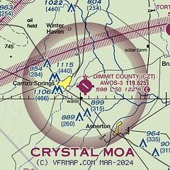
| Sectional chart |
|---|
|
| Airport distance calculator |
|---|
|
|
| Sunrise and sunset |
|---|
|
Times for 18-Apr-2026
| | Local
(UTC-5) | | Zulu
(UTC) |
|---|
| Morning civil twilight | | 06:47 | | 11:47 |
| Sunrise | | 07:12 | | 12:12 |
| Sunset | | 20:06 | | 01:06 |
| Evening civil twilight | | 20:30 | | 01:30 |
|
| Current date and time |
|---|
| Zulu (UTC) | 18-Apr-2026 22:11:57 |
|---|
| Local (UTC-5) | 18-Apr-2026 17:11:57 |
|---|
|
| METAR |
|---|
| KCZT | 119.625
182155Z AUTO 36010G19KT 7SM 13/13 A3008 RMK AO2 P0001
|
|
| TAF |
|---|
KCOT
32nm E | 181945Z 1820/1918 02020G28KT P6SM VCSH SCT015 OVC040 FM190400 02013KT 5SM -RA BKN009 OVC015 TEMPO 1904/1906 2SM RA BKN007 FM190600 36012KT 4SM -RA -DZ BKN009 OVC015 PROB30 1906/1912 2SM RA OVC007
|
MMPG
38nm W | 181733Z 1818/1918 31015G25KT 1SM RA BR OVC008 TEMPO 1818/1822 1/2SM FG VV006 FM182300 34013G28KT 1SM BR RA OVC008 FM190200 02008KT 4SM HZ BKN020 FM191200 03005KT P6SM BKN030
|
|
| NOTAMs |
|---|
NOTAMs are issued by the DoD/FAA and will open in a separate window not controlled by AirNav.
|
|

