FAA INFORMATION EFFECTIVE 16 APRIL 2026
Location
| FAA Identifier: | DMA |
| Lat/Long: | 32-09-58.9119N 110-52-59.4109W
32-09.981865N 110-52.990182W
32.1663644,-110.8831697
(estimated) |
| Elevation: | 2704 ft. / 824 m (estimated) |
| Variation: | 09E (2025) |
| From city: | 2 miles SW of TUCSON, AZ |
| Time zone: | UTC -7 (year round; does not observe DST) |
| Zip code: | 85708 |
Airport Operations
| Airport use: | Private use. Permission required prior to landing |
| Activation date: | 04/1940 |
| Control tower: | yes |
| ARTCC: | ALBUQUERQUE CENTER |
| FSS: | PRESCOTT FLIGHT SERVICE STATION |
| NOTAMs facility: | PRC (NOTAM-D service available) |
| Attendance: | |
| Pattern altitude: | CONVL 3700 FT; OVERHEAD 5000 FT UNTIL 4 DME THEN 4200 FT. NO OVERHEAD TFC PAT AUTH EXC TO PERM BASE ASGN ACFT SS-SR. MAX SPEED IN OVERHEAD PAT IS 300 KIAS. DO NOT EXCEED 3700 FT TIL DEP END OF RWY. |
| Wind indicator: | yes |
| Segmented circle: | no |
| Beacon: | white-green (lighted land airport)
Operates sunset to sunrise. |
| International operations: | international airport of entry |
Airport Communications
| ATIS: | 270.1 |
| D-M GROUND: | 121.8 275.8 [M-F 1200-0700Z; WKEND, HOL, AND ACC DOWN DAYS 1500-0000Z.] |
| D-M TOWER: | 118.85 253.5 [M-F 1200-0700Z; WKEND, HOL, AND ACC DOWN DAYS 1500-0000Z.] |
| TUCSON APPROACH: | 119.4 ;RWY 13 286-089 TUS 119.4 ;RWY 31 066-274 TUS 125.1 ; RWY 31 275-065 TUS 125.1 ;RWY 13, 090-285 TUS 128.5 |
| TUCSON DEPARTURE: | 119.4 ;RWY 13 286-089 TUS 119.4 ;RWY 31 066-274 TUS 125.1 ; RWY 31 275-065 TUS 125.1 ;RWY 13, 090-285 TUS 128.5 |
| CLEARANCE DELIVERY: | 121.8 275.8 |
| CLASS C: | 119.4 ;RWY 13, 286-089 TUS 119.4 ;RWY 31, 066-274 TUS 125.1 ;RWY 13, 090-285 TUS 125.1 ;RWY 31 090-285 TUS |
| COMD POST: | 296.3 304.8 381.3 |
| PMSV METRO: | 239.8 |
| PTD: | 372.2 |
| WX ASOS at TUS (4 nm SW): | PHONE 520-355-5542 |
| WX AWOS-3 at RYN (15 nm W): | PHONE 520-578-0269 |
- PAR AVBL DURG DALGT VFR ONLY 0900-1700 WKDAYS; CLSD SAT/SUN & HOL.
- PMSV METRO: ALT PMSV METRO KLUF 267.4.
- CALL RAYMOND 8.
Nearby radio navigation aids
| VOR radial/distance | | VOR name | | Freq | | Var |
|---|
| TUSr009/4.6 | | TUCSON VORTAC | | 116.00 | | 12E |
| NDB name | | Hdg/Dist | | Freq | | Var | | ID |
|---|
| RYAN | | 071/14.2 | | 338 | | 12E | | RYN | .-. -.-- -. |
| ROBLES | | 065/24.9 | | 220 | | 12E | | RBJ | .-. -... .--- |
Airport Services
| Fuel available: | A++
A++:TSNT EXP UP TO 2 HR DLA; DV CTC PTD -30 MIN PRIOR - 372.2. |
| Parking: | hangars and tiedowns |
| Airframe service: | MAJOR |
| Powerplant service: | MAJOR |
| Bottled oxygen: | HIGH/LOW |
| Bulk oxygen: | HIGH/LOW |
Runway Information
Runway 13/31
| Dimensions: | 13645 x 200 ft. / 4159 x 61 m
FIRST 2700 FT RWY 13 & FIRST 2445 FT RWY 31 CONC; MID 8500 FT ASPH. |
| Surface: | PEM |
| Weight bearing capacity: | |
| Runway edge lights: | high intensity |
| Operational restrictions: | BEARING STRENGTH S155 T210 ST175 TT345. ASSAULT LDG ZONE MARK 2000 FT FM THR. STD ACC RSRS APPLIED EXC 6000 FT BTN C130 ACFT. |
| RUNWAY 13 | | RUNWAY 31 |
| Latitude: | 32-10.810000N | | 32-09.153667N |
| Longitude: | 110-53.885500W | | 110-52.095000W |
| Elevation: | 2588.7 ft. | | 2703.9 ft. |
| Traffic pattern: | left | | right |
| Runway heading: | 128 magnetic, 137 true | | 308 magnetic, 317 true |
| Markings: | precision | | precision |
| Visual slope indicator: | 4-light PAPI on left (3.00 degrees glide path) | | 4-light PAPI on left (3.00 degrees glide path) |
| RVR equipment: | touchdown | | touchdown |
| Approach lights: | | | ALSF1: standard 2,400 foot high intensity approach lighting system with centerline sequenced flashers (category I) |
| Runway end identifier lights: | yes | | no |
| Touchdown point: | yes, no lights | | yes, no lights |
| Instrument approach: | LOC/GS | | ILS |
Airport Ownership and Management from official FAA records
| Ownership: | U.S. Air Force |
| Owner: | USAF
2400 VALLEY BANK BLDG
PHOENIX, AZ 85083
Phone 602-261-4774 |
| Manager: | BASE OPERATIONS
DAVIS-MONTHAN AFB
TUCSON, AZ 85707
Phone 520-228-4710
TUCSON APCH CTL - 520-228-4507/4315. |
Additional Remarks
| E60-13 | HOOK BAK-12A(B) (125 FT OVRN) HOOK BAK-12A(B)(1200 FT). |
| E60-31 | HOOK BAK-12A(B)(1198 FT) HOOK BAK-12A(B) (70 FT OVRN). |
| - | NOISE ABATMENT PROC IN EFCT: QUIET HR 0530-1300Z EXC 7 DAY PPR. MAX CLIMB NA. DISC AFT BURNER SAFELY ASAP. HVY EXP RWY 13 DEP. |
| - | CTN: WILDLIFE INVOF OF RWY; SPCLY JUN-AUG. |
| - | FLUID: SP PRESAIR LHOX LOX |
| - | OIL: O-148-156 JOAP; W-72 HR PN RQR |
| - | A-GEAR: ALL BAK-12A EXTN. |
| - | RSTD: DV CODE 6 OR ABV & SPACE A PAX - PTD 30 MIN PRIOR TO ARR FOR BLOCK TIME. |
| - | RSTD: 24 HR - 3 WEEK PPR BFR ARR - D228-4315/4507/C520-228-4315/6058 OR 563OSS.OSAA.ORGBOX@US.AF.MIL; NO V/STOL APCH LDG. |
| - | CTN: HI ALT WX BALLOON RELEASE 1100Z & 2300Z DLY; 5 MI FNL RWY 13. |
| - | RSTD: TSNT PMTD 1 APCH TO FSL; IF DAVIS MONTHAN NOT FINAL DESTN 1 APCH & DEP PAT; MULTI APCH PPR - ROG/CC. |
| - | RSTD: AIR FLD CLSD 1300-2100Z LAST SAT MONTH. |
| - | MISC: ATC COOPERATIVE WX WATCH; INCLS ATCT & SCTR VIS & PIREPS. |
| - | MISC: BASE WX H24 - DSN 228-6014/3254; 2 HR PRIOR NOTICE RQR FOR TIMELY BRIEF. FMQ-19 AUTOMATED WX OBS H24; CLSD WKEND & FED HOL - D228-6014/3254; FAX D228-3255. |
| - | MISC: 25 OWS WX H24 - D228-6598/6599. 2 HR NOTICE RQR FOR TIMELY BRIEF. |
| - | CTN: BASH-PHASE II BIRD ACT MIGRATORY SEASON 1 MAY - 30 SEP. |
| - | TRAN ALERT: FLEET SVC MON-FRI 1400-0000Z WITH 24 HR PPR; AFT HR, WKEND, HOL & TDY RQR CREDIT CARD PRIOR - TRAN ALERT D228-4292/C520-228-4292. |
| - | MISC: TWY C BTW TXL BRAVO & TWY DELTA LTD TO WINGSPAN 60 FT OR LESS. |
| - | FOR CD WHEN ATCT IS CLSD CTC TUCSON APCH AT 520-829-6121. |
| - | MOWER OPS SR-SS; 01 MAR - 31 OCT. |
| - | TSNT CLASSIFIED MATERIAL UP TO SECRET STORAGE - WG COMD POST; TOP SECRET STORAGE - 228-5987. |
| - | PMSV METRO O/S UFN. |
Instrument Procedures
NOTE: All procedures below are presented as PDF files. If you need a reader for these files, you should download the free Adobe Reader.NOT FOR NAVIGATION. Please procure official charts for flight.
FAA instrument procedures published for use from 16 April 2026 at 0901Z to 14 May 2026 at 0900Z.
IAPs - Instrument Approach Procedures |
|---|
| HI-ILS OR LOC Z RWY 13 | |
download (501KB) |
| HI-ILS OR LOC Z RWY 31 | |
download (466KB) |
| ILS OR LOC Y RWY 13 | |
download (505KB) |
| ILS OR LOC Y RWY 31 | |
download (508KB) |
| RNAV (GPS) RWY 13 | |
download (94KB) |
| RNAV (GPS) RWY 31 | |
download (96KB) |
| HI-TACAN Z RWY 13 | |
download (499KB) |
| HI-TACAN Z RWY 31 | |
download (482KB) |
| TACAN Y RWY 13 | |
download (191KB) |
| TACAN Y RWY 31 | |
download (514KB) |
Departure Procedures |
|---|
| BBALL TWO | |
download (70KB) |
| MESCA TWO | |
download (66KB) |
| NOTE: Special Take-Off Minimums/Departure Procedures apply | |
download (392KB) |
Other nearby airports with instrument procedures:
KTUS - Tucson International Airport (4 nm SW)
KRYN - Ryan Field Airport (15 nm W)
KAVQ - Marana Regional Airport (22 nm NW)
KFHU - Sierra Vista Municipal Airport-Libby Army Airfield (44 nm SE)
KOLS - Nogales International Airport (45 nm S)
|
|

Road maps at:
MapQuest
Bing
Google
| Aerial photo |
|---|
WARNING: Photo may not be current or correct
 Ted Louis Glenn, Tucson, Arizona
Do you have a better or more recent aerial photo of Davis Monthan Air Force Base that you would like to share? If so, please send us your photo.
|
| Sectional chart |
|---|
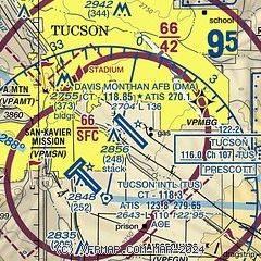
|
 Download PDF
of official airport diagram from the FAA
| Airport distance calculator |
|---|
|
|
| Sunrise and sunset |
|---|
|
Times for 06-May-2026
| | Local
(UTC-7) | | Zulu
(UTC) |
|---|
| Morning civil twilight | | 05:07 | | 12:07 |
| Sunrise | | 05:34 | | 12:34 |
| Sunset | | 19:07 | | 02:07 |
| Evening civil twilight | | 19:33 | | 02:33 |
|
| Current date and time |
|---|
| Zulu (UTC) | 06-May-2026 07:01:27 |
|---|
| Local (UTC-7) | 06-May-2026 00:01:27 |
|---|
|
| METAR |
|---|
| KDMA | 060655Z AUTO 00000KT 10SM CLR 17/07 A2998 RMK AO2 SLP122 T01670068 402490152 TSNO $
|
KTUS
4nm SW | 060653Z 25006KT 10SM FEW075 16/07 A2999 RMK AO2 SLP124 T01610067 402440150 $
|
KRYN
15nm W | 060245Z 25009KT 10SM CLR 220/05 A2989
|
|
| TAF |
|---|
| KDMA | 060245Z 0603/0709 25009KT 9999 SCT060 QNH2992INS BECMG 0607/0608 12009KT 9999 FEW060 QNH3000INS BECMG 0615/0616 VRB06KT 9999 SKC QNH3001INS BECMG 0620/0621 30012KT 9999 SKC QNH2995INS BECMG 0702/0703 VRB06KT 9999 SKC QNH2997INS TX24/0623Z TN11/0611Z
|
KTUS
4nm SW | 060520Z 0606/0706 26008KT P6SM SCT080 FM060900 17006KT P6SM FEW080 FM061900 33007KT P6SM FEW090 FM070400 24005KT P6SM SKC
|
|
| NOTAMs |
|---|
NOTAMs are issued by the DoD/FAA and will open in a separate window not controlled by AirNav.
|
|


