FAA INFORMATION EFFECTIVE 14 MAY 2026
Location
| FAA Identifier: | EDN |
| Lat/Long: | 31-17-59.0000N 085-53-59.4000W
31-17.983333N 085-53.990000W
31.2997222,-85.8998333
(estimated) |
| Elevation: | 360.9 ft. / 110.0 m (surveyed) |
| Variation: | 03W (2005) |
| From city: | 3 miles W of ENTERPRISE, AL |
| Time zone: | UTC -5 (UTC -6 during Standard Time) |
| Zip code: | 36330 |
Airport Operations
| Airport use: | Open to the public |
| Activation date: | 07/1955 |
| Control tower: | no |
| ARTCC: | JACKSONVILLE CENTER |
| FSS: | ANNISTON FLIGHT SERVICE STATION |
| NOTAMs facility: | ANB (NOTAM-D service available) |
| Attendance: | MONDAY - FRIDAY 0700 - 1700, ALL SATURDAY 0800 - 1700, ALL SUNDAY UNATNDD |
| Pattern altitude: | 1160.9 ft. MSL
800 FT AGL FOR CAT A AND B ACFT, 1500 FT AGL FOR CAT C ACFT. |
| Wind indicator: | lighted |
| Segmented circle: | yes |
| Lights: | REIL RWY 05 & 23; PAPI RWY 05 & 23; MIRL RWY 5/23 OPER DUSK-2330; AFTER 2330 ACTVT - CTAF. |
| Beacon: | white-green (lighted land airport)
Operates sunset to sunrise. |
Airport Communications
| CTAF/UNICOM: | 122.8 |
| WX AWOS-3PT: | 118.9 (334-347-3524) |
| CAIRNS APPROACH: | 133.45 |
| CAIRNS DEPARTURE: | 133.45 |
- APCH/DEP SVC PRVDD BY JACKSONVILLE ARTCC ON FREQS 134.3/322.55 (DOTHAN RCAG) WHEN CAIRNS APCH/DEP CLSD.
Nearby radio navigation aids
| VOR radial/distance | | VOR name | | Freq | | Var |
|---|
| EDN at field | | ENTERPRISE VOR | | 116.60 | | 03W |
| OZRr285/9.1 | | CAIRNS VOR/DME | | 111.20 | | 03W |
| HEYr254/(13.4) | | HANCHEY VOR | | 110.60 | | 03W |
| RRSr270/24.0 | | WIREGRASS VORTAC | | 111.60 | | 02E |
| NDB name | | Hdg/Dist | | Freq | | Var | | ID |
|---|
| BOLL WEEVIL | | 122/4.8 | | 352 | | 03W | | BVG | -... ...- --. |
| BLOOD | | 166/33.6 | | 365 | | 04W | | TOI | - --- .. |
Airport Services
| Fuel available: | 100LL JET-A+ |
| Parking: | tiedowns |
| Airframe service: | MINOR |
| Powerplant service: | MINOR |
| Bottled oxygen: | NONE |
| Bulk oxygen: | NONE |
Runway Information
Runway 5/23
| Dimensions: | 5080 x 100 ft. / 1548 x 30 m |
| Surface: | asphalt, in good condition |
| Runway edge lights: | medium intensity |
| RUNWAY 5 | | RUNWAY 23 |
| Latitude: | 31-17.724462N | | 31-18.241587N |
| Longitude: | 085-54.374587W | | 085-53.606833W |
| Elevation: | 342.4 ft. | | 353.2 ft. |
| Traffic pattern: | left | | left |
| Runway heading: | 055 magnetic, 052 true | | 235 magnetic, 232 true |
| Markings: | nonprecision, in good condition | | nonprecision, in fair condition |
| Visual slope indicator: | 2-light PAPI on left (3.00 degrees glide path) | | 2-light PAPI on left (3.50 degrees glide path) |
| Runway end identifier lights: | yes | | yes |
| Touchdown point: | yes, no lights | | yes, no lights |
| Obstructions: | 27 ft. tree, 726 ft. from runway, 130 ft. right of centerline, 19:1 slope to clear | | none |
Airport Ownership and Management from official FAA records
| Ownership: | Publicly-owned |
| Owner: | TOWN OF ENTERPRISE
P.O.BOX 311000
ENTERPRISE, AL 36330
Phone 334-348-2671 |
| Manager: | BARRY MOTT
863 AVIATION BLVD.
ENTERPRISE, AL 36330
Phone 334-348-2676
ADDL PHONE 334-348-2673; AFT HRS 334-406-7676. |
Additional Remarks
| - | FOR CD CTC CAIRNS APCH AT 334-255-8402, WHEN APCH CLSD CTC JACKSONVILLE ARTCC AT 904-845-1592. |
Instrument Procedures
NOTE: All procedures below are presented as PDF files. If you need a reader for these files, you should download the free Adobe Reader.NOT FOR NAVIGATION. Please procure official charts for flight.
FAA instrument procedures published for use from 14 May 2026 at 0901Z to 11 June 2026 at 0900Z.
IAPs - Instrument Approach Procedures |
|---|
| RNAV (GPS) RWY 05 | |
download (232KB) |
| VOR RWY 05 | |
download (193KB) |
| NOTE: Special Take-Off Minimums/Departure Procedures apply | |
download (189KB) |
Other nearby airports with instrument procedures:
KSXS - Shell Army Heliport (5 nm NE)
KLOR - Lowe Army Heliport (Fort Rucker) (8 nm NE)
KOZR - Cairns Army Airfield (Fort Rucker) (10 nm E)
KHEY - Hanchey Army Heliport (Fort Rucker) (13 nm E)
33J - Geneva Municipal Airport (15 nm S)
71J - Ozark/Blackwell Field Airport (16 nm NE)
|
|

Road maps at:
MapQuest
Bing
Google
| Aerial photo |
|---|
WARNING: Photo may not be current or correct
 Photo by Anita Blake
Taken early June 2017
from the south.
Photo by Anita Blake
Taken early June 2017
from the south.
Do you have a better or more recent aerial photo of Enterprise Municipal Airport that you would like to share? If so, please send us your photo.
|
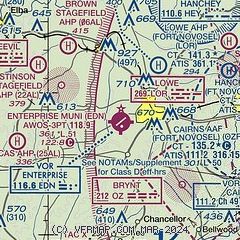
| Sectional chart |
|---|
|
| Airport distance calculator |
|---|
|
|
| Sunrise and sunset |
|---|
|
Times for 26-May-2026
| | Local
(UTC-5) | | Zulu
(UTC) |
|---|
| Morning civil twilight | | 05:16 | | 10:16 |
| Sunrise | | 05:43 | | 10:43 |
| Sunset | | 19:38 | | 00:38 |
| Evening civil twilight | | 20:06 | | 01:06 |
|
| Current date and time |
|---|
| Zulu (UTC) | 26-May-2026 07:28:10 |
|---|
| Local (UTC-5) | 26-May-2026 02:28:10 |
|---|
|
| METAR |
|---|
| KEDN | 260715Z AUTO 11011KT 10SM CLR 21/21 A2997 RMK AO1 T02070206
|
KSXS
5nm NE | 260655Z AUTO 15005KT 10SM BKN140 22/21 A2997 RMK AO2 SLP148 T02150210 $
|
KLOR
8nm E | 260717Z AUTO 08003KT 10SM -RA FEW140 22/21 A2997 RMK AO2 RAB17 SLP131 $
|
KOZR
9nm E | 260710Z AUTO 12003KT 10SM -DZ FEW090 BKN130 OVC160 22/21 A2997 RMK AO2 DZB10 SLP148 $
|
KHEY
13nm E | 260717Z AUTO 00000KT 9SM -RA BKN140 22/21 A2998 RMK AO2 RAB17 SLP152 $
|
|
| NOTAMs |
|---|
NOTAMs are issued by the DoD/FAA and will open in a separate window not controlled by AirNav.
|
|

