FAA INFORMATION EFFECTIVE 14 MAY 2026
Location
| FAA Identifier: | 71J |
| Lat/Long: | 31-25-54.5232N 085-37-13.9221W
31-25.908720N 085-37.232035W
31.4318120,-85.6205339
(estimated) |
| Elevation: | 357.9 ft. / 109.1 m (surveyed) |
| Variation: | 04W (2015) |
| From city: | 2 miles SE of OZARK, AL |
| Time zone: | UTC -5 (UTC -6 during Standard Time) |
| Zip code: | 36360 |
Airport Operations
| Airport use: | Open to the public |
| Activation date: | 06/1956 |
| Control tower: | no |
| ARTCC: | JACKSONVILLE CENTER |
| FSS: | ANNISTON FLIGHT SERVICE STATION |
| NOTAMs facility: | ANB (NOTAM-D service available) |
| Attendance: | MON-FRI 0800-1700
AFT HRS SVC CALL 334-432-0039. |
| Wind indicator: | lighted |
| Segmented circle: | yes |
| Lights: | ACTVT REIL RWY 13 & 31; PAPI RWY 13 & 31; MIRL RWY 13/31 - CTAF. |
| Beacon: | white-green (lighted land airport)
Operates sunset to sunrise. |
Airport Communications
| CTAF/UNICOM: | 122.7 |
| CAIRNS APPROACH: | 125.4 [0600-2300] |
| CAIRNS DEPARTURE: | 125.4 [0600-2300] |
| WX ASOS at DHN (11 nm SE): | PHONE 334-983-5999 |
| WX AWOS-3PT at HDL (16 nm E): | 119.575 (334-693-0508) |
| WX AWOS-3PT at EDN (16 nm SW): | 118.9 (334-347-3524) |
- APCH/DEP SVC PRVDD BY JACKSONVILLE ARTCC ON FREQS 134.3/322.55 (DOTHAN RCAG) WHEN CAIRNS APCH/DEP CLSD.
Nearby radio navigation aids
| VOR radial/distance | | VOR name | | Freq | | Var |
|---|
| HEYr029/(3.8) | | HANCHEY VOR | | 110.60 | | 03W |
| OZRr032/11.2 | | CAIRNS VOR/DME | | 111.20 | | 03W |
| RRSr310/13.1 | | WIREGRASS VORTAC | | 111.60 | | 02E |
| EDNr064/(16.6) | | ENTERPRISE VOR | | 116.60 | | 03W |
| EUFr217/39.9 | | EUFAULA VOR/DME | | 109.20 | | 02E |
| NDB name | | Hdg/Dist | | Freq | | Var | | ID |
|---|
| BOLL WEEVIL | | 076/19.3 | | 352 | | 03W | | BVG | -... ...- --. |
| BLOOD | | 138/34.5 | | 365 | | 04W | | TOI | - --- .. |
Airport Services
| Fuel available: | 100LL JET-A
100LL:AVGAS 24 HR CREDIT CARD SVC AVBL. |
| Parking: | tiedowns |
| Airframe service: | MAJOR |
| Powerplant service: | MAJOR |
| Bottled oxygen: | NONE |
| Bulk oxygen: | NONE |
Runway Information
Runway 13/31
| Dimensions: | 5152 x 80 ft. / 1570 x 24 m |
| Surface: | asphalt, in fair condition |
| Weight bearing capacity: | |
| Runway edge lights: | medium intensity |
| RUNWAY 13 | | RUNWAY 31 |
| Latitude: | 31-26.129053N | | 31-25.688437N |
| Longitude: | 085-37.655898W | | 085-36.808283W |
| Elevation: | 357.9 ft. | | 340.8 ft. |
| Traffic pattern: | left | | left |
| Runway heading: | 125 magnetic, 121 true | | 305 magnetic, 301 true |
| Markings: | nonprecision, in fair condition | | nonprecision, in fair condition |
| Visual slope indicator: | 4-light PAPI on right (3.60 degrees glide path) | | 4-light PAPI on left (3.00 degrees glide path) |
| Runway end identifier lights: | yes | | yes |
| Touchdown point: | yes, no lights | | yes, no lights |
| Obstructions: | 45 ft. tree, 615 ft. from runway, 615 ft. left of centerline, 9:1 slope to clear
CTLG OBSTN EXCEEDS A 45 DEG SLP. | | 19 ft. tree, 247 ft. from runway, 163 ft. right of centerline, 2:1 slope to clear |
Airport Ownership and Management from official FAA records
| Ownership: | Publicly-owned |
| Owner: | TOWN OF OZARK
P.O. BOX 1987
OZARK, AL 36361
Phone 334-774-5393 |
| Manager: | DENISE ELLIS
3269 HWY 231 S
OZARK, AL 36360
Phone 334-445-5045 |
Additional Remarks
| - | LOW FLYING HOP IN TFC PAT. |
| - | RWY & PARL TWYS CNTRLN SEPN IS 240 FT. |
| - | PILOTS DEPG BLACKWELL VFR TO THE EAST OR NORTH RMN AT 1500 FT MSL OR BLW TIL APRXLY 5 MI FM THE ARPT TO AVOID CONFLICT WITH TFC ON IFR APCH TO THE DOTHAN ARPT. |
| - | FOR CD CTC CAIRNS APCH AT 334-255-8402, WHEN APCH CLSD CTC JACKSONVILLE ARTCC AT 904-845-1592. |
| - | RWY 13/31 CLSD TO HEL RUNNING LDG BY SKID EQUIPPED HEL |
Instrument Procedures
NOTE: All procedures below are presented as PDF files. If you need a reader for these files, you should download the free Adobe Reader.NOT FOR NAVIGATION. Please procure official charts for flight.
FAA instrument procedures published for use from 14 May 2026 at 0901Z to 11 June 2026 at 0900Z.
IAPs - Instrument Approach Procedures |
|---|
| RNAV (GPS) RWY 13 | |
download (208KB) |
| RNAV (GPS) RWY 31 | |
download (201KB) |
| VOR RWY 31 | |
download (237KB) |
| NOTE: Special Take-Off Minimums/Departure Procedures apply | |
download (488KB) |
Other nearby airports with instrument procedures:
KHEY - Hanchey Army Heliport (Fort Rucker) (5 nm S)
KLOR - Lowe Army Heliport (Fort Rucker) (8 nm SW)
KOZR - Cairns Army Airfield (Fort Rucker) (11 nm SW)
KDHN - Dothan Regional Airport (11 nm SE)
KSXS - Shell Army Heliport (12 nm W)
KHDL - Headland Municipal Airport (16 nm E)
KEDN - Enterprise Municipal Airport (16 nm SW)
|
|

Road maps at:
MapQuest
Bing
Google
| Aerial photo |
|---|
WARNING: Photo may not be current or correct
 Photo by Bill Mansfield
Photo taken 20-Aug-2006
on final for runway 30
Photo by Bill Mansfield
Photo taken 20-Aug-2006
on final for runway 30
Do you have a better or more recent aerial photo of Ozark/Blackwell Field Airport that you would like to share? If so, please send us your photo.
|
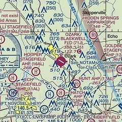
| Sectional chart |
|---|
|
| Airport distance calculator |
|---|
|
|
| Sunrise and sunset |
|---|
|
Times for 21-May-2026
| | Local
(UTC-5) | | Zulu
(UTC) |
|---|
| Morning civil twilight | | 05:17 | | 10:17 |
| Sunrise | | 05:44 | | 10:44 |
| Sunset | | 19:34 | | 00:34 |
| Evening civil twilight | | 20:01 | | 01:01 |
|
| Current date and time |
|---|
| Zulu (UTC) | 21-May-2026 09:00:49 |
|---|
| Local (UTC-5) | 21-May-2026 04:00:49 |
|---|
|
| METAR |
|---|
KHEY
5nm S | 210825Z AUTO 00000KT 5/8SM BR VV000 21/20 A3000 RMK AO2 VIS 5/8V1 1/2 SLP158 RVRNO
|
KLOR
8nm SW | 210845Z AUTO 00000KT 6SM BR FEW002 OVC200 20/20 A3000 RMK AO2 SLP140
|
KOZR
10nm SW | 210845Z AUTO 00000KT 3/8SM FG VV001 22/21 A2999 RMK AO2 SLP154 RVRNO
|
KDHN
11nm SE | 210853Z AUTO 35003KT 10SM OVC003 21/21 A3005 RMK AO1 SLP169 T02110206 55010 $
|
KSXS
12nm W | 210844Z AUTO 00000KT 10SM SCT002 OVC200 21/21 A3000 RMK AO2 SLP157
|
KEDN
16nm SW | 210835Z AUTO 00000KT 4SM BKN002 20/20 A3001 RMK AO1 T02030203
|
|
| TAF |
|---|
KOZR
10nm SW | 210200Z 2102/2208 VRB04KT 9999 FEW060 SCT120 QNH2998INS TEMPO 2109/2112 1600 BR BKN002 BECMG 2114/1215 19008KT 9999 SCT030 QNH2990INS TX32/2120Z TN20/2110Z LAST NO AMDS AFT 2106 NEXT 2110
|
KDHN
11nm SE | 210520Z 2106/2206 23004KT P6SM SCT070 FM210900 00000KT 6SM BR SCT080 TEMPO 2111/2114 3SM BR BKN002 FM211600 19006KT P6SM SCT230
|
|
| NOTAMs |
|---|
NOTAMs are issued by the DoD/FAA and will open in a separate window not controlled by AirNav.
|
|


