FAA INFORMATION EFFECTIVE 14 MAY 2026
Location
| FAA Identifier: | FTT |
| Lat/Long: | 38-50-17.2000N 092-00-09.3000W
38-50.286667N 092-00.155000W
38.8381111,-92.0025833
(estimated) |
| Elevation: | 886.6 ft. / 270.2 m (surveyed) |
| Variation: | 01E (2010) |
| From city: | 3 miles SW of FULTON, MO |
| Time zone: | UTC -5 (UTC -6 during Standard Time) |
| Zip code: | 65251 |
Airport Operations
| Airport use: | Open to the public |
| Activation date: | 03/1942 |
| Control tower: | no |
| ARTCC: | KANSAS CITY CENTER |
| FSS: | COLUMBIA FLIGHT SERVICE STATION |
| NOTAMs facility: | COU (NOTAM-D service available) |
| Attendance: | UNATTENDED |
| Wind indicator: | lighted |
| Segmented circle: | yes |
| Lights: | ACTVT REIL RWY 06, 24, 18 & 36; PAPI RWY 06, 24, 18 & 36; MIRL RWY 06, 24, 18 & 36 - CTAF. |
| Beacon: | white-green (lighted land airport)
Operates sunset to sunrise. |
Airport Communications
| CTAF/UNICOM: | 122.7 |
| MIZZU APPROACH: | 124.375 |
| MIZZU DEPARTURE: | 124.375 |
| WX ASOS at COU (10 nm W): | 128.45 (573-488-3025) |
| WX ASOS at JEF (16 nm SW): | 133.625 (573-635-9266) |
Nearby radio navigation aids
| VOR radial/distance | | VOR name | | Freq | | Var |
|---|
| COUr081/10.2 | | COLUMBIA VOR/DME | | 110.20 | | 00E |
| HLVr154/17.5 | | HALLSVILLE VORTAC | | 114.20 | | 06E |
Airport Services
| Fuel available: | 100LL |
| Parking: | hangars and tiedowns |
| Airframe service: | MAJOR |
| Powerplant service: | MAJOR |
Runway Information
Runway 18/36
| Dimensions: | 4001 x 75 ft. / 1220 x 23 m |
| Surface: | concrete, in good condition |
| Weight bearing capacity: | |
| Runway edge lights: | medium intensity |
| RUNWAY 18 | | RUNWAY 36 |
| Latitude: | 38-50.459662N | | 38-49.800965N |
| Longitude: | 091-59.992152W | | 092-00.020397W |
| Elevation: | 877.4 ft. | | 877.2 ft. |
| Traffic pattern: | left | | left |
| Runway heading: | 180 magnetic, 181 true | | 000 magnetic, 001 true |
| Markings: | nonprecision, in fair condition | | nonprecision, in fair condition |
| Visual slope indicator: | 4-light PAPI on left (3.00 degrees glide path) | | 4-light PAPI on left (3.00 degrees glide path) |
| Runway end identifier lights: | yes | | yes |
| Touchdown point: | yes, no lights | | yes, no lights |
| Obstructions: | none | | 50 ft. trees, 1215 ft. from runway, 270 ft. right of centerline, 20:1 slope to clear |
Runway 6/24
| Dimensions: | 3203 x 60 ft. / 976 x 18 m |
| Surface: | concrete, in excellent condition |
| Weight bearing capacity: | | PCN 5 /R/C/W/T | | Single wheel: | 30.0 |
|
| Runway edge lights: | medium intensity |
| RUNWAY 6 | | RUNWAY 24 |
| Latitude: | 38-50.259345N | | 38-50.545888N |
| Longitude: | 092-00.494518W | | 091-59.928070W |
| Elevation: | 879.3 ft. | | 881.3 ft. |
| Traffic pattern: | left | | left |
| Runway heading: | 056 magnetic, 057 true | | 236 magnetic, 237 true |
| Markings: | nonprecision, in good condition | | nonprecision, in good condition |
| Visual slope indicator: | 2-light PAPI on left (3.00 degrees glide path) | | 2-light PAPI on left (4.00 degrees glide path) |
| Runway end identifier lights: | yes | | yes |
| Touchdown point: | yes, no lights | | yes, no lights |
| Obstructions: | none | | 15 ft. road, 315 ft. from runway, 250 ft. right of centerline, 7:1 slope to clear |
Runway 12/30
| Dimensions: | 2488 x 100 ft. / 758 x 30 m |
| Surface: | turf, in fair condition |
| Runway edge markings: | 12/30 MARKED WTH LARGE YELLOW CONES. |
| RUNWAY 12 | | RUNWAY 30 |
| Latitude: | 38-50.504730N | | 38-50.277803N |
| Longitude: | 092-00.540865W | | 092-00.104440W |
| Elevation: | 885.4 ft. | | 875.9 ft. |
| Traffic pattern: | left | | left |
| Runway heading: | 123 magnetic, 124 true | | 303 magnetic, 304 true |
| Touchdown point: | yes, no lights | | yes, no lights |
Airport Ownership and Management from official FAA records
| Ownership: | Publicly-owned |
| Owner: | CITY OF FULTON
18 E. 4TH ST, BOX 130
FULTON, MO 65251
Phone 573-592-3111 |
| Manager: | MATT EASLEY
4420 COUNTY RD 304
FULTON, MO 65251
Phone 573-544-6906
AMGR CELL: 573-544-6906. AFTER HOURS CONTACT CITY OF FULTON POWER PLANT: 573-592-3180 |
Additional Remarks
| - | FOR CD CTC MIZZOU APCH AT 417-868-5620/5619. |
Instrument Procedures
NOTE: All procedures below are presented as PDF files. If you need a reader for these files, you should download the free Adobe Reader.NOT FOR NAVIGATION. Please procure official charts for flight.
FAA instrument procedures published for use from 14 May 2026 at 0901Z to 11 June 2026 at 0900Z.
IAPs - Instrument Approach Procedures |
|---|
| RNAV (GPS) RWY 06 **CHANGED** | |
download (245KB) |
| RNAV (GPS) RWY 18 **CHANGED** | |
download (230KB) |
| RNAV (GPS) RWY 24 **CHANGED** | |
download (256KB) |
| RNAV (GPS) RWY 36 **CHANGED** | |
download (229KB) |
| NOTE: Special Take-Off Minimums/Departure Procedures apply | |
download (435KB) |
Other nearby airports with instrument procedures:
KCOU - Columbia Regional Airport (10 nm W)
KJEF - Jefferson City Memorial Airport (16 nm SW)
KMYJ - Mexico Memorial Airport (21 nm NE)
KVER - Jesse Viertel Memorial Airport (32 nm W)
H79 - Eldon Model Airpark (39 nm SW)
|
|

Road maps at:
MapQuest
Bing
Google
| Aerial photo |
|---|
WARNING: Photo may not be current or correct
 Photo taken 26-Sep-2006
looking north.
Photo taken 26-Sep-2006
looking north.
Do you have a better or more recent aerial photo of Elton Hensley Memorial Airport that you would like to share? If so, please send us your photo.
|
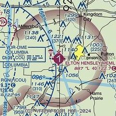
| Sectional chart |
|---|
|
| Airport distance calculator |
|---|
|
|
| Sunrise and sunset |
|---|
|
Times for 16-May-2026
| | Local
(UTC-5) | | Zulu
(UTC) |
|---|
| Morning civil twilight | | 05:26 | | 10:26 |
| Sunrise | | 05:56 | | 10:56 |
| Sunset | | 20:13 | | 01:13 |
| Evening civil twilight | | 20:43 | | 01:43 |
|
| Current date and time |
|---|
| Zulu (UTC) | 16-May-2026 07:11:45 |
|---|
| Local (UTC-5) | 16-May-2026 02:11:45 |
|---|
|
| METAR |
|---|
KCOU
10nm W | 160654Z AUTO 00000KT 10SM CLR 19/15 A2978 RMK AO2 SLP077 T01940150 $
|
KJEF
16nm SW | 160653Z AUTO 00000KT 10SM CLR 22/16 A2977 RMK AO2 SLP068 T02170156
|
|
| TAF |
|---|
KCOU
10nm W | 160520Z 1606/1706 18007KT P6SM SCT200 FM160900 19007KT 6SM -SHRA BKN100 TEMPO 1610/1613 4SM -TSRA OVC050CB FM161300 13007KT 6SM -SHRA OVC090 FM161500 17008KT P6SM BKN100 FM162300 13009KT P6SM SCT100
|
KJEF
16nm SW | 160520Z 1606/1706 VRB04KT P6SM SCT200 FM161000 VRB04KT 6SM -SHRA OVC090 TEMPO 1611/1614 4SM -TSRA OVC050CB FM161600 16006KT P6SM BKN100 FM162300 13007KT P6SM SCT100
|
|
| NOTAMs |
|---|
NOTAMs are issued by the DoD/FAA and will open in a separate window not controlled by AirNav.
|
|


